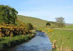
Bowmont Water
| Bowmont Water | |
 Bowmont Water near Mowhaugh | |
| Country | United Kingdom |
|---|---|
| County | Northumberland |
| Mouth | |
| - coordinates | 55°34′16″N 2°08′56″W / 55.571°N 2.149°WCoordinates: 55°34′16″N 2°08′56″W / 55.571°N 2.149°W |
 Location within Northumberland | |
Bowmont Water is a stream in the Scottish Borders and Northumberland, England.
It rises in the Cheviot Hills and flows by Mowhaugh, Town Yetholm, and Kirk Yetholm. It then crosses the Anglo-Scottish border and continues past Mindrum Mill, Mindrum Station, Thornington, and finally to Lanton Mill where it joins College Burn to form the River Glen.
See also
References
- Mercer and Tipping, R {J} and R (1988), 'Bowmont Valley, Roxburghshire', Univ Edinburgh Dept Archaeol Annu Rep, vol.34 Page 23, No.9.7
External links
- RCAHMS. "Bowmont Valley, Bowmont Water (59119)". Canmore.
- RCAHMS. "Bowmont Water, Rig and Furrow (280408)". Canmore.
- Scottish Borders Council: Local Cycling Trails - Kelso
- Geograph image: Bowmont Water and Westnewton Burn
- Geograph image: Bowmont Water near Pawston
This article is issued from
Wikipedia.
The text is licensed under Creative Commons - Attribution - Sharealike.
Additional terms may apply for the media files.