Borsod County
| Borsod County Comitatus Borsodiensis (Latin) Borsod vármegye (Hungarian) Komitat Borschod (German) | |||||
| County of the Kingdom of Hungary | |||||
| |||||
|
Coat of arms | |||||
 | |||||
| Capital | Miskolc 48°6′N 20°47′E / 48.100°N 20.783°ECoordinates: 48°6′N 20°47′E / 48.100°N 20.783°E | ||||
| History | |||||
| • | Established | 11th century | |||
| • | Disestablished | 1 January 1950 | |||
| Area | |||||
| • | 1910 | 3,629 km2 (1,401 sq mi) | |||
| Population | |||||
| • | 1910 | 289,900 | |||
| Density | 79.9 /km2 (206.9 /sq mi) | ||||
| Today part of | Hungary | ||||
Borsod was an administrative county (comitatus) of the Kingdom of Hungary in present-day northeastern Hungary. The capital of the county was Miskolc. After World War II, the county was merged with the Hungarian parts of Abaúj-Torna and Zemplén counties to form Borsod-Abaúj-Zemplén county.
Geography
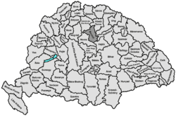
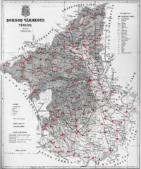
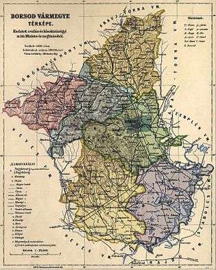
Before World War I, Borsod county shared borders with the counties Gömör-Kishont, Abaúj-Torna, Zemplén, Szabolcs, Hajdú and Heves. The river Tisza formed the southeastern border, and the river Sajó flowed through the county. Its area was 3629 km² around 1910.
History
Borsod is one of the oldest counties of the Kingdom of Hungary. In the early history of the Kingdom of Hungary each county (in Latin comitatus) formed around a castle (the majority of these castles were motte castles; most of the stone-built castles were constructed after the Mongol invasion of Hungary in the mid-13th century). The castle – which stood near modern-day Edelény – bore the name of its first steward, Bors, who lived during the reigns of either High Prince Géza or his son Stephen I. In old Hungarian language the -d suffix was a derivational suffix for place names, thus "Borsod" means "(a place) belonging to Bors". The name bors is of Turkish origin and means "pepper" both in old and modern Hungarian language (though in modern Hungarian it is not used as a personal name).
The county's borders became permanent in the early 14th century, when the neighbouring Torna County was formed, and they remained basically unchanged for the next six hundred years. Judging from the place names, originally the majority of the population were ethnic Hungarians, but later other groups immigrated to the area too: Pechenegs (in the late 10th/early 11th century) and úz groups (11th–12th century). This is also evident from place names like Szirmabesenyő (besenyő is the Hungarian word for Pecheneg) and Ózd (from "úz").
The parishes of the county belonged to the Diocese of Eger from the beginning. Several monasteries were founded in the region, in Százd (by the Aba clan, 11th century), Boldva (by the queen, 12th century), Kács (by the Örsúr clan), Tapolca (by the Miskolc clan), Bélháromkút (by the Bishop of Eger, after 1232).

The Battle of Mohi – marking the beginning of the Mongol invasion which had a disastrous effect on Hungary – took place in Borsod county, near the village of Muhi, on 11 April 1241. The Mongols defeated the army of King Béla IV. During the two-year invasion, 16 of the county's 69 villages were completely destroyed.
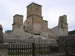
In 1248, when King Béla ordered stone castles to be built throughout the kingdom, several new castles were constructed in Borsod county too (Cserépvár, Csorbakő, Dédes, Diósgyőr, Éleskő), many in places of former, destroyed motte castles. The monastery of Boldva was destroyed during a second Mongol invasion in 1285.
In the papal tithe registers from 1332–1335, the county is mentioned as having 91 parishes. The county had about 240 villages at that time. Before the battle of Mohács (1526), which marks the beginning of the Ottoman occupation of Hungary (lasting for over 160 years) the county had 13 castles, 13 market towns (oppidum, including Miskolc and Mezőkövesd) and 250 villages, owned by 235 different feudal lords including dioceses and monasteries. The steward of the county was the captain of the Castle of Diósgyőr.
In 1566, the Ottomans occupied the castles of Dédes and Diósgyőr, and after the Battle of Mezőkeresztes ( 26–28 October 1596) they occupied Miskolc too. The area was under Ottoman control until 1687.
In the next century, an important historical event of Prince Rákóczi's freedom fight took place in the county: the Diet of Ónod, where Hungary was declared independent of Habsburg rule, was held here, next to the village of Ónod, on 18 June 1707.
In 1724, it was decided that the county hall of Borsod would be built in Miskolc, thus the town officially became the seat of the county. The building was constructed between 1825–1827.

There were some minor changes in the area of the county during the 19th century: between 1807 and 1812 the villages Szőlőske, Cegléd, Tihamér, Almagyar, Felnémet and Bekölce (many of these are today city parts of Eger) were annexed to the neighbouring Heves county, while Egerfarmos, Ivánka, Szőkepuszta and the mill of Kistálya were annexed from Heves to Borsod. In 1850 several other towns and villages of Borsod were annexed to neighbouring counties: Andornak, Kistálya and Felsőtárkány to Heves, Domaháza and Sikátor to Gömör and Kishont. Onga, formerly belonging to Abaúj county, and Külsőböcs, formerly of Zemplén county, became parts of Borsod. In 1907 Miskolc was granted the rank of city with municipal rights, becoming de jure independent from Borsod county.
In 1910, the county had 289,492 inhabitants (281,871 Hungarians, 2,379 Germans, 4,115 Slovaks; 160,699 Roman Catholics, 14,086 Greek Catholics, 7,299 Evangelicals, 88,856 Calvinists, 18,346 Jews). Of the 63 counties of Hungary it was the 39th largest by area, 23rd largest by population and 11th largest by population density (80 persons/km² in 1910). Between 1899 and 1913 many people left Hungary and emigrated to other countries; from Borsod 23,797 people emigrated, which, not counting the 7,313 who eventually came back, makes the county 18th in the list of Hungarian counties with the most emigrees.
After World War I and the Treaty of Trianon, Hungary lost many of its territories to neighbouring countries. The loss did not affect Borsod county, its borders remained unchanged, but of the surrounding counties Abaúj-Torna (Abaúj had been merged with Torna in 1882) lost 48% of its area to the newly formed state of Czechoslovakia, Zemplén lost 72% and Gömör-Kishont lost 92.5%. In 1924, Borsod county was merged with the remaining parts of former Gömör-Kishont county to form "Borsod-Gömör-Kishont temporarily united county" with its capital at Miskolc.
In 1919, Borsod county had 177 villages (13 of them had a population larger than 2000).
On 2 November 1938, the First Vienna Award returned to Hungary some parts of Gömör and Kishont lost in 1918; Borsod and Gömör-Kishont became independent from each other again but the border between them slightly changed.
In 1941, the county had 382,324 inhabitants (378,303 Hungarians, 272 Germans, 240 Slovaks, 165 Romanians, 210 Ruthenians, 2103 Gypsies and 2324 other; 225,476 Roman Catholics, 19,625 Greek Catholics, 226 Greek Orthodox, 8657 Evangelicals, 109,809 Protestants, 105 Unitarians, 970 Baptists, 16,997 Jews, 164 of other religions.
After World War II, the Vienna Award was declared void, Hungary lost the northern territories to Czechoslovakia again, and in 1945 the 1938 law was repealed and the remaining part of Gömör-Kishont was merged with Borsod county again, forming Borsod-Gömör county. On 16 March 1950, during an extensive administrative reform, the remaining parts of Abaúj-Torna and Zemplén counties were annexed to Borsod-Gömör, creating the modern-day county of Borsod-Abaúj-Zemplén, with only Borsod's county seat Miskolc keeping its county seat status – Sátoraljaújhely, of Zemplén, and Szikszó, of Abaúj county, lost it.
Today the area that was once Borsod county is the most urbanized and industrialized area of Borsod-Abaúj-Zemplén, with 3/4 of the county's population living here. The county's three largest cities – Miskolc, Ózd and Kazincbarcika – can be found here. In colloquial speech Borsod county is often used to mean Borsod-Abaúj-Zemplén as a whole.
Historical population
| 1782 | 1869 | 1880 | 1890 | 1900 | 1910 | 1941 | 1949 | 2001 |
| 134.223 | 193.707 | 193.839 | 216.794 | 255.194 | 289.492 | 382.324 | 387.167* | 739.143** |

In 1900, the county had a population of 257,586 people and was composed of the following linguistic communities:[1]
Total:
- Hungarian: 243,117 (94.4%)
- Slovak: 9,338 (3.6%)
- German: 3,155 (1.2%)
- Romanian: 349 (0.1%)
- Serbian: 32 (0.0%)
- Croatian: 28 (0.0%)
- Ruthenian: 72 (0.0%)
- Other or unknown: 1,495 (0.6%)
According to the census of 1900, the county was composed of the following religious communities:[2]
Total:
- Roman Catholic: 137,980 (53.6%)
- Calvinist: 83,310 (32.3%)
- Jewish: 16,477 (6.4%)
- Greek Catholic: 12,850 (5.0%)
- Lutheran: 6,700 (2.6%)
- Greek Orthodox: 210 (0.0%)
- Unitarian: 30 (0.0%)
- Other or unknown: 29 (0.0%)
* as Borsod-Gömör
** Borsod-Abaúj-Zemplén
Subdivisions

In the early 20th century, the subdivisions of Borsod county were:
| Districts (járás) | |
|---|---|
| District | Capital |
| Edelény District | Edelény |
| Mezőcsát District | Mezőcsát |
| Mezőkövesd District | Mezőkövesd |
| Miskolc District | Miskolc |
| Ózd District | Ózd |
| Sajószentpéter District | Sajószentpéter |
| Urban counties (törvényhatósági jogú város) | |
| Miskolc | |
Sources
- Hungarian Catholic Lexicon (Hungarian only) (articles: Borsod, Gömör és Kishont közigazgatásilag egyelőre egyesített vármegye, Borsod vármegye, Borsod-Abaúj-Zemplén megye and Borsod-Gömör vármegye.)
- ↑ "KlimoTheca :: Könyvtár". Kt.lib.pte.hu. Retrieved 2012-12-06.
- ↑ "KlimoTheca :: Könyvtár". Kt.lib.pte.hu. Retrieved 2012-12-06.
.svg.png)
