Borje pri Mlinšah
| Borje pri Mlinšah | |
|---|---|
 | |
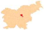
 Borje pri Mlinšah Location in Slovenia | |
| Coordinates: 46°10′3.34″N 14°50′0.94″E / 46.1675944°N 14.8335944°ECoordinates: 46°10′3.34″N 14°50′0.94″E / 46.1675944°N 14.8335944°E | |
| Country |
|
| Traditional region | Upper Carniola |
| Statistical region | Central Sava |
| Municipality | Zagorje ob Savi |
| Area | |
| • Total | 2.68 km2 (1.03 sq mi) |
| Elevation | 557.6 m (1,829.4 ft) |
| Population (2002) | |
| • Total | 35 |
| [1] | |
Borje pri Mlinšah (pronounced [ˈbɔːɾjɛ pɾi ˈmliːnʃax]) is a settlement west of Izlake in the Municipality of Zagorje ob Savi in central Slovenia. Traditionally the area was part of Upper Carniola. It is now included with the rest of the municipality in the Central Sava Statistical Region.[2] The settlement includes the hamlet of Zgornje Vrtače (in older sources also Gorenje Vrtače,[3] German: Oberwertatsche[3]).
Name
The name of the settlement was changed from Borje to Borje pri Mlinšah in 1955.[4]
Church
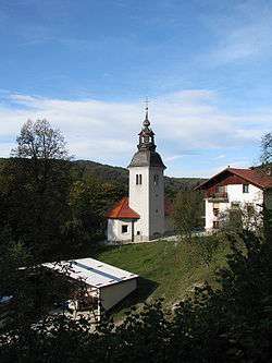
The local church is dedicated to Saint James (Slovene: sveti Jakob) and belongs to the Parish of Kolovrat. It dates to the 16th century and was first mentioned in written documents dating to 1523.[5]
References
- ↑ Statistical Office of the Republic of Slovenia
- ↑ Zagorje ob Savi municipal site Archived 2012-03-06 at the Wayback Machine.
- 1 2 Leksikon občin kraljestev in dežel zastopanih v državnem zboru, vol. 6: Kranjsko. 1906. Vienna: C. Kr. Dvorna in Državna Tiskarna, p. 93.
- ↑ Spremembe naselij 1948–95. 1996. Database. Ljubljana: Geografski inštitut ZRC SAZU, DZS.
- ↑ Slovenian Ministry of Culture register of national heritage reference number ešd 1898
External links
This article is issued from
Wikipedia.
The text is licensed under Creative Commons - Attribution - Sharealike.
Additional terms may apply for the media files.
