Black Hill, Victoria
| Black Hill Ballarat, Victoria | |||||||||||||||
|---|---|---|---|---|---|---|---|---|---|---|---|---|---|---|---|
 Corner of Napier and Peel Street. The Post Office is on the left and the Black Hill Hotel on the right. | |||||||||||||||
 Black Hill | |||||||||||||||
| Coordinates | 37°33′36″S 143°52′21″E / 37.5600°S 143.8726°ECoordinates: 37°33′36″S 143°52′21″E / 37.5600°S 143.8726°E | ||||||||||||||
| Population | 2,126 (2016 census)[1] | ||||||||||||||
| • Density | 1,222/km2 (3,165/sq mi) | ||||||||||||||
| Postcode(s) | 3350 | ||||||||||||||
| Area | 1.74 km2 (0.7 sq mi) | ||||||||||||||
| Location | 2 km (1 mi) from Ballarat Central | ||||||||||||||
| LGA(s) | City of Ballarat | ||||||||||||||
| State electorate(s) | Wendouree | ||||||||||||||
| Federal Division(s) | Ballarat | ||||||||||||||
| |||||||||||||||
Black Hill is a suburb of Ballarat, Victoria, Australia in the northeast of the city. The population at the 2016 census was 2,126.[1]
It is bordered to the south and east by the Yarrowee River and to the north by Howitt Street, Walker Street and Boronia/Haimes Road and Reid Street to the west by Havelock and Rowe Streets.
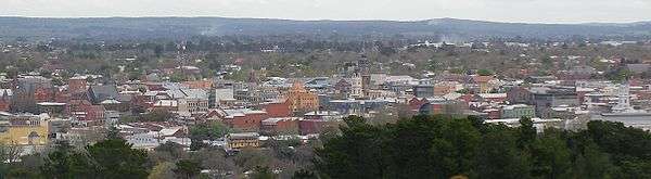
The hill after which it is named, originally named Bowdun by surveyor William Urquhart, is notable for its famous lookout from where most of Ballarat can be seen which is included on the Ballarat Treasures Register.
It is a former mining area and the hill was mined extensively during the Victorian gold rush.
History
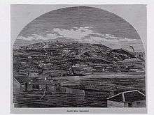
Black Hill was a gold mining and brick making area.
Black Hill Post Office opened on 7 June 1864.[2]
Education
The local primary school is Black Hill Primary School, located on Chisholm Street. It is government owned and has a kindergarten. The school has students from prep to year 6. It has 532 students enrolled.
Parks and reserves
One reserve in the area is the Black Hill Reserve and is approximately 21 hectares and is located just over 1 kilometre north‐east of the Ballarat CBD. The Yarrowee River, Ballarat’s major linear corridor, adjoins the Reserve to the south. Urban areas of residential development adjoin the Reserve to the north, east and west.
The hill is 495 metres above sea level making it the highest land in central Ballarat. It is a dominant landmark within the urban landscape of Ballarat and the lookout area at the top of the hill arguably provides the best panoramic views of the City.
Black Hill Reserve is historically significant as it was subject to extensive mining activity in the 1800’s and early 1900’s. The resulting terrain is steep and undulating with significant areas of exposed soils. The landscape has since been heavily forested with mature pine trees in plantations and more recent plantings of native trees.
The reserve has traditionally been used for viewing the City and for passive recreation, but in recent times has become a focal point for downhill mountain bike riding.
The reserve is going through an upgrade which will make the space much better.
Black Hill also has a public swimming pool, with a solar heated 25m outdoor pool, toddlers pool, BBQ and picnic facilities and a diving board. Black Hill Aquatic Centre operates with a weather policy: if the maximum temperature is below 23°c, the centre may close. In hot weather, the centre may open longer hours.
The Chisholm Street Reserve is a large grassland.
Transport
Black Hill has 2 bus routes, operated by CDC Ballarat. Route 13 goes from the Ballarat CBD to Invermay Park via Peel Street, Macarthur St and Lydiard St. Route 14 goes from the Ballarat CBD to part of Brown Hill and Chisholm Street, up Peel St and Havelock St and loops around Walker and Norman Sts. Black Hill's main North-South road is Peel Street.
References
- 1 2 Australian Bureau of Statistics (27 June 2017). "Black Hill (Vic) (State Suburb)". 2016 Census QuickStats. Retrieved 7 July 2017.

- ↑ Premier Postal History, Post Office List, retrieved 2008-04-11
External links
|