Bhattarai Danda
| Bhattarai Danda | |
|---|---|
| City | |
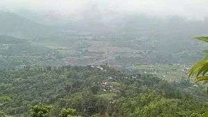 Bhattarai Danda seen from Mohami | |
 Bhattarai Danda Location in Nepal | |
| Coordinates: 27°52′59″N 83°55′52″E / 27.883°N 83.931°ECoordinates: 27°52′59″N 83°55′52″E / 27.883°N 83.931°E | |
| Country |
|
| Province | Gorkha |
| District | Syangja District |
| Municipality | Chapakot |
| City | Sankhar |
| Area | |
| • Total | 2.15 km2 (0.83 sq mi) |
| Population (2011 Nepal census) | |
| • Total | 5,510 |
| • Density | 2,600/km2 (6,600/sq mi) |
| • Ethnicities | Brahmin, Chhetri, Gurung |
| Time zone | Nepal Time (UTC+5:45) |
| • Summer (DST) | Pokhara (UTC) |
Bhattarai Danda Nepali: भट्टराई डाँडा is a City of Sankhar in Chapakot of Syangja District of Gorkha province in Nepal. Majority of its people are Brahmins and they are Bhattarai families, so the entire village is named accordingly. According to the 2011 Nepal census, held by Central Bureau of Statistics, it had a total population of 5510. There are 2,610 males and 2,800 females living in 846 households.[1]
Climate
| Bhattarai Danda | ||||||||||||||||||||||||||||||||||||||||||||||||||||||||||||
|---|---|---|---|---|---|---|---|---|---|---|---|---|---|---|---|---|---|---|---|---|---|---|---|---|---|---|---|---|---|---|---|---|---|---|---|---|---|---|---|---|---|---|---|---|---|---|---|---|---|---|---|---|---|---|---|---|---|---|---|---|
| Climate chart (explanation) | ||||||||||||||||||||||||||||||||||||||||||||||||||||||||||||
| ||||||||||||||||||||||||||||||||||||||||||||||||||||||||||||
| ||||||||||||||||||||||||||||||||||||||||||||||||||||||||||||
Education
Primary education is provided by Shree Gandaki Primary School. Secondary education is provided by Rivervalley Mathematics Anon Solution - RMAS
References
- ↑ "Syangja VDC Level Report" (PDF). Central Bureau of Statistics. Archived from the original (PDF) on 2014-10-26.
- ↑ "NASA Earth Observations Data Set Index". NASA. Retrieved 30 January 2016.
External links
See also
This article is issued from
Wikipedia.
The text is licensed under Creative Commons - Attribution - Sharealike.
Additional terms may apply for the media files.