Beskids
| Beskids | |
|---|---|
|
Beskidy (pl) Beskydy (cs/sk) | |
|
Eastern Beskids in Zakarpattia Oblast, Ukraine | |
| Highest point | |
| Peak | Hoverla |
| Elevation | 2,060 m (6,760 ft) |
| Coordinates | 48°09′36″N 24°30′01″E / 48.16000°N 24.50028°E |
| Dimensions | |
| Length | 600 km (370 mi) |
| Width | 70 km (43 mi) |
| Geography | |
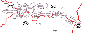
 Map of the Beskid ranges
| |
| Countries | Poland, Slovakia, Czech Republic and Ukraine |
| Regions | Silesia, Lesser Poland, Moravia and Carpathian Ruthenia |
| Range coordinates | 49°25′00″N 20°15′00″E / 49.416667°N 20.25°ECoordinates: 49°25′00″N 20°15′00″E / 49.416667°N 20.25°E |
| Parent range | Western and Eastern Carpathians |
| Borders on | Sudetes and Tatra Mountains |
The Beskids or Beskid Mountains (Polish: Beskidy, Czech and Slovak: Beskydy, Rusyn: Бескиды (Beskidy), Ukrainian: Бескиди (Beskydy)) is a traditional name for a series of mountain ranges in the Carpathians, stretching from the Czech Republic in the west along the border of Poland with Slovakia up to Ukraine in the east.
The highest mountain in the Beskids is Hoverla, at 2,061 m metres (6,762 ft), located in the Ukrainian Chornohora range.
Etymology
The origin of the name beskydy has not been conclusively established. A Thracian or Illyrian origin has been suggested, however, as yet, no theory has majority support among linguists. The word appears in numerous mountain names throughout the Carpathians and the adjacent Balkan regions, like in Albanian bjeshkë. The Slovak name Beskydy refers to the Polish Bieszczady Mountains, which is not a synonym for the entire Beskids but one single range, belonging to the Eastern Beskids. According to another linguistic theory, it may be related to Middle Low German beshêt, beskēt, meaning watershed.[1]
Historically the Beschad Alpes Poloniae, first mentioned in a 1269 deed and called Poloniae Alpe Biesczade in the 17th century, denoted the mountain ranges which separated the Kingdom of Poland from Ruthenia and the Kingdom of Hungary.
Definition
The Beskids are approximately 600 km in length and 50–70 km in width. They stand mainly along the southern border of Lesser Poland with northern Slovakia, stretching to the Moravia and Czech Silesia regions of the eastern Czech Republic and to Carpathian Ruthenia in western Ukraine. Parts form the European Watershed, separating the Oder and Vistula basins in the north from the Eastern Slovak Lowland, part of the Great Hungarian Plain drained by the Danube River.
Geologically all of the Beskids stand within the Outer Western Carpathians and the Outer Eastern Carpathians. In the west they begin at the natural pass of the Moravian Gate, which separates them from the Eastern Sudetes, continue east in a band to the north of the Tatra Mountains, and end in Ukraine. The eastern termination of the Beskids is disputed. According to older sources, the Beskids end at the source of the Tisza River, while newer sources state that the Beskids end at the Uzhok Pass at the Polish-Ukrainian border.
Subdivisions
Multiple traditions, languages and nationalities have developed overlapping variants for the divisions and names of the Beskid ranges. According to the divisions of the Carpathians, they are categorized within:
- Outer Western Carpathians
- West-Beskidian Piedmont, in the Czech Republic and Poland
- Western Beskids
- Hostýnsko-vsetínská hornatina, in the Czech Republic
- Moravian-Silesian Beskids, spanning the Czech Republic (Moravia and Czech Silesia) and Slovakia
- Silesian Beskids, southwest of Bielsko-Biała in Poland and the Czech Republic
- Żywiec Beskids, in Poland
- Polish Western Beskids (Beskidy Zachodnie)
- Central Beskids (Slovak: Stredné Beskydy)
- Orava Beskids, in Poland and Slovakia
- Orava Magura, in Slovakia
- Orava Highlands, in Slovakia
- Kysucké Beskydy, in Slovakia
- Slovak Eastern Beskids (Východné Beskydy)
- Outer Eastern Carpathians
- Central Beskidian Piedmont, in Poland
- Low Beskids (Slovak: Nízke Beskydy)
- Ondavská Highlands, in Slovakia
- Polish Low Beskids (Beskid Niski) and Slovak Laborec Highlands
- Eastern Beskids and the Ukrainian Carpathians
- Bieszczady Mountains in Poland and Bukovec Mountains in Slovakia
- Skole Beskids, in Ukraine
- Gorgany, in Ukraine
- Svydovets, in Ukraine
- Chornohora, in Ukraine
Infrastructure
The Beskids are currently rich in forest and coal. In the past they were rich in iron ore, with important plants in Ostrava and Třinec – Třinec Iron and Steel Works.
There are many tourist attractions, including historic wooden churches (see Wooden Churches of Southern Little Poland, Carpathian Wooden Churches of Slovakia, and Wooden Churches of Ukraine) and the increasingly popular skiing resorts.
A number of environmental groups support a small but growing population of bears, wolves and lynx in the ecosystem of the Beskidy mountains. The Central Beskids include the Polish Babia Góra National Park and the adjacent Slovak Horná Orava Protected Landscape Area.
Gallery
- Czantoria, Silesian Beskids
 Western Bieszczady
 Western Bieszczady

- Hoverla, Ukraine
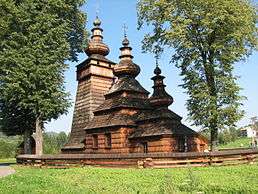
 Wooden church in Kwiatoń
- Wooden church in Hrabova, Moravia (14th - 1564)
References
- ↑ Zbigniew Gołąb. The Origins of the Slavs: A Linguist's View. Slavica Publishers, Inc., 1992 p. 342. "The Germanic etymology of Bieszczad // Beskid was proposed by prof. Jan Michał Rozwadowski (1914:162, etc). He derives the variant beščad from Germc. biskaid, wchich is represented by MLG besche (beskêt) Trennung and by Scandinavian bêsked, borrowed from [...]"
External links
| Wikivoyage has a travel guide for Beskids. |
| Wikimedia Commons has media related to The Beskids. |
- Beskidzki Serwis Internetowy (in Polish)
- Beskydy (in Czech)
