Bescar Lane railway station
| Bescar Lane | |
|---|---|
 | |
| Location | |
| Place | Scarisbrick |
| Local authority | West Lancashire |
| Grid reference | SD396145 |
| Operations | |
| Station code | BES |
| Managed by | Northern |
| Number of platforms | 2 |
| DfT category | F2 |
|
Live arrivals/departures, station information and onward connections from National Rail Enquiries | |
| Annual rail passenger usage* | |
| 2011/12 |
|
| 2012/13 |
|
| 2013/14 |
|
| 2014/15 |
|
| 2015/16 |
|
| History | |
| Key dates | Opened 9 April 1855 |
| Original company | Manchester and Southport Railway |
| Pre-grouping | Lancashire and Yorkshire Railway |
| National Rail – UK railway stations | |
| * Annual estimated passenger usage based on sales of tickets in stated financial year(s) which end or originate at Bescar Lane from Office of Rail and Road statistics. Methodology may vary year on year. | |
|
| |
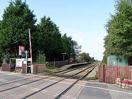
Bescar Lane railway station is on the Manchester to Southport Line, 4.5 miles (7.2 km) east of Southport in the village of Scarisbrick. Bescar Lane is an old cottage-style station, operated by the Northern franchise. Its remote location, some distance from the centre of Scarisbrick Parish, is considered "problematical".[1]
History
Bescar Lane station was built by the Manchester and Southport Railway and opened on 9 April 1855, and from January 1885 was part of the Lancashire and Yorkshire Railway (L&YR). The station had the distinction of being the lowest station on that network, situated 12.5 feet (3.8 m) above sea-level. The L&YR amalgamated with the London and North Western Railway on 1 January 1922 and in turn was grouped into the London, Midland and Scottish Railway (LMS) in 1923. Nationalisation followed in 1948. Part of the line running from Bescar Lane en route to Southport through Blowick and St Luke's closed in 1965 (as part of the Beeching Axe), forcing trains to divert through Meols Cop on a section of the old Liverpool, Southport and Preston Junction Railway.[2] When Sectorisation was introduced in the 1980s, the station was served by Regional Railways until the privatisation of British Rail.
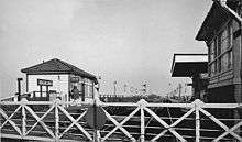
The station's level crossing was controlled by a signal box until the early 1990s,[3] but this was closed and demolished after automatic barriers were installed and the fixed signals removed. The platform layout has also been altered, with the westbound platform moved to the opposite side of the crossing - previously both platforms were sited on the eastern side (the redundant one can still be seen).[4]

Facilities
The station is unmanned and has no ticket machine, so all tickets must be purchased in advance or on the train. There are shelters on each platform, but no other permanent buildings. Train running information can be obtained from timetable posters or by telephone. Step-free access is available to both platforms.[5]
Services
Monday to Saturdays there is generally a two-hourly service to Southport westbound and Manchester Victoria via Wigan Wallgate and Atherton eastbound; a number of morning and evening peak Southport - Manchester Airport via Manchester Piccadilly services also call.[6]
The last service to Southport is at 21:29 and the last service towards Wigan Wallgate and Manchester stations is at 22:28. There is no Sunday service, though a normal service operates on most Bank Holidays.
References
- ↑ Village History, Scarisbrick.org.uk. Retrieved on 29 May 2008.
- ↑ Gell, Rob (1986). An Illustrated Survey of Railway Stations Between Southport & Liverpool 1848-1986. Heyday Publishing Company, ISBN 0-947562-04-4.
- ↑ Bescar Lane level crossing and signal box in June 1991 Railwaymedia.co.uk; Retrieved 19 December 2016
- ↑ Bescar Lane station in 2012 Thompson, Nigel Geograph.org; Retrieved 19 December 2016
- ↑ Bescar Lane station facilities National Rail Enquiries; Retrieved 19 December 2016
- ↑ Great Britain eNRT December 2016 Edition, Table 82
External links
 Media related to Bescar Lane railway station at Wikimedia Commons
- Bescar Lane Station Information at Northern Rail
| Preceding station | |
Following station | ||
|---|---|---|---|---|
| Meols Cop | Northern Manchester-Southport Line |
New Lane | ||
Coordinates: 53°37′26″N 2°54′54″W / 53.624°N 2.915°W