North Berwick Law
| North Berwick Law | |
|---|---|
 North Berwick Law seen from the seafront of North Berwick | |
| Highest point | |
| Elevation | 187 m (614 ft) |
| Prominence | c. 167 m |
| Listing | Marilyn |
| Coordinates | 56°02′55″N 2°42′57″W / 56.04859°N 2.71597°WCoordinates: 56°02′55″N 2°42′57″W / 56.04859°N 2.71597°W |
| Geography | |
 North Berwick Law | |
| OS grid | NT555842 |
| Topo map | OS Landranger 66 |
North Berwick Law is a conical hill which rises conspicuously from the surrounding landscape (this is the definition of the Lowland Scots word "law").[1] It overlooks the East Lothian town of North Berwick and stands at 613 ft (187 m) above sea level.
Geologically, the law is a volcanic plug of hard phonolitic trachyte rock of Carboniferous (Dinantian) age.[2] It has survived the scraping glaciers of the ice age. It is a crag and tail with a prominent tail extending eastwards.
The summit bears remnants of an Iron Age hill fort, and the ruins of later military buildings that were once used by lookouts in both the Napoleonic Wars, and in World War II.
The famous whale's jawbone collapsed in June 2005 after rotting away, and was removed by helicopter, much to the surprise of North Berwick residents. A jawbone has stood there since 1709, the last one having been there since 1933.
On 26 June 2008, a fibreglass replica whale bone, the same size as the one that was removed in 2005, was airlifted into place to give North Berwick Law back its famous landmark.[3] The funding for the replica was donated by an anonymous friend of North Berwick.
See also
Gallery
 North Berwick Law, North Berwick, East Lothian
 Berwick Law, seen from the town
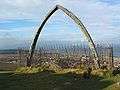 The whale's jawbone as it sat on top of North Berwick Law
 The replica of the original jawbone
 An anonymous friend of the town donated the replica jawbone
 Viewpoint indicator on North Berwick Law, with the Bass Rock in the background
References
- ↑ "Law". Dictionary of the Scots Language. Retrieved 2015-05-28.
- ↑ Read, W. A. et al. (2002) Carboniferous, page 294 in Trewin, N. H. (2002) The Geology of Scotland, 4th edition, London, The Geological Society.
- ↑ Scotsman.com
External links
- Computer-generated virtual panoramas North Berwick Law
- Stuart McHardy, The Goddess in the Landscape of Scotland