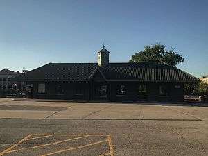
Bensenville station
 | |||||||||||
| Location |
110 West Main Street Bensenville, Illinois | ||||||||||
| Coordinates | 41°57′25″N 87°56′30″W / 41.9569°N 87.9418°WCoordinates: 41°57′25″N 87°56′30″W / 41.9569°N 87.9418°W | ||||||||||
| Line(s) | |||||||||||
| Platforms | 2 side platforms | ||||||||||
| Tracks | 2 | ||||||||||
| Connections |
| ||||||||||
| Construction | |||||||||||
| Disabled access | Yes | ||||||||||
| Other information | |||||||||||
| Fare zone | D | ||||||||||
| History | |||||||||||
| Opened | 1989 | ||||||||||
| Services | |||||||||||
| |||||||||||
Bensenville is a station on Metra's Milwaukee District/West in Bensenville, Illinois. The station is 17.2 miles (27.7 km) away from Union Station, the eastern terminus of the line.[1] In Metra's zone-based fare system, Bensenville is in zone D.
Bensenville Station is actually located on the south side of Main Street across from the railroad tracks. A wide at-grade pedestrian crosswalk provides access between West Main Street and the station. Parking is available along the south side of West Main Street west of Addison Street, but also behind the station house at the intersection of Center & Railroad Streets.
Bensenville will also serve Amtrak trains as a stop on the new Black Hawk service between Chicago and Rockford. It is currently unclear of when service will start.
Bus connections
- "Route 319 – Grand Avenue". PaceBus.com. Chicago: Pace Suburban Bus Service.
- "Route 332 – River Road/York Road". PaceBus.com. Chicago: Pace Suburban Bus Service.
Gallery
 Train approaching the station in the evening.
 An east to west view of the station during the early evening.
 An outbound train towards Elgin stopped at the Bensenville METRA station.
 An outbound train towards Elgin stopped at the Bensenville METRA station.
References
External links
- Chicago Railfan.net:
- Station from York Road from Google Maps Street View