Bear Valley, Colusa County, California
| Bear Valley | |
| Valley | |
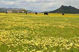 Bear valley during Spring 2017 with Bear Valley Buttes in background | |
| Country | United States |
|---|---|
| State | California |
| Region | Colusa County |
| Elevation | 1,310 ft (399 m) |
| Length | 12.5 mi (20 km) |

Bear Valley
Location in California
Coordinates: 39°08′17″N 122°25′59″W / 39.13805°N 122.43301°W

Field of California poppies in Bear Valley

Bear Valley during the parched summer months with Bear Creek in center
Bear Valley in Colusa County, California is formed by Bear Creek which is a tributary of Cache Creek.
Upstream in the Bear Creek watershed the creek flows for 10 miles through a broad flat valley that has spectacular displays of wildflowers in the spring.[1]
The Bear Valley Ranch and Payne Ranch in Bear Valley have been permanently protected through a conservation easement that precludes development on the property, while permitting traditional cattle ranching to continue.[2] [3] [4] [5]
Hiking through the valley is not permitted, but many people visit Bear Valley and neighboring valleys each spring for roadside viewing of this wildflower hotspot.[6] [7] [8]
References
- ↑ "Wildflower Viewing - Colusa County Resource Conservation District". Retrieved 16 March 2013.
- ↑ "Bear Valley Ranch - American Land Conservancy". Archived from the original on 13 June 2013. Retrieved 16 March 2013.
- ↑ "Payne Ranch | American Land Conservancy". Retrieved 16 March 2013.
- ↑ "A Cache of Treasures - American Land Conservancy - pdf" (PDF). Archived from the original (PDF) on 20 May 2011. Retrieved 16 March 2013.
- ↑ "Bear Valley - California Rangeland Trust". Retrieved 16 March 2013.
- ↑ "Bear Valley wildflowers - Sierra Club Trails". Retrieved 16 March 2013.
- ↑ "Wildflower Destinations in the West | VIA Magazine March/April 2004". Retrieved 16 March 2013.
- ↑ "Bear Valley wildflower viewing - Daviswiki". Retrieved 16 March 2013.
This article is issued from
Wikipedia.
The text is licensed under Creative Commons - Attribution - Sharealike.
Additional terms may apply for the media files.