Bay of Vlorë
| Bay of Vlorë Gjiri i Vlorës (Albanian) | |
|---|---|
 | |
| Location |
Vlorë |
| Coordinates | 40°27′0″N 19°24′0″E / 40.45000°N 19.40000°ECoordinates: 40°27′0″N 19°24′0″E / 40.45000°N 19.40000°E |
| Type | Bay |
| Primary inflows | Ionian Sea |
| Max. length | 10 km (6.2 mi) |
| Surface area | 250 km2 (97 sq mi) |
| Average depth | 25 km (16 mi) |
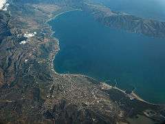
The Bay of Vlorë (Albanian: Gjiri i Vlorës) is a bay of the Ionian Sea in Vlorë, Albania. It is the largest in the country.
Geography
The Bay of Vlorë is surrounded by mainland. In the northwest, it opens to the sea. It is also surrounded in the north by the Narta Lagoon, in the northeast by the city of Vlorë, in the east the foothills of the Ceraunian Mountains, in the south, the small town of Orikum, the Pashaliman Base and the Karaburun peninsula in the southwest.
History
It was a significant region during the antiquity, and was the scene, for example, of some of Caesar's battles. In one account, 18 ships full of merchandise have sunk in the Bay. Studying the Bay of Vlorë, it has been one of the main projects of the navigation department of the University of Vlora in the last few years.[1] The southwestern end of the Bay, at the naval base of Pashaliman, has been used as a harbor since antiquity. The city was called Oricum. During the Cold War, it was temporarily a Soviet naval base, the only one in the Mediterranean sea.
|
See also
References
- ↑ "UNIVERSITETI I VLORES 'Ismail Qemali' – Virtus Scientia Veritas" (PDF). Univlora.edu.al. Archived from the original (PDF) on 2014-02-03. Retrieved 2013-04-22.


