Baruva
| Baruva | |
|---|---|
| village | |
|
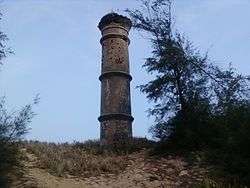
Pillar at Baruva, constructed to commemorate a 1917 shipping accident | |
 Baruva  Baruva Location in Andhra Pradesh, India | |
| Coordinates: 18°32′N 84°21′E / 18.53°N 84.35°ECoordinates: 18°32′N 84°21′E / 18.53°N 84.35°E | |
| Country |
|
| State | Andhra Pradesh |
| District | Srikakulam |
| Elevation | 10 m (30 ft) |
| Languages | |
| • Official | Telugu |
| Time zone | IST (UTC+5:30) |
| PIN | 532263 |
| Vehicle registration | AP-30 |
Baruva is a village and a beach resort located near Sompeta in Srikakulam district, Andhra Pradesh, India. It is located at 18.53N 84.35E.,[1] at an average elevation of 10 m (33 ft). The Mahendratanaya river merges into the Bay of Bengal at this place.
Baruva was used as a seaport in the era of British colonial rule in India up to 1948. In July, 1917, a ship carrying goods sank in the sea. To commemorate this incident a pillar was constructed.[2] The harbor is closed, but the old lighthouse stood until 2000. A light house has been constructed next to the beach resort. Baruva's beach is one of the oldest in Andhra Pradesh.
References
Near the beach are the Durga Baruva railway station is located on Howrah-Chennai mainline. Passenger trains that run from Palasa towards Khurda Road station halt at Baruva station.
References
- ↑ Falling Rain Genomics.Baruva
- ↑ A.P.Tourism.Baruva Beach Archived September 30, 2007, at the Wayback Machine.
