Baruth/Mark
Baruth/Mark is a town in the Teltow-Fläming district of Brandenburg, Germany. It is situated 24 km east of Luckenwalde, and 53 km south of Berlin.
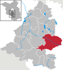
Geography
Baruth/Mark is structured in the following parts of town,[2] which are all villages and mainly former municipalities:
- Baruth/Mark
- Dornswalde
- Groß Ziescht
- Horstwalde
- Klasdorf
- Ließen
- Merzdorf
- Mückendorf
- Paplitz
- Petkus
- Radeland
- Schöbendorf
Demography
Development of Population since 1875 within the Current Boundaries (Blue Line: Population; Dotted Line: Comparison to Population Development of Brandenburg state; Grey Background: Time of Nazi rule; Red Background: Time of Communist rule)
Recent Population Development (Blue Line) and Forecasts
Baruth/Mark:
Population development within the current boundaries (2013)[3]
| Year |
Population |
|---|
| 1875 | 6 513 |
| 1890 | 6 508 |
| 1910 | 6 458 |
| 1925 | 6 312 |
| 1933 | 6 077 |
| 1939 | 6 149 |
| 1946 | 7 626 |
| 1950 | 7 687 |
| 1964 | 5 974 |
| 1971 | 5 620 |
|
|
| Year |
Population |
|---|
| 1981 | 5 229 |
| 1985 | 5 155 |
| 1989 | 5 011 |
| 1990 | 4 926 |
| 1991 | 4 866 |
| 1992 | 4 823 |
| 1993 | 4 786 |
| 1994 | 4 763 |
| 1995 | 4 699 |
| 1996 | 4 766 |
|
|
| Year |
Population |
|---|
| 1997 | 4 843 |
| 1998 | 4 809 |
| 1999 | 4 727 |
| 2000 | 4 651 |
| 2001 | 4 585 |
| 2002 | 4 523 |
| 2003 | 4 515 |
| 2004 | 4 461 |
| 2005 | 4 437 |
| 2006 | 4 388 |
|
|
| Year |
Population |
|---|
| 2007 | 4 360 |
| 2008 | 4 309 |
| 2009 | 4 213 |
| 2010 | 4 174 |
| 2011 | 4 192 |
| 2012 | 4 182 |
| 2013 | 4 171 |
|
|
Photogallery
Sons and daughters of the town
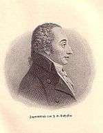
Johann Gottlob Nathusius
References


 Development of Population since 1875 within the Current Boundaries (Blue Line: Population; Dotted Line: Comparison to Population Development of Brandenburg state; Grey Background: Time of Nazi rule; Red Background: Time of Communist rule)
 Recent Population Development (Blue Line) and Forecasts
 Street sign on entry to Baruth/Mark
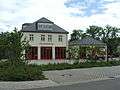 Firehouse
 Castle Baruth
 Fascia detail, Castle Baruth
 Cathedral
 Municipal Playground