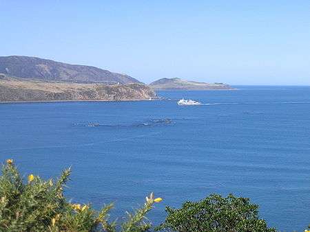
Barrett Reef
The cluster of rocks that is Barrett Reef (often known as Barrett's Reef) is one of the most hazardous reefs in New Zealand.
It lies on the western side of the entrance of Wellington Harbour, on the approaches to the city of Wellington, at coordinates 41°21′9″S 174°50′6″E / 41.35250°S 174.83500°ECoordinates: 41°21′9″S 174°50′6″E / 41.35250°S 174.83500°E. The reef is named after Richard (Dicky) Barrett (1807–1847), a whaler and trader. Its Maori name is Tangihanga-a-Kupe. It is popular with recreational divers.
Dangerous entrance

The reef, much of which is exposed even at high tide, is located to the west of the two-kilometre-wide channel that links Cook Strait with Wellington Harbour, close to the shore of the Miramar Peninsula. Due to the channelling effect of Cook Strait, which lies between the Pacific Ocean and the Tasman Sea, the currents are strong and fickle and gales are common. Add to this the volume of traffic which uses the channel (including several crossings daily of the inter-island ferries to Picton), and it is not surprising that the reef has a lengthy roll-call of shipwrecks.
History of vessels damaged, stranded, or wrecked on Barrett Reef
- 1848 Sobraon, barque, bound for Sydney on Barrett's Reef. This vessel was carrying people away from Wellington on account of the Awatere valley, Marlborough earthquake (7.5)16 Oct 1848; they were fleeing to Sydney.
- 1850 Ship, ' 'Inconstant struck Barrett's Reef. The vessel was afterwards purchased by Mr. John Plimmer and used as a store, called "Noah's Ark," where the Bank of New Zealand stood.
- 1866 Tui, iron steamer. Wrecked, north end of Barrett Reef
- 1871 Lady Bird' ', schooner (3-masted), 303 tons stranded on the south end of Barrett's Reef.
- 1874 Earl of South Esk' ', wooden barque, 336 tons. Became a total loss
- 1874 Cynthia, schooner, 63 tons. Stranded; partial loss. Abreast of north end of Barrett Reef
- 1876 Hunter, schooner, 90 tons. Stranded; total loss. Southernmost rock of Barrett Reef
- 1876 Shepherdess, schooner, 38 tons, Stranded; partial loss
- 1880 ' 'Malay' ', barque, en route from Newcastle. When off Barrett's reef the vessel struck a rock, got off and arrived at port making a little water.
- 1882 ' 'Napier Steamer, 48 tons Barrett's Reef, 8 December 1882; got off.
- 1883 ' 'Caberfeidh, barque, 333 tons, struck outer rock of Barrett's Reef. She received but little injury, only a few feet of her false keel having been carried away.
- 1885 ' 'Corinna, barque 524 tons, stranded on Barrett's Reef when the towing warp parted.
- 1895 ' ' Wakatipu,steamer 1258 tons, and ' 'Flora' ', 838 tons, collided heavily about 200 yards inside the outer rock of Barrett's Reef while racing at top speed. The directors dismissed each master even though they both were credited with great skill and each had many years’ experience under his belt.
- 1897 ' ' Clansman' schooner, 157 tons stranded inside outer reef of on Barrett's Reef, 6 October 1897; got off.
- 1912 ' ' Haupiri, steamer, Barrett's Reef, 17 May 1912; put back to Wellington and beached.
- 1921 Polly Woodside, three-masted iron barque, 678 tons. Stranded; refloated and repaired.
- 1927 Norma
- 1933 ' 'Golden Harvest' ', steamer, 5644 tons, struck the rocks of Barrett’s reef and ran aground.. Stuck fast for 24 hours, then unloaded onto lighters and retrieved by tugs Toia and Terawhiti to Jubilee Floating Dock in Wellington
- 1936 Rangatira, inter-island ferry, 6,152 tons
- 1947 MS Wanganella, liner, 9576 tons. Stranded; refloated and repaired.
- 1968 TEV Wahine, inter-island ferry, 8,948 tons, 53 lives lost. Wrecked; complete loss.
Sources Evening Post, Volume XCIII, Issue 48, 24 February 1917, Page 6 Wanganui Chronicle, Issue 19883, 27 August 1913, Page 5 Evening Post, Volume CXV, Issue 126, 31 May 1933, Page 10
.