Balearic Sea
Coordinates: 40°0′N 1°30′E / 40.000°N 1.500°E


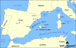
The Balearic Sea (endotoponym: Mar Balear in Catalan and Spanish) is a body of water in the Mediterranean Sea near the Balearic Islands.[1] It is not to be confused with the Alboran sea or the Iberian shelf waters. The Ebro River flows into this small sea.
Extent
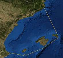
The International Hydrographic Organization defines the limits of the Balearic Sea as follows:[2]
Between the Islas Baleares and the coast of Spain, bounded:
On the Southwest. A line from Cape San Antonio, Spain (38°50′N 0°12′E / 38.833°N 0.200°E) to Cabo Berberia, the Southwest extreme of Formentera (Islas Baleares).
On the Southeast. The South Coast of Formentera, thence a line from Punta Rotja, its Eastern extreme, to the Southern extreme of Isla Cabrera (39°07′N 2°54′E / 39.117°N 2.900°E) and to Isla del Aire, off the Southern extreme of Minorca.
On the Northeast. The East coast of Minorca up to Cap Favaritx (40°00′N 4°14′E / 40.000°N 4.233°E) thence a line to Cabo San Sebastian (Spain) (41°54′N 3°10′E / 41.900°N 3.167°E).
References
- ↑ C.Michael Hogan. 2011. Balearic Sea. Encyclopedia of Earth. Eds. P.Saundry & C.J.Cleveland. National Council for Science and the Environment. Washington DC
- ↑ "Limits of Oceans and Seas, 3rd edition" (PDF). International Hydrographic Organization. 1953. Retrieved 28 October 2016.