Bagulin
| Bagulin | ||
|---|---|---|
| Municipality | ||
| Municipality of Bagulin | ||
|
Bagulin town center | ||
| ||
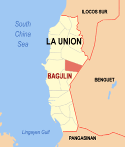 Map of La Union with Bagulin highlighted | ||
.svg.png) Bagulin Location within the Philippines | ||
| Coordinates: 16°36′N 120°26′E / 16.6°N 120.43°ECoordinates: 16°36′N 120°26′E / 16.6°N 120.43°E | ||
| Country |
| |
| Region | Ilocos Region (Region I) | |
| Province | La Union | |
| District | 2nd District | |
| Founded | 1963 | |
| Barangays | 10 (see Barangays) | |
| Government [1] | ||
| • Type | Sangguniang Bayan | |
| • Mayor | Ferdinand Dumaguing Tumbaga | |
| • Electorate | 7,922 voters (2016) | |
| Area [2] | ||
| • Total | 107.33 km2 (41.44 sq mi) | |
| Population (2015 census)[3] | ||
| • Total | 13,456 | |
| • Density | 130/km2 (320/sq mi) | |
| Time zone | PST (UTC+8) | |
| ZIP code | 2512 | |
| PSGC | 013304000 | |
| IDD : area code | +63 (0)72 | |
| Climate type | tropical monsoon climate | |
| Income class | 5th municipal income class | |
| Website |
www | |

Bagulin, officially the Municipality of Bagulin, is a 5th class municipality in the province of La Union, Philippines. According to the 2015 census, it has a population of 13,456 people.[3]
Etymology
Tradition reveals that Bagulin derived its name from a Kankanaey tribal leader. Sometime in the middle of the 18th century, the municipality is part of the township of Allabok which covers the moderate slopes of the mountain ranges overlooking the China Sea. During those times, war tribes was prevalent. Allabok involved itself in a tribal war headed by Bagulin who led the community to victory. From then on until his death, the people highly regarded him as their noble leader. After his death, consensus with the residents together with the concurrence of Spanish authorities resulted in naming the community after Bagulin. At present, Kankanaey still dominate the town’s population.
Another etymological version states that "Bagulin" was derived from the term bago which means "lowland natives". This version is further supported by the fact that Kankanaeys comprise some 85% of the municipal population.
Geography
Bagulin is situated at the interior eastern portion of La Union. It is generally mountainous and forested. It is bounded by the following municipalities:
- North — San Gabriel
- West — City of San Fernando
- Southwest — Naguilian
- South — Burgos
- East — Kapangan
Bagulin is 31 kilometres (19 mi) away from San Fernando, the regional center, 14 kilometres (8.7 mi) away from Naguilian, its nearby town and 62 kilometres (39 mi) away from Baguio City. Its main entrance to lowland municipalities is through the Naguilian-Bagulin Road. It can be reached by vehicles and any regular means of transportation via the town of Naguilian.
Barangays
Bagulin is politically subdivided into 10 barangays. [2]
- Alibangsay
- Baay
- Cambaly
- Cardiz
- Dagup
- Libbo
- Suyo (Poblacion)
- Tagudtud
- Tio-angan
- Wallayan
History
The community was moved to Picdel, a narrow valley strip along Naguilian-Bagulin river. By 1903, the American regime established a paramilitary government and institutional facilities. Education was introduced and a bamboo community hall roofed with cogon was erected. As of 1903, the community was under the jurisdiction of the Mountain Province, sub-province of Benguet with capital at La Trinidad. By 1918, under the agreement of Governor Guzman of Mt. Province and Governor Pio Ancheta of La Union, Bagulin became a municipal district of Burgos under the province of La Union.
By 1928, the community centers was moved to a nearby settlement called Suyo where the present town center is situated. The former community center was named “Nangalisan” which means an abandoned place in the Ilocano dialect. Settlers who improved Suyo were Ilocanos who came from Naguilian. At that time, a bamboo chalet was constructed to serve as an administrative hall. The administration then was composed of the Mayor, a Secretary-Treasurer and one policeman. Municipal income is very small that the administration had to prod reluctant taxpayers to pay their dues.
On June 25, 1963, Bagulin was transformed into a regular, full-pledged municipality by virtue of Executive Order No. 42.
Demographics
| Population census of Bagulin | ||
|---|---|---|
| Year | Pop. | ±% p.a. |
| 1918 | 2,419 | — |
| 1939 | 3,584 | +1.89% |
| 1948 | 3,101 | −1.60% |
| 1960 | 4,407 | +2.97% |
| 1970 | 5,338 | +1.93% |
| 1975 | 6,423 | +3.78% |
| 1980 | 7,009 | +1.76% |
| 1990 | 9,418 | +3.00% |
| 1995 | 10,780 | +2.56% |
| 2000 | 11,857 | +2.06% |
| 2007 | 12,521 | +0.75% |
| 2010 | 12,590 | +0.20% |
| 2015 | 13,456 | +1.27% |
| Source: Philippine Statistics Authority[3][4][5][6] | ||
In the 2015 census, the population of Bagulin was 13,456 people,[3] with a density of 130 inhabitants per square kilometre or 340 inhabitants per square mile.
Gallery
 Municipal hall
 Police station
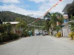
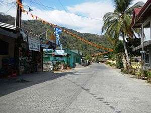 Street view
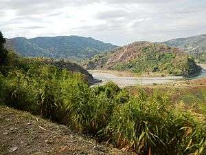 Landscape
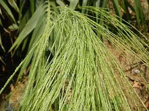 Tiger grass, used for making soft brooms
References
- ↑ "Municipality". Quezon City, Philippines: Department of the Interior and Local Government. Retrieved 31 May 2013.
- 1 2 "Province: La Union". PSGC Interactive. Quezon City, Philippines: Philippine Statistics Authority. Retrieved 12 November 2016.
- 1 2 3 4 Census of Population (2015). "Region I (Ilocos Region)". Total Population by Province, City, Municipality and Barangay. PSA. Retrieved 20 June 2016.
- ↑ Census of Population and Housing (2010). "Region I (Ilocos Region)". Total Population by Province, City, Municipality and Barangay. NSO. Retrieved 29 June 2016.
- ↑ Census of Population (1995, 2000 and 2007). "Region I (Ilocos Region)". Total Population by Province, City and Municipality. NSO. Archived from the original on 24 June 2011.
- ↑ "Province of La Union". Municipality Population Data. Local Water Utilities Administration Research Division. Retrieved 17 December 2016.
External links
| Wikimedia Commons has media related to Bagulin. |
- Municipality of Bagulin
- Philippine Standard Geographic Code
- Philippine Census Information
- Local Governance Performance Management System
| Adjacent places of Bagulin | ||||
|---|---|---|---|---|
 |
San Gabriel | | ||
| San Fernando | |
Kapangan, Benguet | ||
| ||||
| | ||||
| Naguilian | Burgos | |||