Bagh, Dhar
| Bagh बाग باغ बाघ | |
|---|---|
| city | |
 Bagh  Bagh Location in Madhya Pradesh, India | |
| Coordinates: 22°22′N 74°46′E / 22.37°N 74.77°ECoordinates: 22°22′N 74°46′E / 22.37°N 74.77°E | |
| Country |
|
| State | Madhya Pradesh |
| District | Dhar |
| Government | |
| • Type | Sarpanch |
| • Body | Gram panchayat |
| Elevation | 240 m (790 ft) |
| Population (2001) | |
| • Total | 7,415 |
| Languages | |
| • Official | Hindi |
| Time zone | IST (UTC+5:30) |
| PIN | 454221 |
| Telephone code | 07297 |
| ISO 3166 code | IN-MP |
| Vehicle registration | MP-11 |
| Spoken Languages | Hindi, Bhili, Bhilali, Nimadi, English, Khatri |
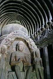
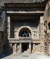
Bagh (Hindi: बाग) is a census town in Dhar district in the state of Madhya Pradesh, India. It is known for the Bagh Caves, which are late 4th- to 6th-century Buddhist rock-cut chambers with murals. The name of the town stems from the caves - according to local legend there were living tigers (bagh in several languages of India) in these abandoned Buddhist caves.[1]
The town is also known for a type of block prints on fabric, known as Bagh prints.
History
In 1982, a hoard of 27 inscriptions issued by the Maharajas of Valkha was discovered at Risawala near Bagh. The inscriptions were issued from a place known as Valkha, which has led to suggestions that the name "Bagh" is derived from "Valkha". The inscriptions are dated to the years 38-134 of an unspecified calendar era. Historians D. C. Sircar and R. C. Majumdar theorized that the Maharajas of Valkha were subordinates to the Guptas, and the calendar era used in their inscription is the Gupta era starting from 319 CE.[2] Thus, the Maharajas of Valkha can be dated to 4th and 5th centuries CE.[3]
The next known ruler of the region is Maharaja Subandhu of Mahishmati. His Bagh Caves inscription is dated 167 (486 CE, assuming Gupta era).[3][4] Historian Walter M. Spink has identified Subandhu as the prince Vishruta mentioned in Dashakumaracharita. According to his theory, Subandhu or Vishruta was a Gupta prince, who established the dynasty that later came to be known as Kalachuri.[5][6]
Notable people from Bagh
- Abdul Kadar Khatri, printer[7][8]
- Mohammed Yusuf Khatri, printer
- Mohammed Bilal Khatri, printer[9][10][11][12]

Transport Connectivity
By Train
Nearest Railway stations are Dahod 100 km., Indore 150 km., Meghnagar 104 km., Ratlam 150 km, Khandwa 220 km.
By Road
Bagh is well connected to Indore Madhya Pradesh by road. Daily Bus Services connects Bagh with Indore 150 km, Dahod 100 km., Ratlam 150 km., Vadodara 220, Khandwa 220 km.
Geography
Bagh is located at 22°22′N 74°46′E / 22.37°N 74.77°E.[13] It has an average elevation of 240 metres (787 feet).
Demographics
As of 2001 India census,[14] Bagh had a population of 7415. Males constitute 51% of the population and females 49%. Bagh has an average literacy rate of 63%, higher than the national average of 59.5%; with 57% of the males and 43% of females literate. 16% of the population is under 6 years of age.
References
- ↑ "Bagh Caves - rock cut Buddhist temples". Retrieved 2010-04-23.
- ↑ Shiv Kumar Tiwari 2002, pp. 63-64.
- 1 2 Archana Verma 2007, p. 23.
- ↑ Walter M. Spink 2005, p. 37.
- ↑ Walter M. Spink 2005, pp. 153-154.
- ↑ Sara L. Schastok 1985, p. 97.
- ↑ "शिल्पकार खत्री को ‘कला निधि’ पुरस्कार". Patrika Newspaper. 19 February 2015. Retrieved 19 March 2017.
- ↑ http://timesofindia.indiatimes.com/city/mumbai/Rare-Kalamkari-Pattachitra-handicrafts-to-go-on-display-Wednesday/articleshow/54784328.cms
- ↑ "Russia awards diploma to Bagh print artist Bilal Khatri". The free press journal. 5 October 2014. Retrieved 10 January 2015.
- ↑ "Vishwakarma award for craftsmen". Times of India. 25 November 2012. Retrieved 11 January 2015.
- ↑ "Celebrating creativity". The Hindu. 21 January 2015. Retrieved 21 January 2015.
- ↑ "Artist Bilal Khatri represents MP for Bagh print in China". The free press journal. 4 November 2014. Retrieved 11 January 2015.
- ↑ Falling Rain Genomics, Inc - Bagh
- ↑ "Census of India 2001: Data from the 2001 Census, including cities, villages and towns (Provisional)". Census Commission of India. Archived from the original on 2004-06-16. Retrieved 2008-11-01.
Bibliography
- Archana Verma (2007). Cultural and Visual Flux at Early Historical Bagh in Central India. Oxford: Archaeopress. ISBN 9781407301518.
- Sara L. Schastok (1985). The Śāmalājī Sculptures and 6th Century Art in Western India. BRILL. ISBN 9789004069411.
- Shiv Kumar Tiwari (2002). Tribal Roots of Hinduism. Sarup & Sons. ISBN 9788176252997.
- Walter M. Spink (2005). Ajanta: The end of the Golden Age. BRILL. ISBN 9789004148321.


