Bagac, Bataan
| Bagac | ||
|---|---|---|
| Municipality | ||
 | ||
| ||
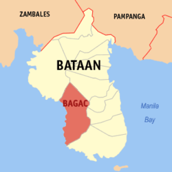 Location within Bataan province | ||
.svg.png) Bagac Location within the Philippines | ||
| Coordinates: 14°36′N 120°24′E / 14.6°N 120.4°ECoordinates: 14°36′N 120°24′E / 14.6°N 120.4°E | ||
| Country | Philippines | |
| Region | Central Luzon (Region III) | |
| Province | Bataan | |
| District | 2nd District | |
| Founded | 1866 | |
| Barangays | 14 (see Barangays) | |
| Government [1] | ||
| • Type | Sangguniang Bayan | |
| • Mayor | Louise Gabriel Q. Del Rosario (NUP) | |
| • Vice Mayor | Ron Michael Alexis R. Del Rosario (NUP) | |
| Area [2] | ||
| • Total | 231.20 km2 (89.27 sq mi) | |
| Population (2015 census)[3] | ||
| • Total | 26,936 | |
| • Density | 120/km2 (300/sq mi) | |
| • Voter (2016)[4] | 22,230 | |
| Time zone | PST (UTC+8) | |
| ZIP code | 2107 | |
| IDD : area code | +63 (0)47 | |
| Income class | 3rd class | |
| PSGC | 030802000 | |

Bagac, officially the Municipality of Bagac (Filipino: Bayan ng Bagac; Kapampangan: Balen ning Bagac), is a municipality in the province of Bataan in the Central Luzon (Region III) of the Philippines. The population was 26,936 at the 2015 census.[3] In the 2016 electoral roll, it had 22,230 registered voters.[4]
With an area of 231.20 square kilometres (89.27 sq mi),[5] Bagac is the largest municipality in Bataan.
Geography
Bagac is located at 14°36′N 120°24′E / 14.6°N 120.4°E.
According to the Philippine Statistics Authority,[6] the municipality has a land area of 231.20 square kilometres (89.27 sq mi) [2] constituting 16.84% of the 1,372.98-square-kilometre- (530.11 sq mi) total area of Bataan.
Barangays
Bagac is politically subdivided into 14 barangays.[5]
| PSGC | Barangay | Population | ±% p.a. | |||
|---|---|---|---|---|---|---|
| 2015[3] | 2010[7] | |||||
| 030802016 | Atilano L. Ricardo | 9.1% | 2,447 | 2,224 | 1.84% | |
| 030802001 | Bagumbayan (Poblacion) | 7.3% | 1,978 | 1,766 | 2.18% | |
| 030802002 | Banawang | 10.3% | 2,784 | 2,690 | 0.66% | |
| 030802003 | Binuangan | 2.3% | 613 | 609 | 0.12% | |
| 030802004 | Binukawan | 8.7% | 2,356 | 2,293 | 0.52% | |
| 030802006 | Ibaba | 6.3% | 1,689 | 1,760 | −0.78% | |
| 030802007 | Ibis | 6.2% | 1,660 | 1,407 | 3.20% | |
| 030802008 | Pag‑asa (Wawa‑Sibacan) | 12.1% | 3,271 | 3,456 | −1.04% | |
| 030802009 | Parang | 12.1% | 3,248 | 3,073 | 1.06% | |
| 030802010 | Paysawan | 2.7% | 731 | 680 | 1.39% | |
| 030802012 | Quinawan | 2.1% | 574 | 553 | 0.71% | |
| 030802013 | San Antonio | 5.4% | 1,445 | 1,295 | 2.11% | |
| 030802014 | Saysain | 10.6% | 2,859 | 2,539 | 2.29% | |
| 030802015 | Tabing‑Ilog (Poblacion) | 4.8% | 1,281 | 1,223 | 0.89% | |
| Total | 26,936 | 25,568 | 1.00% | |||
Demographics
| Population census of Bagac | ||
|---|---|---|
| Year | Pop. | ±% p.a. |
| 1903 | 1,310 | — |
| 1918 | 2,118 | +3.25% |
| 1939 | 2,958 | +1.60% |
| 1948 | 2,745 | −0.83% |
| 1960 | 6,889 | +7.97% |
| 1970 | 9,268 | +3.01% |
| 1975 | 10,676 | +2.88% |
| 1980 | 13,109 | +4.19% |
| 1990 | 18,241 | +3.36% |
| 1995 | 20,906 | +2.59% |
| 2000 | 22,353 | +1.45% |
| 2007 | 24,202 | +1.10% |
| 2010 | 25,568 | +2.02% |
| 2015 | 26,936 | +1.00% |
| Source: Philippine Statistics Authority[3][7][8][9] | ||
In the 2015 census, Bagac had a population of 26,936.[3] The population density was 120 inhabitants per square kilometre (310/sq mi).
In the 2016 electoral roll, it had 22,230 registered voters.[4]
Attractions
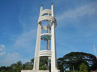
- Bagac Friendship Tower. — The monument, symbolizing the renewed friendship between Japan and the Philippines after the events of World War II, was erected by Risshō Kōsei Kai, a Japanese Buddhist organization. The tower was inaugurated on April 8, 1975 and is located about 200 m (660 ft) from where the Bataan Death March started. The 27-metre-high (89 ft) tower is composed of three pillars interconnected by several multi-layer rings. It located at the junction of the Gov. Linao National Road and the road to the Bagac town proper.[10]
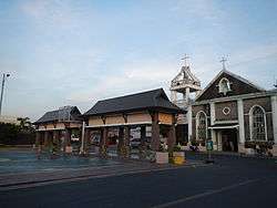
- Las Casas Filipinas de Acuzar. — a heritage park built by José "Gerry" Acuzar, owner of the New San Jose Builders and history art collector. Inside this heritage park is a collection of Spanish Colonial buildings and stone houses (bahay na bato in Tagalog), planned to resemble a settlement reminiscent of the period. These houses were carefully transplanted from different parts of the Philippines and rehabilitated to their former splendor.
Popular culture
- The Ciudad Real de Acuzar Heritage Park was the location of the TV Show Zorro of GMA Network.
Gallery
|


References
- ↑ "Municipality". Quezon City, Philippines: Department of the Interior and Local Government. Retrieved 31 May 2013.
- 1 2 "Province: Bataan". PSGC Interactive. Quezon City, Philippines: Philippine Statistics Authority. Retrieved 12 November 2016.
- 1 2 3 4 5 Census of Population (2015). "Region III (Central Luzon)". Total Population by Province, City, Municipality and Barangay. PSA. Retrieved 20 June 2016.
- 1 2 3 "2016 National and Local Elections Statistics". Commission on Elections. 2016.
- 1 2 "Municipal: Bagac, Bataan". PSGC Interactive. Quezon City, Philippines: Philippine Statistics Authority. Retrieved 8 January 2016.
- ↑ http://www.bataan.gov.ph/home/government/provincial-government-offices/local-government-unit/municipality-city/bagac.html
- 1 2 Census of Population and Housing (2010). "Region III (Central Luzon)". Total Population by Province, City, Municipality and Barangay. NSO. Retrieved 29 June 2016.
- ↑ Census of Population (1995, 2000 and 2007). "Region III (Central Luzon)". Total Population by Province, City and Municipality. NSO. Archived from the original on 24 June 2011.
- ↑ "Province of Bataan". Municipality Population Data. Local Water Utilities Administration Research Division. Retrieved 17 December 2016.
- ↑ "Friendship Tower in the Philippines". Rissho Kosei-kai. Archived from the original on July 30, 2007. Retrieved September 9, 2007.
External links
| Wikimedia Commons has media related to Bagac, Bataan. |
- Bagac Bataan General Information on MyBataan
| Adjacent places of Bagac, Bataan | ||||
|---|---|---|---|---|
 |
Morong | |
Balanga | |
| Bagac Bay (South China Sea) | |
Pilar Orion Limay | ||
| ||||
| | ||||
| Mariveles | ||||
Balanga (capital) | |
| Municipalities | |
| Component city | |