Ba'a
| Ba'a | |
|---|---|
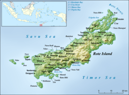 Map of Roti Island | |
 Ba'a Map of Roti Island | |
| Coordinates: 10°43′35.015732″S 123°2′52.303391″E / 10.72639325889°S 123.04786205306°ECoordinates: 10°43′35.015732″S 123°2′52.303391″E / 10.72639325889°S 123.04786205306°E | |
| Country | Indonesia |
| Province | East Nusa Tenggara |
| Regency | Rote Ndao Regency |
| District | Lobalain |
| Population (2010) | |
| • Total | 1,161 |
Ba'a (Baa, Baadale) is the capital of the Indonesian island of Roti and the governmental district Rote Ndao, province of East Nusa Tenggara.[1] It lies in the district (kecamatan) Lobalain and forming a village (desa) with 1,161 inhabitants (2010).[2]
Notes
- ↑ Map of Roti
- ↑ "Archived copy" (PDF). Archived from the original on 2012-10-12. Retrieved 2014-04-24. (Indonesian; PDF; 6,0 MB), accessed January 26, 2013
This article is issued from
Wikipedia.
The text is licensed under Creative Commons - Attribution - Sharealike.
Additional terms may apply for the media files.