Baía do Galeão
| Baía do Galeão | |
|---|---|
|
Baía do Galeão, its location is in the northeast of the island | |
| Location | Northwest of Maio, Cape Verde |
| Coordinates | 15°19′N 23°9′W / 15.317°N 23.150°WCoordinates: 15°19′N 23°9′W / 15.317°N 23.150°W |
| Max. length | 5 km |
| Max. width | 2 km |

Baía do Galeão is a bay on the north coast of the island of Maio in Cape Verde. The nearest village is Cascabulho, 5 km to the south.
A part of the bay are shallow and contains rocks. Somewhat 5,000 to 4,000 years ago, they were land mass in the Late Ice Age.
The bay was mentioned as "Ghelloons" in the 1747 French/Dutch map by Jacques Nicolas Bellin.[1]
References
- ↑ Jacques-Nicolas Bellin; Pieter de Hondt (1747). "Carte des Isles du Cap Verd = Kaart van de Eilanden van Kabo Verde" (in French).
The island of Maio and the surrounding islands | ||
|---|---|---|
| Communities and settlements | 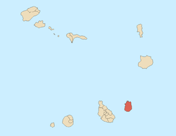 | |
| Parishes | ||
| Mountains | ||
| Other geographical features | ||
This article is issued from
Wikipedia.
The text is licensed under Creative Commons - Attribution - Sharealike.
Additional terms may apply for the media files.