BT Tower (Birmingham)
| BT Tower | |
|---|---|
|
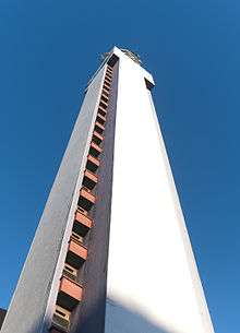
BT Tower as seen from Snow Hill Rail Station | |
| General information | |
| Type | Telecommunication |
| Location | 40 Lionel Street, Birmingham, England |
| Coordinates | 52°29′0.31″N 1°54′15.95″W / 52.4834194°N 1.9044306°WCoordinates: 52°29′0.31″N 1°54′15.95″W / 52.4834194°N 1.9044306°W |
| Construction started | July 1963 |
| Completed | September 1966 |
| Height | |
| Roof | 152 metres (499 ft) to top of crane |
| Technical details | |
| Floor count | 31 |
| Design and construction | |
| Architect | Ministry of Public Buildings and Works |
| References | |
| [1] | |
The BT Tower (formerly known as the Post Office Tower and, before that, the GPO Tower) is a famous landmark and telecommunications tower in Birmingham, England, and is also the tallest structure in the city. Its Post Office code was YBMR.
History
Construction of the tower commenced in July 1963 and was completed in September 1965. The tower became operational in December 1966 and was officially opened by the Lord Mayor of Birmingham, Alderman James S. Meadows on 5 October 1967.[2] It was designed by the Ministry of Public Building and Works with M.H. Bristow being the senior architect.[3] It has 26 storeys, housing technical areas and offices, and five levels of circular aerial galleries at the top.[4]

The original intention was to build a circular tower similar to the London one but without the public floors above the aerial galleries. At one time the Post Office wanted to increase the height from 500 feet (150 m), which had been agreed by the Ministry of Aviation, to 600 feet (180 m). This was refused in order to avoid non-standard procedures for aircraft approaching Birmingham Airport from the north-west. Cost over-runs on the London tower led to a review of the Birmingham design, and then it was decided to use a circular design of the 'Chilterns' type as used at Stokenchurch, Charwelton, Pye Green, Sutton Common, Heaton Park and Tinshill radio stations, but with the internal diameter increased from 32 feet (9.8 m) to 37 feet (11 m) to provide sufficient space on the equipment floors. The square design, as built, was proposed for aesthetic reasons by the Chief Architect of the Ministry of Public Building and Works.[4]
The tower was designed to be stable in high winds. Channels at each corner funnel the wind to counteract the force of the wind swaying the structure. A stable platform is necessary so that the microwave dishes mounted on the side of the structure keep line of sight with the remote transmitter they are communicating with.
There were two steel rails on one wall on which a trolley was designed to run to carry the dishes up to the aerial galleries. The original horn dishes were too heavy for the roof mounted crane to lift and had to be stripped down, even in this state they were only just under the crane's maximum load capacity.
The ability to lift dishes was dependent on the weather and to complicate matters, the steel rails only went to the bottom of the first aerial gallery. To get the dishes higher a steel cable system was used that was mounted on poles. When the trolley reached the aerial gallery it had to be disconnected from the rails and swung out to attach to the cables.
In August 2003, the tower was painted an ultramarine blue to cover the existing light brown which had started to discolour. The balconies were painted to stand out from the tower in a dark shade of blue. On 18 March 2004, Jasper Carrott switched on the night time illuminations of the tower in response to Birmingham City Council's policy of encouraging the illumination of local landmarks.[2]
The tower is home to a pair of peregrines, with a webcam installed in 2010.[5]
On 5 February 2012 the last of the large analogue aerial dishes was removed following a migration to digital transmission. Around eighty smaller dishes remain.[6]
Floors
There are 24 equipment height floors (10ft 6in height), a Band Branching area (Floor 25) - the square section seen from outside which is approximately double the normal floor height followed by 5 aerial galleries.
Floor numbering used YBMR/A followed by the actual floor number +1, i.e. the Ground Floor was YBMR/A1 etc. The aerial galleries were labelled YBMR/B1-5.
See also
References
- ↑ BT Tower (Birmingham) at Emporis
- 1 2 "BT's towering achievement". Birmingham Post. 2006-09-08. Retrieved 2007-12-08.
- ↑ Foster, Andy (2007) [2005]. Birmingham. Pevsner Architectural Guides. Yale University Press. p. 190. ISBN 978-0-300-10731-9.
- 1 2 Hanman, B.L.G., and Smith, N.D. (1965), Birmingham Radio Tower, The Post Office Electrical Engineers' Journal, Vol. 58 Part 3, October 1965, pp. 182-186.
- ↑ "BBC - Live Peregrine Falcon cam - BT Tower, Birmingham". BBC Online. BBC. 11 May 2010. Archived from the original on 16 May 2010. Retrieved 31 May 2010.
- ↑ "Workmen remove last analoguie dish from BT Tower in Birmingham". Birmingham Mail. Retrieved 1 June 2012.
| Wikimedia Commons has media related to BT Tower, Birmingham. |