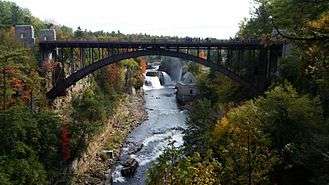
Ausable Chasm (New York)


Ausable Chasm is a sandstone gorge and tourist attraction located near the hamlet of Keeseville, New York, United States.[1] It is directly due west of Port Kent. The Ausable River runs through it and then empties into Lake Champlain. The gorge is about two miles (3.2 km) long and is a tourist attraction in the Adirondacks region of Upstate New York. It is fed by the Rainbow Falls at its southern extreme.
Geological formation
Geologically, the gorge is fairly simple. The Ausable River carved a gorge a little over one mile (1.6 km) long down through the 500-million-years-old Cambrian-Period Potsdam Sandstone since the end of the Pleistocene Epoch ice age around 10,000 years ago. The headward erosion of ancestral Rainbow Falls led to its location today near the visitor's center.[2]
Ausable Chasm was first seen by non-Native Americans in 1765 and, since then, has been a draw to tourists in the eastern Adirondacks. The chasm has a continuous exposure of a section of the Potsdam Sandstone more than 520 feet (160 m) thick, which includes a rare, mid-Cambrian jellyfish fossil.[3]
Some of the rock formations have been given names such as Cathedral, The Devil's Oven, Elephant's Head, The Flume, Sentinel Rock, and Table Rock.
Tourism
In 1760, Major John Howe explored the chasm on ropes. Called by some the "Little Grand Canyon of the East", the 1.5-mile-long (2.4 km) chasm opened to the public in 1870.[4]
Cultural attractions
- North Star Underground Railroad Museum, commemorating the Underground Railroad and operated by the North Country Underground Railroad Historical Association, is on Mace Chasm Road in Ausable Chasm, New York on County Route 71, south of the junction of County Route 373 and U.S. 9.[5]
Gallery
- Pictures from 1907 postcards
- Lookout Point
- Rainbow Falls
- Hotel Ausable Chasm
References
- ↑ "AuSable Chasm". Amazing Adirondack Wonders. Adirondack Wilderness Foundation,. 2011. ISBN 9781458364159.
- ↑ "Ausable Chasm". Hudson Valley Geologist. November 2013.
- ↑ Hagadorn, James W. & Belt, Edward S. (2008). "Stranded in Upstate New York: Cambrian Scyphomedusae from the Potsdam Sandstone" (PDF). Palaios. 23: 424–441. doi:10.2110/palo.2006.p06-104r.
- ↑ "Ausable Chasm". Fodor's.
- ↑ "North Star Underground Railroad Museum". northcountryundergroundrailroad.com.
External links
| Wikimedia Commons has media related to Ausable Chasm. |
Coordinates: 44°31′45″N 73°27′40″W / 44.52917°N 73.46111°W