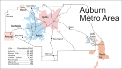
Auburn, Alabama, metropolitan area
Coordinates: 32°37′54.69″N 85°28′54.74″W / 32.6318583°N 85.4818722°W
| Auburn Metropolitan Area | |
|---|---|
| Auburn-Opelika | |
 | |
| Coordinates: 32°37′55″N 85°28′55″W / 32.6319°N 85.4819°W | |
| Country | United States |
| State(s) | Alabama |
| Largest city | Auburn |
| Other cities | - Opelika |
| Highest elevation | 928 ft (283 m) |
| Lowest elevation | N/A ft (N/A m) |
| Population (2016 est.) | |
| • Total | 158,991 |
| • Rank | 259th in the U.S. |
The Auburn Metropolitan Area—officially the Auburn-Opelika, Alabama Metropolitan Statistical Area[1][2][3]—is a metro area in east-central Alabama with a 2016 population of 158,991. It was the 19th fastest growing metro area in the United States between 1990 and 2000. The Auburn Metro area consists of Lee County, and includes the cities of Auburn (population 63,118), Opelika (population 27,443), and the northernmost portion of Phenix City (population 31,100).
Incorporated Communities
- Auburn, Alabama
- Loachapoka, Alabama
- Notasulga, Alabama (part)
- Opelika, Alabama
- Phenix City, Alabama (part)
- Smiths Station, Alabama
- Waverly, Alabama (part)
Unincorporated Communities
- Beauregard, Alabama
- Bee Hive, Alabama
- Beulah, Alabama
- Gold Hill, Alabama
- Marvyn, Alabama
- Salem, Alabama
- The Bottle, Alabama
See also
References
- ↑ {{cite web|url=https://factfinder.census.gov/faces/tableservices/jsf/pages/productview.xhtml?src=bkmk |title=Annual Estimates of the Resident Population: April 1, 2010 to July 1, 2016 - United States -- Metropolitan and Micropolitan Statistical Area; and for Puerto Rico |accessdate=2017-05-28 |
- ↑ "Archived copy". Archived from the original on June 25, 2009. Retrieved 2009-06-25.
- ↑ http://www.interstate-guide.com/i-085.html
This article is issued from
Wikipedia.
The text is licensed under Creative Commons - Attribution - Sharealike.
Additional terms may apply for the media files.

