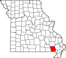
Ash Hill Township, Butler County, Missouri
| Ash Hill Township | |
|---|---|
| Township | |
 | |
| Coordinates: 36°40′16″N 090°15′05″W / 36.67111°N 90.25139°WCoordinates: 36°40′16″N 090°15′05″W / 36.67111°N 90.25139°W | |
| Country | United States |
| State | Missouri |
| County | Butler |
| Area | |
| • Total | 131.15 sq mi (339.69 km2) |
| • Land | 130.88 sq mi (338.98 km2) |
| • Water | 0.27 sq mi (0.7 km2) 0.21% |
| Elevation[1] | 318 ft (97 m) |
| Population (2000) | |
| • Total | 3,514 |
| • Density | 26.8/sq mi (10.4/km2) |
| FIPS code | 29-02224[2] |
| GNIS feature ID | 0766348 |
Ash Hill Township is one of ten townships in Butler County, Missouri, USA. As of the 2000 census, its population was 3,514.
Geography
Ash Hill Township covers an area of 131.15 square miles (339.7 km2) and contains two incorporated settlements: Fisk and Qulin. It contains six cemeteries: Ash Hills, Browns, Hillis, Kelly, Qulin and Vale.
The streams of Blue Spring Slough, Catherine Slough, Cross Slough, Dan River, Lake Slough, Menorkenut Slough Number 16 and Menorkenut Slough Number 19 run through this township.
References
- ↑ "US Board on Geographic Names". United States Geological Survey. 2007-10-25. Retrieved 2008-01-31.
- ↑ "American FactFinder". United States Census Bureau. Archived from the original on 2013-09-11. Retrieved 2008-01-31.
External links
This article is issued from
Wikipedia.
The text is licensed under Creative Commons - Attribution - Sharealike.
Additional terms may apply for the media files.
