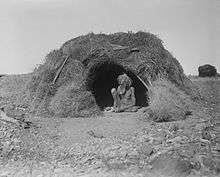
Arltunga Historical Reserve
.jpg)
Arltunga is a deserted gold rush town located 110 km (68 miles) east of Alice Springs, in the Northern Territory of Australia. It is of major historical significance as the first major European settlement in Central Australia.[1]
Early Indigenous history

The Karo:linga and Aldolanda people, now known as the East Aranda people are thought to have occupied the Arltunga and surrounding region for up to 20,000 years. An early map drawn by TGH Strehlow identifies at least thirty significant cultural sites in the region surrounding Arltunga, including water sources that would have supported early mining in the region. While much mythological ceremonial information remains sacred, it is widely known that the Kulaia serpent inhabits all places containing water. When Strehlow camped just south of Arltunga in 1935, he recorded other Eastern Aranda kangaroo, native cat and rain ceremonies and songs. While most the Easter Arnada people left the region in 1953 upon the establishment of the Santa Teresa Mission, they returned regularly for ceremonies well into the 1970s. Rock carvings and artifacts have been found in the Arltunga area, particularly near Paddy's Rock-Hole, Akura-ala Waterhole and the Joker's Mine Area and Gorge.[2]
Mining
Gold was observed by South Australian explorer, David Lindsay in 1887 as he trekked from Port Darwin to the coast of South Australia. Subsequently, miners flocked to the area and Arltunga became the first substantial European settlement in Central Australia.[3] The town was kept alive for a while after the initial gold rush when the South Australian Government built the Government Battery and Cyanide Works in 1898, but with the Battery's closure in 1916, the population declined to 25 by 1933.[4]
Mission
A mission for Aboriginal people called the Sacred Heart Mission was established at Arltunga in 1935 by Father P. Moloney.[5] It was moved to a more 'suitable' site at Phillipson's Block (Santa Teresa) southeast of Alice Springs in 1952.[6]
Recent history
Arltunga Historical Reserve was established in 1975 and comprises 5,000 ha.[3] Owing to the harshness of the climate and the fact that local stone was used in the construction of buildings, the town is well preserved.[4]
The reserve was nominated for heritage listing in 2008. While the Government Battery and Cyanide Works site at Arltunga was successfully listed in 1995, the nomination for the rest of the reserve was unresolved due to a native title claim in the area until 2014, when a second nomination was successful.[7][8][9]
References
- ↑ "Arltunga Historical Reserve" (PDF). Parks and Wildlife Commission NT. Parks and Wildlife Commission of the Northern Territory. Archived from the original (PDF) on 28 February 2015. Retrieved 1 May 2015.
- ↑ Service Enterprises Pty Ltd (1982). Arltunga Historic Reserve: A Pilot Study for the Initiation of Recommended Conservation Action and Presentation at Selected Historic Sites. The Conservation Commission of the Northern Territory – via Northern Territory Library.
- 1 2 "Arltunga". Sydney Morning Herald. 2 May 2008. Retrieved 1 May 2015.
- 1 2 "Arltunga, NT". Aussie Towns. Retrieved 1 May 2015.
- ↑ ""ONE OF THE MOST REMARKABLE EVENTS IN THE HISTORY OF THE CHURCH IN AUSTRALIA HAS BEEN THE WAY THE BLACKS OF THE CENTRE HAVE ACCPETED THE FAITH AND LET IT SINK DEEP INTO THEIR HEARTS"—(Ft. T.) FATHER MOLONEY'S "HUNCH" HAS PAID OFF". The Southern Cross. LXIV, (3247). South Australia. 12 December 1952. p. 11. Retrieved 17 July 2016 – via National Library of Australia.
- ↑ "Native Mission Moves to Better Site". Advocate. LXXXV, (5064). Victoria, Australia. 14 August 1952. p. 8. Retrieved 17 July 2016 – via National Library of Australia.
- ↑ "Arltunga Historical Reserve". Heritage Register. Northern Territory Government. Retrieved 2 January 2017.
- ↑ "Government Battery and Cyanide Works, Arltunga". Heritage Register. Northern Territory Government. Retrieved 2 January 2017.
- ↑ "Arltunga Historical Reserve - renominated 2014". Heritage Register. Northern Territory Government. Retrieved 2 January 2017.
Coordinates: 23°26′50″S 134°43′00″E / 23.44722°S 134.71667°E