Arlington Heights (Pittsburgh)
| Arlington Heights | |
|---|---|
| Neighborhood of Pittsburgh | |
 | |
| Coordinates: 40°24′54″N 79°58′12″W / 40.415°N 79.970°W | |
| Country | United States |
| State | Pennsylvania |
| County | Allegheny County |
| City | Pittsburgh |
| Area[1] | |
| • Total | 0.132 sq mi (0.34 km2) |
| Population (2010)[2] | |
| • Total | 244 |
| • Density | 1,800/sq mi (710/km2) |
| ZIP Code | 15210 |
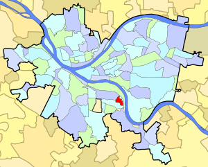
Arlington Heights is a neighborhood in the southern portion of Pittsburgh, Pennsylvania. The zip code used by residents is 15210, and this neighborhood is represented on the Pittsburgh City Council by the council member for District 3 (Central South Neighborhoods). This neighborhood is home to five government housing projects.
Twenty Second Street Incline
Arlington Heights was once connected to the mills along the Monongahela River by the Twenty Second Street Incline, which ran from Josephine Street to Salisbury Street, near the location of Fort McKinley. [3] [4] [5]
Surrounding Pittsburgh neighborhoods
References
- ↑ "Census: Pittsburgh" (PDF). Pittsburgh Department of City Planning. January 2006. Archived from the original (PDF) on 2007-08-10. Retrieved 2007-07-19.
- ↑ "Census: Pittsburgh". Pittsburgh Department of City Planning. April 2013. Retrieved 2013-04-26.
- ↑ Fleming, George T (1922). History of Pittsburgh and environs, from prehistoric days to the beginning of the American Revolution ... New York, Chicago: American Historical Society. pp. 169, 219.
- ↑ Boehmig, Stuart P (2006-04-19). Pittsburgh's South Side. p. 115. ISBN 978-0-7385-3939-3. Retrieved 2009-05-12.
- ↑ "With New Engineers" (PDF). Pittsburgh Post. 1889-04-22. Retrieved May 13, 2009. Pittsburgh Post
Further reading
- Toker, Franklin (1994) [1986]. Pittsburgh: An Urban Portrait. Pittsburgh: University of Pittsburgh Press. ISBN 0-8229-5434-6.
See also
External links
This article is issued from
Wikipedia.
The text is licensed under Creative Commons - Attribution - Sharealike.
Additional terms may apply for the media files.