Arkansas Highway 206
| ||||
|---|---|---|---|---|
 | ||||
| Route information | ||||
| Maintained by AHTD | ||||
| Section 1 | ||||
| Length: | 20.70 mi[1] (33.31 km) | |||
| West end: |
| |||
| East end: |
| |||
| Section 2 | ||||
| Length: | 3.00 mi[1] (4.83 km) | |||
| West end: |
| |||
| East end: |
| |||
| Location | ||||
| Counties: | Boone, Marion | |||
| Highway system | ||||
| ||||
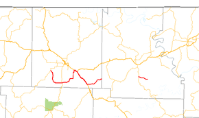
Arkansas Highway 206 is a designation for two east–west state highways in north Arkansas. The longer segment of 20.70 miles (33.31 km) runs from Highway 43 in Boone County to the Marion County line.[1] A shorter segment of 3.00 miles (4.83 km) runs east from Highway 14 to Marion County Route 6022.[2] Neither route has any spur or business routes.[1]
Route description
Boone County
The route begins at Highway 43 and heads southeast to meet with AR 7. The route continues north to US 62/US 65/US 412 in Bellefonte. Highway 206 curves southeast with US 65 to Valley Springs. After Valley Springs, the highway trails east and terminates at the Marion County line.
Marion County
Highway 206 in Boone County begins at Highway 14 at Ralph and runs east. State maintenance ends at a county blacktop, CR 6022.
Major intersections
Mile markers reset at concurrencies.
| County | Location | mi[1] | km | Destinations | Notes |
|---|---|---|---|---|---|
| Boone | | 0.0 | 0.0 | western terminus | |
| | 7.21 | 11.60 | |||
| Bellefonte | 14.90 | 23.98 | |||
| | |||||
| | 0.0 | 0.0 | |||
| Boone–Marion county line | | 5.80 | 9.33 | eastern terminus | |
| Highway 206 eastern segment begins in Marion County | |||||
| Marion | | 0.0 | 0.0 | western terminus | |
| | 3.00 | 4.83 | eastern terminus | ||
| 1.000 mi = 1.609 km; 1.000 km = 0.621 mi | |||||
References
Route map: Google
- 1 2 3 4 5 Planning and Research Division (2010). "Arkansas Road Log Database". Arkansas State Highway and Transportation Department. Archived from the original (Database) on 23 June 2011. Retrieved June 9, 2011.
- ↑ Route and Section Map (PDF) (Map). Arkansas State Highway and Transportation Department. Retrieved June 9, 2011.
