Geography of Albania
 | |
| Continent | Europe |
|---|---|
| Region | Southern Europe |
| Coordinates | 41°00′N 20°00′E / 41.000°N 20.000°E |
| Area | Ranked 145 |
| • Total | 28,748 km2 (11,100 sq mi) |
| • Land | 97,70% |
| • Water | 2,30% |
| Coastline | 427 km (265 mi) |
| Borders |
Greece 212 km (132 mi), Montenegro 186 km (116 mi), Macedonia 181 km (112 mi), Kosovo[a] 112 km (70 mi) |
| Highest point | Mount Korab, 2,764 m (9,068 ft) |
| Lowest point | Adriatic Sea, 0 m |
| Longest river | Drin River, 335 km (208 mi) |
| Largest lake | Lake Shkodër 530 km2 (200 sq mi) |
The Geography of Albania is defined by its location. Albania is a small predominantly mountainous country in Southeastern Europe, on facing the Adriatic and Ionian seas within the Mediterranean Sea. Albania covers a territory of 28,748 km2 (11,100 sq mi), making it the 145th largest country in the world.[1][2] It shares borders with Montenegro in the northwest, Kosovo in the northeast, Macedonia in the east and Greece in the south.[3] It's coastline length on the Adriatic and the Ionian Seas is 476 km (296 mi).[4] The lowlands of the west face the Adriatic Sea and the strategically important Strait of Otranto, which puts less than 72 km (45 mi) of water between Albania and the heel of the Italian coast.
Albania is distinguished for its rich biological diversity.[5] Due to its climatic, hydrological, geological and topographical conditions, Albania is host to 30% of the entire flora and 42% of fauna of Europe.[6][7] There are 799 Albanian protected areas covering a surface of 4,600.61 square kilometres. These include 15 national parks, 5 protected landscape areas, 29 nature reserves, 4 protected resource areas and 750 natural monuments.[8] The national parks covering a surface area of 210,668.48 hectares (2,106.6848 km2) or roughly 13.65% of the overall territory.[9] The nation host also 8 archaeological parks covering a surface area of 1,120 hectares (11.2 km2).
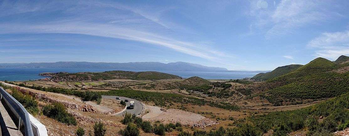
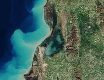
Albania is home to the largest lake in Southern Europe; the Lake Shkodër.[10] Geographically, it is located on the border between Albania and Montenegro, with an area that seasonally can vary between 370 km2 (140 sq mi) to 600 km2 (230 sq mi). One third belongs to Albania. The Albanian shoreline of the lake is 57 km (35 mi). However, the Lake Ohrid is the deepest lake 288 m (945 ft) in the Balkans, the oldest lake in Europe and one of the most ancient in the world.[11][12]. Due to its natural and historical value, the Ohrid-Prespa Transboundary Reserve was added to UNESCO's World Network of Biosphere Reserves.
In 2016, Albania had a population of 2.87 million (1,46 million males and 1,42 million females), ranking 136th in the world by population. The population density was 101 inhabitants per square kilometre.[13] The overall life expectancy in Albania at birth is 78 years.[14] The total fertility rate of 1.80 children per mother is one of the lowest in the world. In 2016, the population of Albania was about 2,89 million, comprising 1,447 million male and 1,443 female persons.[15] There were 38,003 live births and 20,737 deaths in Albania. The natural increase of the population was positive, as the number of births exceeded the number of deaths by 17,266. Due to external migration, the population declined by 18,307. The total dependency ratio of population in Albania is 46.8 %.
Boundaries and territory
With a surface of 28.748 square kilometres (11.100 sq mi), Albania is placed along the eastern part of the Adriatic Sea and the Ionian Sea within the Mediterranean sea. It has a length of borders about 1094 kilometres, 657 kilometres (408 mi) of which are terrestrial, 316 kilometres (196 mi) of shore border, 48 kilometres (30 mi) river borders and 73 kilometres (45 mi) lake borders. Inland water surface is 1,350 square kilometres (520 sq mi), composed by natural lakes 325 square kilometres (125 sq mi), coastal lagoons 130 square kilometres (50 sq mi), artificial lakes 174 square kilometres (67 sq mi) and river network 721 kilometres (448 mi).[16] With the exception of the coastline, all Albanian borders are artificial. They were established at the 1912-1913 Conference London. The country was occupied by several forces during first World War, but the 1913 boundaries were essentially reaffirmed by the victorious states in 1921. Division of the lake district among three states required that each of them have a share of the lowlands in the vicinity. Such an artificial distribution, once made, necessarily affected the borderlines to the north and south. The border that runs generally north from the lakes, although it follows the ridges of the eastern highlands, stays sixteen to 32 kilometres (20 mi) west of the watershed divide. Due to negotiators at the Conference of London declined to use the watershed divide as the northeast boundary of the new state of Albania, the Albanian population of Kosovo was incorporated into Serbia.

The northern border is 287 kilometres (178 mi) long, of them 173 kilometres (107 mi) are with Montenegro and 114 kilometres (71 mi) with Kosovo.[17] In the north and the northeast mountainous sections, the border connects high points and follows mountain ridges through the largely inaccessible Albanian Alps. For the most part, there is no natural boundary from the highlands to the Adriatic, although Lake of Shkodër, which is the largest lake in Southern Europe, and a portion of the Buna River south of it were used to mark the northwest border with Montenegro. The eastern border with the Republic of Macedonia is 151 kilometres (94 mi) long. The Albania–Macedonia frontier runs from the Dibër valley in the east; to the north it is the Korab range, containing Mount Korab 2,764 metres (9,068 ft) the highest point in both countries, through the Elbasan County, crosses the Lake of Ohrid and ends at the Lake of Prespa in the Korçë County. However, the Mount Korab is the highest peak of the European Green Belt.[18] The southern and southeastern border with Greece is 282 kilometres (175 mi).[19] The Gramos mountain range forms the border with Greece. The western border 446 kilometres (277 mi) is maritime and encompasses the Albanian Adriatic Sea Coast from Buna river in the north near the city of Shkodër up to the Bay of Vlorë and the Albanian Riviera, where the Ionian sea to the border with Greece.[20]
There are four main geographical regions in Albania: the Northern Mountain Range (Albanian: Krahina Malore Veriore) (the Albanian part of the Prokletije), the Southern Mountain Range, the Western Lowlands (Albanian: Ultësira Bregdetare), and the Central Mountain Range (Albanian: Krahina Malore Qendrore).[21]
Extreme points
The geographical extreme points of Albania are Malësi e Madhe in the mountainous region of the country as the northernmost point, Devoll District as the easternmost point, Sarandë on the Ionian Sea as the southernmost point and Sazan island, Vlorë as the westernmost point. The Mount Korab is with 2,764 m (9,068 ft) the highest point of the country. The Adriatic Sea with 0 metres is the lowest point.
| Extreme points of Albania | ||||
|---|---|---|---|---|
| Point | Name | Note | ||
| Northernmost | Malësi e Madhe | 42°39′55″N 19°43′57″E / 42.66528°N 19.73250°E | ||
| Easternmost | Devoll District | 40°37′52″N 21°4′6″E / 40.63111°N 21.06833°E | ||
| Southernmost | Konispol | 39°40′N 20°11′E / 39.667°N 20.183°E | ||
| Westernmost | Sazan Island | 40°30′35″N 19°16′32″E / 40.50972°N 19.27556°E | ||
Geology

The relief of Albania is varied. In the relatively small territory of the country there are extensive lowlands, plains, hills, low and high mountains, many valleys, caves and deep gorges. Phytogeographically, Albania straddles the Illyrian province of the Circumboreal region within the Boreal kingdom. The country falls within four terrestrial ecoregions of the Palearctic ecozone: Illyrian deciduous forests, Dinaric Alpine mixed forests, Pindus mixed forests and the Balkan mixed forests.[22]
Albania is divided into four main regions. The northern Mountain Range consist of the Albanian Alps, the southernmost part of the Dinaric Alps, extending from northern Albania, specifically within the Dukagjin highlands and Tropojë, to western Kosovo and eastern Montenegro. The mountains are more folded and rugged, however, than most of the plateau. The rivers have deep valleys with steep sides and arable valley floors. Generally unnavigable, the rivers obstruct rather than encourage movement within the alpine region. The mountain slpoes are almost vertical, with perpendicular rocks hanging on the river, peaks in the shape of towers dressed by trees, with their cirques filled with eternal snow altitude differences with the river bed that reach 1,700 m (5,577 ft). Albania, geologically is part of the great Alpide belt that extends from the Atlantic Ocean to the Himalaya Mountains. Maja Jezercë at 2,694 m (8,839 ft), is the highest summit within the Alps and the second highest peak in Albania but also the seventh highest in the Balkans. The Albanian Alps covers the regions between the Lake Shkodër, the Drin Valley, the Mali i Korabit and Valbonë Valley. The region is also home to two national parks, the Valbonë National Park and the Theth National Park. The Shkumbin river is the dividing line between the northern Mountain Range and central Mountain Region.
The central Mountain Range includes the entire mountains bordering the Greek border, south of Ersekë. It is home to a majority of the population of Albania, includes the two largest metropolitan areas Tirana and Durrës. The climate is of the temperate Mediterranean type, with the amount of rainfall increasing considerably and progressively from north to south. However, the hours of sun in Tirana is 2544, making it the 8th sunniest city in Europe.[23]
70% of the country that is mountainous is rugged. The remainder, an alluvial plain, receives precipitation seasonally, is poorly drained, and is alternately arid or flooded. Much of the plain's soil is of poor quality. Far from offering a relief from the difficult interior terrain, the alluvial plain is often as inhospitable as the mountains. Good soil and dependable precipitation, however, are found in intermontane river basins, in the lake district along the eastern frontier, and in a narrow band of slightly elevated land between the coastal plains and the interior mountains.
A low coastal belt extends from the northern boundary southward to the vicinity of Vlorë. On average, it extends less than sixteen kilometers inland, but widens to about 50 km (31 mi) in the Elbasan area in central Albania. In its natural state, the coastal belt is characterized by low scrub vegetation, varying from barren to dense. There are large areas of marshlands and other areas of bare, eroded badlands. Where elevations rise slightly and precipitation is regular—in the foothills of the central uplands, for example—the land is highly arable. Marginal land is reclaimed wherever irrigation is possible. Just east of the lowlands, the central uplands, called Çermenikë by Albanians, are an area of generally moderate elevations, between 305 and 915 m (1,001 and 3,002 ft), with a few points reaching above 1,520 m (4,987 ft). Shifting along the fault that roughly defines the western edge of the central uplands causes frequent, and occasionally severe, earthquakes.
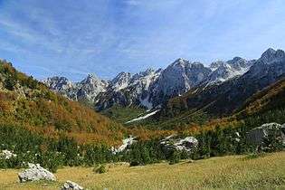
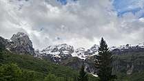
Albanian Alps
_sa_Karanfila_(2480).jpg)
_in_the_Albanian_Alps.jpg)
The composition of the great tectonic units reflects the history of the formation of the Albanian Alps. The Albanian Alps, also known as the Prokletije, are the southernmost part of the Dinaric Alps, forming part of the Alpine-Himalayan orogenic belt, that extends from the Atlantic Ocean to the Himalaya Mountains. This belt was formed during the Paleogene Period, as the Arabian, African, and Indian continental plates began to collide with the Eurasian plate. The Albanian Alps extend more than 64 kilometres (40 mi) from the Lake of Shkodër along the Albanian-Montenegrin border in the southwest up to Kosovo in the northeast. Albania encompasses the significant portion of the Alps. The total area is 2.240 square kilometres (0.865 sq mi). The mountain range stretches from the Dukagjin highlands north of the river Drin in the west through Theth and the Valbonë Valley, Tropojë region near the Albanian-Kosovan border in the east. The ice ages had relatively little direct geologic influence on the Albanian Alps. No permanent ice caps existed, and there is little evidence of extensive glaciation. However, the southernmost glaciers in Europe were recently discovered in the Albanian part of the range.[24]
The range include many of the important rivers of the southeastern part of the Western Balkans. Rivers in this range fall roughly into two main categories, those that flow into the Lim and those that enter the White Drin and meet the Black Drin downstream at the Drin confluence. However, Drin dominates, draining most of the ranges with its tributaries and when measured from the source of the White Drin to the mouth of the Drin near Lezhë. However, not all of the Drin flows near or parallel to the Alps. One Drin tributary is the Valbonë, which drains into the Adriatic sea, and its eastern tributary the Gashi River. There are about 20 small alpine lakes on the Alps, located on the Albanian-Kosovan border. Furhtermore, the highest peaks of the Albanian Alps are located in the Albanian territory. The range is host to two national parks; the Theth National Park covering an area of 26,300 square metres (283,000 sq ft) and the Valbonë Valley National Park 80,000 square metres (860,000 sq ft).
The Maja Jezercë is the highest peak of the Albanian Alps and the entire Dinaric Alps with an elevation of 2,694 metres (8,839 ft).[25] However, it is the 2nd highest peak of Albania. Other high summits within the Northern Mountain Range includes Maja Radohimës 2,570 metres (8,430 ft), Maja Kollatës 2,554 metres (8,379 ft), Maja Gjallica 2,489 metres (8,166 ft), Maja Bogiçaj 2,405 metres (7,890 ft), Maja Koritnik 2,393 metres (7,851 ft), Maja Shkëlzen 2,404 metres (7,887 ft) and Maja e Thatë 2,404 metres (7,887 ft).
Ceraunian Mountains
The Ceraunian is a coastal mountain range in southwestern Albania, stretching 100 kilometres (62 mi) from Orikum along the Albanian Riviera up to Sarandë. The relief is varied, with many mountain passes, gorges and landforms. The mountains are characterized by its Black pines, Bulgarian firs, Bosnian pines and ash trees. It is inhabited by many mammal species, including brown bears, grey wolves, lynxes, golden eagle and so on. The highest peak on the range is Maja e Çikës within the Llogara National Park, with an elevation of 2,045 metres (6,709 ft). It is the 24th highest mountain in the Republic of Albania. On the peak, there is a magnificent view of the Albanian coast, the northern Ionian Islands as well as the Italian coast of Apulia and including Otranto. The section has wide and long beaches, with a number of bays and headlands.
The Llogara Pass 1,027 metres (3,369 ft) divides the range into a western and an eastern range. The villages of Palasë, Dhërmi, Vuno, Himarë, Qeparo, Borsh, Pilur, Kudhës and Ilias are located on the Ceraunian range. The Llogara National Park covers an area of 10,100 square metres (109,000 sq ft) and
Korab Mountains

The Korab is a limestone mountain range located in Southeastern Europe near the tripoint of Albania, Macedonia and Kosovo, southwest of the Sharr Mountains. It is part of the inner Albanides in the line Dinarido-Albanido-Hellenides range mountains. The limestone rockies in the Korab is a Paleozoic period rock with numerous fossils.[26]
Located about 2,000 metres (6,600 ft) above sea level, this region is characterized by a limestone highland with deep river valleys. The valley of the Drin lies around 400 metres (1,300 ft) to the west, the mouth of the Radika at about 1,000 metres (3,300 ft). The Korab mountain is the highest peak on the range as well one of the highest in the Balkans, reaching an elevation of 2,764 metres (9,068 ft), being also one of only two summits in Europe which are the highest point for more than one country.[27] It is characterized by alpine landsapces with steep rocky peaks. Other high summits are Maja e Pikellimes 2,392 metres (7,848 ft), Gjallica Mountain 2,484 metres (8,150 ft), Mali i Gramës 2,345 metres (7,694 ft) and Dešat's Velivar 2,375 metres (7,792 ft).[28] Afterwards, the range falls away to the city of Debar and the Debar Lake.[29]
Almost 37 mammals can be found in the area, with a high diversity and density of bird species, including resident, migratory, breeding and wintering species.[30] The areas are dominated by Bosnian pines, European beech, Coppicing forest, and Alder forest.[31]
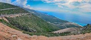
Karaburun Peninsula

The Karaburun Peninsula is situated in southwestern Albania, being the northern part of the Albanian Riviera at the eastern side of the Strait of Otranto, where the Adriatic sea meets the Ionian sea. Its area is 62 square kilometres (24 sq mi), having a length of 16 kilometres (9.9 mi), and a width of only 5 kilometres (3.1 mi).[32] The Mesokanali is the narrow channel, that separates the peninsula from the Sazan Island. Geologically, it is made up of carbonic limestone, dating back to the Mesozoic era, while in the northewestern it is composed of terrigenous sediment.[33] Furthermore, these formations have been continuously under the effect of Karst and are exploited as marble. The relief of the peninsula comprises a number of hills with a average altitude of about 800 metres (2,600 ft) above the sea level. The highest summits are Maja e Ilqes 733 metres (2,405 ft), Maja e Flamurit 826 metres (2,710 ft) and Maja Çadëri 839 metres (2,753 ft).[34]
The coastal landscape is characterized by a rough relief, that dips vertically into the Ionian sea, it features several solitary peaks, large canyons, bays, caves and gulfs such as the Gjipe Canyon, Gjiri i Arushës (Bear’s bay), Gjiri i Dafinës (Laurel bay), Raguza Bay, Grama bay and so on. The geological evolution has formed also capes such as Haxhi Aliu, Galloveci and Kepi i Gjuhëzës, and other of 20 caves along the entire coast.
Since 2010, the Karaburun Peninsula is part of the Karaburun-Sazan National Marine Park. The climate is mediterranean, having hot summers and generally warm to cool, dry winters. Due to its climatic, hydrological and geological conditions, the area is characterized by its unique biodiversity. Most of the territory consists of forests and is relatively well preserved, it include many types of trees, such as Mediterranean oak, Manna ash, Kermes oak and the Field maple.[35]
Hydrology


The territory of Albania covers about 65% of a total water area of 43,905 square kilometres (16,952 sq mi). Albania has around 247 natural lakes, most of karstic or glacial origin.[36] Albania's major lakes include the Lake of Shkodër, which is the largest lake in Southern Europe, the Lake of Ohrid, one of the most ancient lakes in the world and the oldest lake in Europe[37][38], the Lake of Prespa and the Lake of Butrint in southern Albania near the city of Sarandë. However, Albania is host to four lagoons. These include the Karavasta lagoon, that is among the largest in the Mediterranean sea on the Adriatic sea, the Patoku Lagoon, the Narta lagoon on the Ionian sea, the Lezhë lagoon extend on both sides of the Drin delta, and the Butrint lagoon located in the southern Ionian sea.[39]
The northern, central and southern mountain ranges divide Albania into two nearly equal drainage systems. Albania has a dense network of about 152 rivers and streams, forming at least 8 large rivers flowing from east to west, mainly discharging towards the Adriatic sea. The rivers of Albania are characterized by a high flow rate.[40] There are two catchment basins such as the Adriatic Sea and the Ionian Sea basins. The eight rivers are the Drin 285 kilometres (177 mi), Vjosë 192 kilometres (119 mi), Shkumbin 181 kilometres (112 mi), Mat 115 kilometres (71 mi), Erzen 108 kilometres (67 mi), Seman 85 kilometres (53 mi), Ishëm 74 kilometres (46 mi), and the Buna 74 kilometres (46 mi).

Nearly all of the precipitation that falls on Albania, drains into the rivers and reaches the coast on the west without even leaving the country. In the north, only one small stream escapes Albania. In the south, an even smaller rivulet drains into Greece. Due to the topographical divide is east of the border with the Republic of Macedonia. An extensive portion of the basin of the White Drin, basin is in the Dukagjin region, across the northeastern border with Kosovo. The Lake of Ohrid, Lake of Prespa and the Small Lake of Prespa on the southeast, as well as the streams that flow into them, drain into the Black Drin. The watershed divide in the south also dips nearly 75 km (47 mi) into Greece at one point. Several tributaries of the Vjosa River rise in that area.
The longest river located in the Albanian territory is the Drin, with a length of 285 kilometres (177 mi) and a catchment area of 5,957 km2 (2,300 sq mi). Fed by melting snows from the northern Albanian Alps and the eastern Korab mountains and by the more evenly distributed seasonal precipitation of that area, its flow does not have the extreme variations characteristic of nearly all other rivers in Albania. As it collects from the Adriatic portion of Kosovo's watersheds and the Lake of Prespa, Small Lake of Prespa drains to the Lake of Ohrid along an underground stream, its total basin encompasses about 15,540 km2 (6,000 sq mi). The Semani and Vjosë are the only other rivers that are longer than 160 km (99 mi) and having basins larger than 2,600 km2 (1,004 sq mi).
Adriatic sea
Albania's Adriatic sea mainland coast is 274 kilometres (170 mi) long, starting on the border with Montenegro south to the Bay of Vlorë, where the Ionian sea and the Albanian Riviera begins.[42] 74% is low-land coast (35% sandy beach and 39% by river mouth deposits or marshlands). The Adriatic basin is composed of pine forest and several lagoonss, including the Karavasta Lagoon and Patoku Lagoon. In addition, the Karavasta Lagoon is home to 6.4% of the Europe's population of the rare Dalmatian pelican, that is under protection.[43] The lagoon is considered as one the largest lagoons on the Mediterranean sea. The Adriatic's western shores are largely either alluvial or terraced, whereas the eastern shores are predominantly rocky, except for the southernmost part of the shore located in Albania that consists of sandy coves and rocky capes. The major Albanian port cities on the Adriatic sea are Durrës, Shëngjin and Vlorë. Albania has 10 islands on the Adriatics, with Sazan Island with a coastline of about 15 km (9.3 mi) and Kunë Island, being larger than 1 square kilometres. Sazan is strategically located between the Strait of Otranto and the entrance to the Bay of Vlorë; it is the country's westernmost point. The climate is not Mediterranean but rather subtropical on account of its warm winters and hot summers. The climate and vegetation resemble those of the south of Crete, Tunisia and even parts of Egypt. The flora is different from that of the rest of Albania in that it is subtropical.
In 2010, Albania established its first marine protection area, the Karaburun-Sazan National Marine Park at the Karaburun Peninsula. The Gjipe Canyon is the point, where the Adriatic meets the Ionian sea. It covers a total of 12,570 hectares (31,100 acres).[44] Two additional marine protection areas are planned in Albania, including the Cape of Rodon and Porto Palermo.[45] In addition, Albania is home to two Ramsar wetland reserves such as Karavasta Lagoon, and Butrint.[46]
Ionian sea

The Ionian sea mainland coast is 172 kilometres (107 mi) long, starting from the Gjipe Canyon in the Karaburun Peninsula, to the border with Greece.[47] This coastline represents the Albanian Riviera. The Ionian littoral is represented western edge of the Çika anticline belt in Ionian tectonic zone. 80% of the Ionian litoral is rocky high coast.[48] Mountains rise up to 2,045 metres (6,709 ft). The Ceraunian coastal mountain range extends nearly 100 kilometres (62 mi) along the Albanian Riviera in a northwesterly direction from the Albanian-Greek border to the Strait of Otranto. Its highest peak are Çika 2,012 metres (6,601 ft), the Llogara Pass 1,027 metres (3,369 ft) divides the mountains into a western and an eastern range.
The coastline continues down along the coast through the villages of Borsh, Dhermi, Himara, Qeparo, and Piqeras, and ends at Lukovë.[49] Sarandë is ahead with Vlorë, the largest city along the Albanian Ionian coastline. It is also home to 2 islands, with Ksamil being the largest with an area of 71,000 square metres (760,000 sq ft), followed by the rocky Tongo Island. There are 5 protected areas such as the Butrint National Park, Karaburun-Sazan National Marine Park, Llogara National Park, Blue Eye spring and Porto Palermo.

 Village of Dhërmi on the hill of the Ceraunians
 Gjiri i Skalomës in the Karaburun Peninsula
 Hills between the village of Kakomë and
 View of the Borsh village and its flora
Climate
Considering its relatively small area, Albania has variable and complex climate. It's diverse regions have different climates, with the weather system on the coasts contrasting with that prevailing in the interior. However, the weather in Albania varies from the north to the south. The warmest areas of Albania are at the Adriatic and Ionian coast, which are characterized by a Mediterranean climate (Csa, Csb and Cfa) as defined by the Köppen climate classification. The highlands have a Oceanic climate. Winters in Albania are characteristically mild and wet while summers are warm and dry. The northern areas of Albania such as the Albanian Alps, that are the southernmost part of the Dinaric Alps, have Subarctic climate with frequently very cold winters, and short, mild summers.
The lowlands of Albania have mild winters, averaging about 7 °C (45 °F). The summer temperatures average 32 °C (90 °F), however, humidity is low. In the southern lowlands specifically the areas on the Ionian sea, temperatures average about 5 °C (41 °F) in the winter and 30 °C (86 °F) during the summer.
Biodiversity
.jpg)
Although a small territory, Albania can be subdivided between a number of ecoregions, due to its climatic, hydrological, geological and topographical conditions, which makes the country one of the richest in Europe in terms of biodiversity; 30% of the entire flora species and 42% of fauna in Europe are found in Albania.[50] In terms of phytogeography, Albania is part of the Boreal Kingdom specifically, part of the Illyrian province of the Circumboreal Region and Mediterranean region within the Boreal kingdom. Albania is divided into three ecoregions including Illyrian deciduous forests, Dinaric mixed forests, Balkan mixed forests and Pindus mixed forests. Further, Biomes in Albania include Temperate broadleaf and mixed forest and Mediterranean forests, woodlands, and scrub, forming part of the Palearctic ecozone.
On the territory of Albania, there are 799 Albanian protected areas covering a surface of 4,600 square kilometres (460,000 hectares). These include 15 national parks, 5 protected landscape areas, 4 strict nature reserves, 23 managed nature reserves, 2 nature and science reserves, 4 protected resource areas and 750 monuments of nature.[51][52] The national parks covering a surface area of 210,668.48 hectares (2,106.6848 km2) or roughly 13.65% of the overall territory.[53] The nation host also 8 archaeological parks covering a surface area of 1,120 hectares (11.2 km2). The largest national park in Albania is the Fir of Hotova National Park, covering a surface area of 34,361 hectares (343.61 km2) and having the largest area of Bulgarian Fir in the Balkans.
See also
| Wikimedia Commons has media related to Geography of Albania. |
Notes
| a. | ^ Kosovo is the subject of a territorial dispute between the Republic of Kosovo and the Republic of Serbia. The Republic of Kosovo unilaterally declared independence on 17 February 2008, but Serbia continues to claim it as part of its own sovereign territory. The two governments began to normalise relations in 2013, as part of the Brussels Agreement. Kosovo has received formal recognition as an independent state from 111 out of 193 United Nations member states. |
References
- ↑ "Introduction" (PDF). dspace.epoka.edu.al.
Albania has 28.748 square kilometers area and the length of the borderline of the Republic of Albania is 1094 km, of which 657 km land border, 316 km of coastline, 48 km and 73 km through rivers dividing line through the lakes.
- ↑ "ALBANIA". cia.gov.
Southeastern Europe, bordering the Adriatic Sea and Ionian Sea, between Greece to the south and Montenegro and Kosovo to the north
- ↑ "Albania country profile". bbc.com. Europe. 19 June 2017.
Albania is a small, mountainous country in the Balkan peninsula, with a long Adriatic and Ionian coastline.
- ↑ R. Eftimi. "SOME CONSIDERATIONS ON SEAWATER-FRESHWATER RELATIONSHIP IN ALBANIAN COASTAL AREA" (PDF). ITA Consult.
- ↑ "Introduction" (PDF). dspace.epoka.edu.al. p. 252.
Although a small country, Albania has rich physical geography features. The variation of geomorphology, climate, biological diversity, rivers and lakes create favorable conditions. These features affected on human and their activities.
- ↑ "Biodiversity Albania". climatechangepost.com.
Some of the 30% of the European plant species, and 42% of the European mammals can be found in the country. Albania's variety of wetlands, lagoons and large lakes also provide critical winter habitat for migratory birds (1).
- ↑ "BIODIVERSITY IN ALBANIA REPORT ON NATIONAL SITUATION OF BIODIVERSITY IN ALBANIA" (PDF). macfungi.webs.com. p. 2.
Approximately 30% of all European floras occur in Albania.
- ↑ http://sea.unep-wcmc.org/wdbpa/country1.cfm?Country=ALB
- ↑ Përshkrimi i Rrjetit aktual të zonave të mbrojtura
- ↑ "IBAC 2012 vol.2" (PDF). dspace.epoka.edu.al. p. 253.
In the North-Western part of the country, there is the Shkoder Lake, which is the largest in the Balkan Peninsula.
- ↑ "Natural and Cultural Heritage of the Ohrid region". whc.unesco.org. pp. UNESCO.
Situated on the shores of Lake Ohrid, the town of Ohrid is one of the oldest human settlements in Europe; Lake Ohrid is a superlative natural phenomenon, providing refuge for numerous endemic and relict freshwater species of flora and fauna dating from the tertiary period. As a deep and ancient lake of tectonic origin, Lake Ohrid has existed continuously for approximately two to three million years.
- ↑ "Lake Ohrid; Invest in Macedonia – Agency for Foreign Investments of the Republic of Macedonia". InvestInMacedonia.com. Retrieved 3 June 2017.
- ↑ "Population of Albania" (PDF). instat.gov.al. p. 1.
The population of Albania on January 1st is 2,886,026 inhabitants, compared to the population of 2015 there is a decrease of 6,276 inhabitants. The sex ratio of this population is 102.6 males for 100 females. The median age of the population of Albania on January the 1st 2015 is 34.7 years.
- ↑ "Life expectancy at birth (years) 2000-2015". gamapserver.who.int.
- ↑ "Demographics of Albania 2016". countrymeters.info. 30 June 2017.
- ↑ Assessing the Comparative Advantage of Wheat Produced in Albania (Luce Agraja ed.). Cuvillier Verlag. p. 7. ISBN 9783867279994.
- ↑ "Geografie - Albanien". uni-koblenz.de (in German).
Angrenzende Länder - Griechenland 282 km
- ↑ The Green Belt of Europe: From Vision to Reality (Andrew Terry, Karin Ullrich, Uwe Riecken ed.). IUCN. p. 68. ISBN 9782831709451.
- ↑ "Geografie - Albanien". uni-koblenz.de (in German).
Angrenzende Länder - Griechenland 282 km
- ↑ Sustainable Development of Sea-Corridors and Coastal Waters: The TEN ECOPORT project in South East Europe (Chrysostomos Stylios, Tania Floqi, Jordan Marinski, Leonardo Damiani ed.). Springer. p. 85. ISBN 9783319113852.
- ↑ Buletini i i Universitetit Shteteror te Tiranes, 1964, p. 110
- ↑ "The National Parks Of Albania The fifteen national parks in Albania encompass an area of 210,668.48 hectares which accounts for about 3.65% of the overall territory of the country.". worldatlas.com.
Albania consists of different ecoregions that represent the natural geographical ecosystem, water, weather, and renewable resources. The territory of Albania can be divided into four ecoregions: Dinaric Alpine (mixed forests in the far north). Balcanic (mixed forest in the north-east). Pindus mountain (mixed forests covering the central and southeast mountains). Illyrian deciduous (forest covering the rest of the country).
- ↑ Osborn, Liz. "Sunniest Cities in Europe".
Many of Europe's sunniest cities rim the Mediterranean, or are located nearby.
- ↑ "FEASIBILITY STUDY ON ESTABLISHING A TRANSBOUNDARY PROTECTED AREA PROKLETIJE / BJESHKËT E NEMUNA MOUNTAINS" (PDf). condesan.org. p. 4.
The number of glacial ponds in this area is rare for the European mainland and can only be compared to the Alps.
- ↑ "FEASIBILITY STUDY ON ESTABLISHING A TRANSBOUNDARY PROTECTED AREA PROKLETIJE / BJESHKËT E NEMUNA MOUNTAINS" (PDF). condesan.org. p. 37.
The highest peaks of Prokletije / Bjeshkët e Nemuna mountains are Maja Jezercë/ Jezerski Vrh (2694 m) in Albania.
- ↑ "The King of the Mountains" (PDF). dmwcorg.tk. p. 24.
Korab is a very rugged mountain massif that consists mainly of shale and limestone of the Palaeozoic era with bloc structures.
- ↑ "The King of the Mountains" (PDF). dmwcorg.tk. p. 24.
At 2764 meters Korab peak is one of only two summits in Europe which are the highest point for more than one country.
- ↑ "Korab - Koritnik Natural Park Management Plan". researchgate.net. p. 25.
The main mountains in the area are Maja e Pikellimes (2,392m), Gjallica Mountain (2,484m), and Korab Mountain (2,751m), which is the highest mountain on Albanian territory.
- ↑ Perikli Qiriazi (2006). Gjeografia fizike e Shqipërisë. Tirana: Shtëpia botuese e librit universitar. p. 189. ISBN 99927-0-397-0.
- ↑ "Korab - Koritnik Natural Park Management Plan". researchgate.net.
At least, 37 species of mammals are found in the Korabi-Koritnik area. The diversity of habitats in the Mountains Natural Ecosystem “Korab - Koritnik Natural Park” give rise to a great diversity and density of bird species in the area, including resident, migratory, breeding and wintering species.
- ↑ "Korab - Koritnik Natural Park Management Plan". researchgate.net. p. 13.
Most of these areas are dominated by Bosnian pine (Pinus heldreichii) and European Beech (Fagus sylvatica).: - The sustainable zone includes Oak (Quercus) wood land, coppiced oak forest, beech (Fagus) forest and beech coppice, Alder (Alnus) forest along streams, rocky areas with little vegetation and extensive production of walnuts and chestnut.
- ↑ "Llogora-Rreza e Kanalit-Dukat -Orikum-TragjasRadhime-Karaburun Complex Site" (PDF). vinc.s.free.fr. p. 24.
The Karaburun Peninsula covers a surface of 62 km2; It is 16 km long and 3-5 km wide
- ↑ "Llogora-Rreza e Kanalit-Dukat -Orikum-TragjasRadhime-Karaburun Complex Site" (PDF). vinc.s.free.fr. p. 24.
From the geological point of view it is made up of carbonic limestone of Kretac era, while in the northewestern part of it, Bay of Shën Jani, it is composed of terigenic deposits.
- ↑ "Llogora-Rreza e Kanalit-Dukat -Orikum-TragjasRadhime-Karaburun Complex Site" (PDF). vinc.s.free.fr.
The relief comprises a number of hills. The average altitude from the sea levels 800 m with a number of peaks. The highest peaks are the so-called Maja e Ilqes (733 m), Maja e Flamurit (826 m) and Çadëri (839 m).
- ↑ "Llogora-Rreza e Kanalit-Dukat -Orikum-TragjasRadhime-Karaburun Complex Site" (PDF). vinc.s.free.fr. p. 43.
The most important trees in this type of forest are Quercus ilex, Fraxinus ornus, Quercus coccifera, Acer campestre, which form dense tree layer (cover 80 – 90 % in very well developed stands, height 8-10 m ).
- ↑ "The quality of Albanian natural waters and the human impact". researchgate.net. p. 134.
- ↑ "Natural and Cultural Heritage of the Ohrid region". whc.unesco.org. pp. UNESCO.
Situated on the shores of Lake Ohrid, the town of Ohrid is one of the oldest human settlements in Europe; Lake Ohrid is a superlative natural phenomenon, providing refuge for numerous endemic and relict freshwater species of flora and fauna dating from the tertiary period. As a deep and ancient lake of tectonic origin, Lake Ohrid has existed continuously for approximately two to three million years.
- ↑ "Lake Ohrid; Invest in Macedonia – Agency for Foreign Investments of the Republic of Macedonia". InvestInMacedonia.com. Retrieved 3 June 2017.
- ↑ "The quality of Albanian natural waters and the human impact". researchgate.net. p. 138.
Karavasta lagoon represents the largest lagoon inAlbania and is among the biggest of the Adriatic basin; - Lezha lagoons extend on both sides of the Drini delta,Ceka lagoon in the southern part of river delta, Merxhanilagoon and Kenalla pond on its northern side; - Narta lagoon (Vlora) is situated at the southern Adriaticcoast; it is 42 km2in size and has a depth of 0.3 to 1.0 m.: - Butrinti lagoon is 16.3 km2in size with a mean depth of14 m and a maximal depth of 21 m. It is situated in thesouthern part at the Ionian Sea.
- ↑ "nces See all › 7 FiguresShare Download full-text PDF The quality of Albanian natural waters and the human impact". researchgate.net. p. 137.
Albanian rivers are characterized by ahigh flow rate; the total annual mean flow is 1308 m3s1,which corresponds to an annual water volume of 41,250 km3.
- ↑ Fred Pearce. "Scientists demand halt to damming of Europe’s last wild river". newscientist.com. Retrieved 23 September 2016.
- ↑ Sustainable Development of Sea-Corridors and Coastal Waters: The TEN ECOPORT project in South East Europe (Chrysostomos Stylios, Tania Floqi, Jordan Marinski, Leonardo Damiani ed.). Springer. p. 85. ISBN 9783319113852.
- ↑ "ACTION PLAN FOR THE DALMATIAN PELICAN" (PDF). ec.europa.eu.
The Dalmatian Pelican has been protected since 1988 by the “Hunting Law”
- ↑ "Vendim për shpalljen "Park Kombëtar" të ekosistemit natyror detar pranë gadishullit të Karaburunit dhe ishullit të Sazanit" [Decision to declare as a "National Park" the maritime natural ecosystem of Karaburun Peninsula and Sazan Island] (in Albanian). shqiperia.com. Retrieved 31 January 2012. (in Albanian)
- ↑ "Protecting Albania's Marine and Coastal Biodiversity". al.undp.org.
Strategic Plan on Marine and Coastal Protected Areas assists a coordinated decision making for an ecosystem-based spatial management, ensuring sustainable development while conserving and managing natural biodiversity and resources. It is incorporated in the Strategic Document of the Biodiversity Protection and Action Plan recently approved by the Government of AlbaniaIn line with this, there are two new potential MPA under assessment namely Porto – Palermo and Rodoni Cape.
- ↑ "The Annotated Ramsar List: Albania". Ramsar Convention. Archived from the original on 25 May 2012. Retrieved 3 February 2012.
- ↑ Sustainable Development of Sea-Corridors and Coastal Waters: The TEN ECOPORT project in South East Europe (Chrysostomos Stylios, Tania Floqi, Jordan Marinski, Leonardo Damiani ed.). Springer. p. 85. ISBN 9783319113852.
- ↑ Sustainable Development of Sea-Corridors and Coastal Waters: The TEN ECOPORT project in South East Europe (Chrysostomos Stylios, Tania Floqi, Jordan Marinski, Leonardo Damiani ed.). Springer. p. 85. ISBN 9783319113852.
- ↑ Gloyer, Gillian (2008). The Bradt Travel Guide Albania. Bradt Publications UK. p. 199. ISBN 1-84162-246-X.
- ↑ "Biodiversity Albania". climatechangepost.com.
Some of the 30% of the European plant species, and 42% of the European mammals can be found in the country. Albania's variety of wetlands, lagoons and large lakes also provide critical winter habitat for migratory birds (1).
- ↑ "Biodiversity and Protected Areas-- Albania" (PDF). catsg.org.
- ↑ "Albania, Europe". protectedplanet.net.
- ↑ Përshkrimi i Rrjetit aktual të zonave të mbrojtura
External links
- Albinfo Interactive Topographic Map of Albania
- Albanian Address System Geoportal
- Ministry of the Environment of Albania
- Institute for Environmental Policy of Albania
- Ekolevizja Environmental Movement
- Albania Weather
- Further readings
- Dako, Alba; Mirela Lika, and Hysen Mankolli. "Monitoring Aspects of Air Quality in Urban Areas of Tirana and Durrës, Albania". Natura Montenegrina 7, no. 2 (2008): 549–557.
- Floqi, Tania; Daut Vezi and Ilirian Malollari. "Identification and Evaluation of Water Pollution from Albanian Tanneries", Desalination 213, no. 1-3 (2007): 56–64.
- Muller, Daniel; and Thomas Sikor. "Effects of Post-Socialist Reforms on Land Cover and Land Use in South-Eastern Albania". Applied Geography 26, no. 3-4 (2006):175–191.
