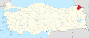
Ardahan Province
| Ardahan Province Ardahan ili | |
|---|---|
| Province of Turkey | |
 Location of Ardahan Province in Turkey | |
| Country | Turkey |
| Region | Northeast Anatolia |
| Subregion | Ağrı |
| Government | |
| • Electoral district | Ardahan |
| Area | |
| • Total | 5,661 km2 (2,186 sq mi) |
| Population (2010)[1] | |
| • Total | 98,335 |
| • Density | 17/km2 (45/sq mi) |
| Area code(s) | 0478 |
| Vehicle registration | 75 |
Ardahan Province (Turkish: Ardahan ili), is a province in the north-east of Turkey, at the very end of the country, where Turkey borders with Georgia and Armenia. The provincial capital is the city of Ardahan.
Geography
Ardahan province is located in the far north east of Turkey, where the eastern extremity of the high plateau of Eastern Anatolia converges with the Lesser Caucasus mountain range. It is consequently an area of very high altitude and severe winters. This is attractive open countryside which however spends many months of the year under snow. At this altitude temperatures on average reach −20 °C (−4 °F) and can drop below freezing all year round, including summer months.
The local economy depends on farming and raising livestock. Until 1993 Ardahan was a district of the province of Kars, becoming a province in its own right has meant more investment in infrastructure
There are two crossing points into the Samtskhe-Javakheti district of Georgia, one at Posof and the other (currently closed) at Çıldır. The Turkish military have a strong presence in this border district, another boost to the local economy.
Climate
The predominant climate in the Ardahan province is humid continental climate (Köppen climate classification Dfb) bordering on a subarctic climate (Dfc), with most large settlements in the province being located in lowest possible elevation areas, in attempt to avoid the year-round cold temperatures, thus staying just below the subarctic limit. Smaller locales, districts, villages and a significant portion of the landscape, exhibits a true subarctic climate (Dfc), being the second most widespread climate in the region.[2]
Population
Ardahan is an impoverished area that since the 1950s has seen a large number of its people migrate to other parts of Turkey or abroad. The population declined from 170,000 people in 1990 to 119,000 in 2000. The population is 105,454 as of 2010. Ethnic groups in the region include, Turks, Georgians and Azerbaijanis. In the period when the province was part of Russian Empire between 1878 and 1917, it was part of the militarily administered Kars Oblast, its population was even more diverse, with large numbers of Armenians, Caucasus Greeks, and Russians. They were removed in the Treaty of Kars due to their Christian religion.
History
In 680 BC Scythians came across the Caucasus from the north and captured this area from the Urartu Kings that ruled from their capital on the shores of Lake Van to the south. The Scythians were replaced by Persians and then in 330(?) BC Alexander the Great came through with his armies. Ethnic Georgians populated the area, and in between conquests, it was a province of a Georgian Kingdom after whose paritition in the 1490s the area passed to the atabegs of Samtskhe based in Akhaltsikhe until it was taken over by the Ottoman Empire in 1578.
In 1878, after the Russo-Turkish War (1877–1878), the region was incorporated into the Russian Empire, and until 1918 was known as Kars Oblast. Part of the Democratic Republic of Georgia from 1918 to 1921, Ardahan was reclaimed by Turkey under the Treaty of Kars in 1921.
The construction of the Baku–Tbilisi–Ceyhan pipeline gave the local economy a brief boost from 2000 onwards.
Districts
Ardahan province is divided into 6 districts (capital district in bold):
Cities and towns
- Ardahan City 17,171 inh.
- Göle City 6,231 inh.
- Hanak City 4,030 inh.
- Damal City 3,804 inh.
- Köprülü Town 2,126 inh.
- Posof City 1,810 inh.
- Çıldır City 1,502 inh.
Places of interest
- There are a number of medieval castles in the district including Ardahan Castle itself.
- Lake Çıldır
- Phantom of Atatürk in city of Damal
There is a unique natural incident, between mid of June and mid July during sunset, depending on angles of sun xrays; phantom of Atatürk is visible. It was first seen by a shepherd who was with his herd over the hill.
See also
Coordinates: 41°06′47″N 42°49′15″E / 41.11306°N 42.82083°E
References
- ↑ Turkish Statistical Institute, MS Excel document – Population of province/district centers and towns/villages and population growth rate by provinces
- ↑ "Climate:Ardahan". Climate-data.org. Retrieved 2016-06-09.
