Arang Kel

From Wikipedia, the free encyclopedia
| Arang Kel | |
|---|---|
| Village | |
|
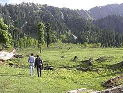
Heading towards glaciers from Arang Kel | |
| Country |
|
| Elevation | 2,554 m (8,379 ft) |
| Languages | |
| • Official |
Koshur
Hindko
Urdu |
| Time zone | PST +5:30 |
Arang Kel is a lush green village, hill station and tourist spot in Neelam valley, Azad Kashmir, Pakistan. It is located on the hill top above Kel at the altitude of 8,379 feet (2,554 m) feet.[1]

Accessibility
The village is accessible by a 2 kilometers (1.2 mi) trek from Kel. The location can also be accessed by a kilomter long chair left administrated by Pak Amry.To reach Kel people usually enter into the Neelam valley from Muzafarabad.Road are good private cars can approach easily till kel. Kel is located just 19 kilometers (12 mi) ahead from Sharda at the altitude of 6,879 feet (2,097 m).
Accommodation and guest houses
Beautiful guest houses can be easily found in the range of Rs1000-Rs6000 ($10-$20) per person. Food is not (comparatively) cheap, as locals have to use donkeys and horses to take food items from Kel to Arang Kel.
See also
References
- ↑ "Neelum Valley". AJK Tourism & Archaeology Department. Retrieved 28 July 2013.
| Wikimedia Commons has media related to Arang Kel. |
Coordinates: 34°48′23″N 74°20′46″E / 34.8063°N 74.3460°E