Anröchte
| Anröchte | ||
|---|---|---|
| ||
 Anröchte | ||
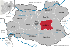
Location of Anröchte within Soest district 
 | ||
| Coordinates: 51°34′N 8°20′E / 51.567°N 8.333°ECoordinates: 51°34′N 8°20′E / 51.567°N 8.333°E | ||
| Country | Germany | |
| State | North Rhine-Westphalia | |
| Admin. region | Arnsberg | |
| District | Soest | |
| Government | ||
| • Mayor | Alfred Schmidt (Ind.) | |
| Area | ||
| • Total | 73.79 km2 (28.49 sq mi) | |
| Elevation | 197 m (646 ft) | |
| Population (2015-12-31)[1] | ||
| • Total | 10,557 | |
| • Density | 140/km2 (370/sq mi) | |
| Time zone | CET/CEST (UTC+1/+2) | |
| Postal codes | 59609 | |
| Dialling codes | 02947 02927 | |
| Vehicle registration | SO | |
| Website | www.anroechte.de | |
Anröchte (![]() Anröchte ) is a municipality in the district of Soest, in North Rhine-Westphalia, Germany.
Anröchte ) is a municipality in the district of Soest, in North Rhine-Westphalia, Germany.
Geography
It is situated approximately 13 km south of Lippstadt and 15 km east of Soest.
Neighbouring municipalities
Division of the town
After the local government reforms of 1975 Anröchte consists of 10 districts:
- Anröchte (7.087 inhabitants)
- Altengeseke (901 inhabitants)
- Altenmellrich (370 inhabitants)
- Berge (715 inhabitants)
- Effeln (7.520 inhabitants)
- Klieve (381 inhabitants)
- Mellrich (767 inhabitants)
- Robringhausen (153 inhabitants)
- Uelde (1.100 inhabitants)
- Waltringhausen (102 inhabitants)
Twin towns
References
- ↑ "Amtliche Bevölkerungszahlen". Landesbetrieb Information und Technik NRW (in German). 18 July 2016.
External links
- Official site (in German)
This article is issued from
Wikipedia.
The text is licensed under Creative Commons - Attribution - Sharealike.
Additional terms may apply for the media files.
