Bueng Khong Long District
| Bueng Khong Long บึงโขงหลง | |
|---|---|
| Amphoe | |
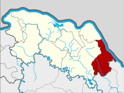 Amphoe location in Bueng Kan Province | |
| Coordinates: 17°58′0″N 104°2′42″E / 17.96667°N 104.04500°ECoordinates: 17°58′0″N 104°2′42″E / 17.96667°N 104.04500°E | |
| Country | Thailand |
| Province | Bueng Kan |
| Seat | Bueng Khong Long |
| Tambon | 4 |
| Muban | 51 |
| Amphoe established | 1986 |
| Area | |
| • Total | 398.152 km2 (153.727 sq mi) |
| Population (2015) | |
| • Total | 37,300 |
| • Density | 87.2/km2 (226/sq mi) |
| Time zone | ICT (UTC+7) |
| Postal code | 38220 |
| Geocode | 3806 |
Bueng Khong Long (Thai: บึงโขงหลง; IPA: [bɯ̄ŋ kʰǒːŋ lǒŋ]) is a district (amphoe) of Bueng Kan Province, northeastern Thailand.
Both this district and its Bueng Khong Long sub-district are named after a reservoir south of Bueng Khong Long town. The reservoir was created in the 1980s under a royal initiative by late King Bhumibol Adulyadej to provide irrigation for farmers as well as to enhance biodiversity. The lake's wetlands are an important stopover point for migrating birds, and also a spawning ground for fish. Fish are a key protein source for locals.[1]
History
The minor district was split off from Seka District on 7 January 1986.[2] It was upgraded to a full district on 4 November 1993.[3]
Geography
Neighboring districts are (from the south clockwise) Ban Phaeng and Na Thom of Nakhon Phanom Province, and Seka and Bung Khla of Bueng Kan Province. To the east across the Mekong River is the Laotian province Bolikhamxai.
Administration
Central administration
The Bueng Khong Long District is divided into four sub-districts (tambon), which are further subdivided into 57 administrative villages (muban).
| No. | Name | Thai | Villages | Pop.[4] |
|---|---|---|---|---|
| 1. | Bueng Khong Long | บึงโขงหลง | 17 | 10,805 |
| 2. | Pho Mak Khaeng | โพธิ์หมากแข้ง | 16 | 12,783 |
| 3. | Dong Bang | ดงบัง | 11 | 6,509 |
| 4. | Tha Dok Kham | ท่าดอกคำ | 13 | 7,203 |
Local administration
There are two sub-district municipalities (thesaban tambon) in the district:
- Bueng Khong Long (Thai: เทศบาลตำบลบึงโขงหลง) consisting of parts of sub-districts Bueng Khong Long and Pho Mak Khaeng.
- Bueng Ngam (Thai: เทศบาลตำบลบึงงาม) consisting of parts of sub-district Bueng Khong Long.
There are three sub-district administrative organizations (SAO) in the district:
- Pho Mak Khaeng (Thai: องค์การบริหารส่วนตำบลโพธิ์หมากแข้ง) consisting of parts of sub-district Pho Mak Khaeng.
- Dong Bang (Thai: องค์การบริหารส่วนตำบลดงบัง) consisting of the sub-district Dong Bang.
- Tha Dok Kham (Thai: องค์การบริหารส่วนตำบลท่าดอกคำ) consisting of the sub-district Tha Dok Kham.
References
- ↑ "Villagers work to protect the water and key wetlands in Bueng Khong Long reservoir". The Nation. 1 January 2017. Retrieved 1 January 2017.
- ↑ ประกาศกระทรวงมหาดไทย เรื่อง แบ่งเขตท้องที่อำเภอเซกา จังหวัดหนองคายตั้งเป็นกิ่งอำเภอบึงโขงหลง (PDF). Royal Gazette (in Thai). 103 (9 ง): 159. January 21, 1986.
- ↑ พระราชกฤษฎีกาตั้งอำเภอลำทับ อำเภอร่องคำ อำเภอเวียงแหง อำเภอนาโยง อำเภอแก้งสนามนาง อำเภอโนนแดง อำเภอบ้านหลวง อำเภอกะพ้อ อำเภอศรีบรรพต อำเภอแก่งกระจาน อำเภอหนองสูง อำเภอสบเมย อำเภอเมยวดี อำเภอโคกเจริญ อำเภอทุ่งหัวช้าง อำเภอผาขาว อำเภอวังหิน อำเภอดอนพุด อำเภอบึงโขงหลง และอำเภอห้วยคต พ.ศ. ๒๕๓๖ (PDF). Royal Gazette (in Thai). 110 (179 ก special): 1–3. November 3, 1993.
- ↑ "Population statistics 2015" (in Thai). Department of Provincial Administration. Retrieved 2016-03-22.