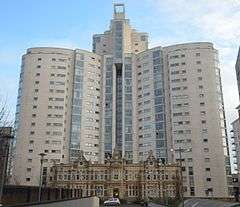
Altolusso
| Altolusso | |
|---|---|
 | |
| General information | |
| Type | Residential |
| Location | Cardiff, Wales |
| Address |
Bute Terrace, Cardiff city centre |
| Current tenants | Consort Property Management |
| Construction started | 2003 |
| Completed | 2005 |
| Cost | £40,000,000 ca. |
| Client | Redrow Homes |
| Owner | Freehold Managers |
| Height | 72 m (236 ft) |
| Technical details | |
| Floor count | 23 |
| Floor area | 19 697 m² (212,020 sq ft) |
| Lifts/elevators | 4 |
| Design and construction | |
| Architect | Holder Mathias Architects |
| Structural engineer | Ove Arup & Partners |
| Services engineer | McCann & Partners |
| Main contractor | Laing O'Rourke |
Altolusso (meaning "high luxury" in Italian) is a residential skyscraper in Cardiff, Wales. The building is 72 metres (232 ft) high and has 23 floors. The tower was the tallest residential building in Wales upon its completion in 2005, and remains one of the tallest buildings in Cardiff and in Wales.
The Y-shaped building contains 292 luxury one to three-bedroom apartments with views across the city. A three-storey car park allocated to the property. Altolusso is located close to The Hayes area of Cardiff city centre, near Cardiff International Arena and Cardiff Queen Street railway station.[1]
History
Historically, the site had been used for the production and storage of coal gas since 1837; when the Cardiff Gas Light and Coke Co established their facilities in Bute Terrace (formerly known as Whitmore Lane). The majority of the buildings remaining on site that were demolished in order for the scheme to proceed dated from the 1890s with some minor additions and modifications during the 1960s and 1990s.>
Architecture

Situated on the site of the former New College, the property retains the Victorian façade of the college for the first two floors.[2] The façade is not listed, but was retained at the request of Cardiff Council during the planning application. It had fallen into a poor state of repair by 2003, and modifications had been made over the years (such as a driveway leading through to the rear buildings). Extensive renovation and reconstruction of the façade was carried out using stone blocks from some of the rear buildings that were demolished. The façade forms part of the three-storey main foyer with a glass atrium roof.[3] The design of the building forms a three-leaf clover with three sweeping curvaceous wings emerging from a central service and access core.
The design intended not just to enhance the appeal of the development, but it was necessary to retain a high level of flatness and smoothness through the selection and application of the building's acrylic-based render to provide the building with durability and resilience against harsh weather conditions.[4]
Location
The building is bounded to the north by Bute Terrace, which forms part of the Cardiff inner distributor box, to the south by the main South Wales Main Line, to the east by Harlech Court with a car park and four-storey office building on a first floor podium and to the west by Meridian Gate, formerly a five-storey office building occupied by Axa Insurance. Its 3-4m high Victorian masonry and brick retaining wall defines the southern boundary of the site while the dock feeder, an artificial water course, passes the south eastern corner.
Use in media
Altolusso has been used during filming for the science fiction TV series Torchwood, which is filmed and produced in Cardiff. Filming took place on 8 June 2006, and shows the main character, Jack Harkness, standing on top of the building overlooking Cardiff.[5]
See also
References
- ↑ Archived 2 May 2007 at the Wayback Machine.
- ↑ "Portfolio Residential Altolusso Apartments". Archived from the original on 30 January 2009. Retrieved 7 April 2010.
- ↑ https://web.archive.org/web/20090107040101/http://www.holdermathias.com/residential/n/1/i/128. Archived from the original on 7 January 2009. Retrieved 7 April 2010. Missing or empty
|title=(help) - ↑ Archived 18 April 2010 at the Wayback Machine.
- ↑ "Altolusso – The Locations Guide to Doctor Who, Torchwood and The Sarah Jane Adventures". Doctorwholocations.net. Retrieved 7 March 2015.
External links
 Media related to Altolusso at Wikimedia Commons
- Images of Altolusso at skyscrapernews.com
- Laing O'Rourke Project Profile of Altolusso
Coordinates: 51°28′39″N 3°10′21″W / 51.47746°N 3.17254°W
