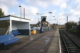
Althorne railway station
| Althorne | |
|---|---|
 | |
| Location | |
| Place | Althorne |
| Local authority | Maldon |
| Grid reference | TQ905979 |
| Operations | |
| Station code | ALN |
| Managed by | Abellio Greater Anglia |
| Number of platforms | 1 |
| DfT category | F2 |
|
Live arrivals/departures, station information and onward connections from National Rail Enquiries | |
| Annual rail passenger usage* | |
| 2011/12 |
|
| 2012/13 |
|
| 2013/14 |
|
| 2014/15 |
|
| 2015/16 |
|
| History | |
| Original company | Great Eastern Railway |
| Post-grouping | London and North Eastern Railway |
| 1 July 1889 | Opened |
| National Rail – UK railway stations | |
| * Annual estimated passenger usage based on sales of tickets in stated financial year(s) which end or originate at Althorne from Office of Rail and Road statistics. Methodology may vary year on year. | |
|
| |
Althorne railway station is on the Crouch Valley Line in the East of England, serving the village of Althorne, Essex. It is 40 miles 27 chains (64.9 km) down the line from London Liverpool Street and is situated between North Fambridge to the west and Burnham-on-Crouch to the east. Its three-letter station code is ALN.
The line and station were opened by the Great Eastern Railway in 1889. They passed to the London and North Eastern Railway following the Grouping of 1923, and then to the Eastern Region of British Railways upon nationalisation in 1948. When sectorisation was introduced, Althorne was served by Network SouthEast until the privatisation of British Railways.
Today the station is managed by Abellio Greater Anglia, which also operates all trains serving it. The typical off-peak service is of one westbound train every 40 minutes to Wickford and one eastbound train every 40 minutes to Southminster, with additional services at peak times. Some peak services continue to or from Shenfield and/or London Liverpool Street via the Great Eastern Main Line.
References
- Butt, R. V. J. (1995). The Directory of Railway Stations: details every public and private passenger station, halt, platform and stopping place, past and present (1st ed.). Sparkford: Patrick Stephens Ltd. ISBN 978-1-85260-508-7. OCLC 60251199.
- Jowett, Alan (2000). Jowett's Nationalised Railway Atlas (1st ed.). Penryn, Cornwall: Atlantic Transport Publishers. ISBN 978-0-906899-99-1. OCLC 228266687.
External links
| Wikimedia Commons has media related to Althorne railway station. |
- Train times and station information for Althorne railway station from National Rail
- Station on navigable O.S. map
- History of the Crouch Valley Line
- Local information about Crouch Valley Line
| Preceding station | |
Following station | ||
|---|---|---|---|---|
| North Fambridge | Greater Anglia Crouch Valley Line |
Burnham-on-Crouch | ||
Coordinates: 51°38′53″N 0°45′07″E / 51.648°N 0.752°E