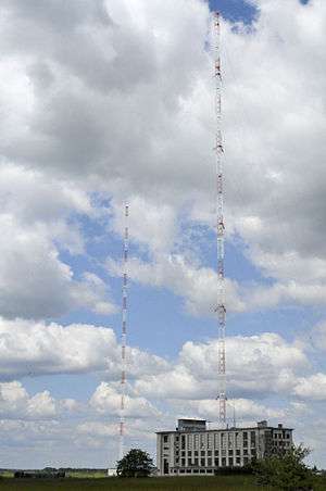
Allouis longwave transmitter
The Allouis longwave transmitter has been France's central longwave broadcast transmitter since 1939. It is located near the village of Allouis.

It broadcast the France Inter public radio station from October 1952[1] until 31st December 2016. Since 2017, it broadcasts only the TDF time signal.
The first transmitter, built in 1939 during the Phoney War, used an aerial with four masts and a transmitter rated at 500 kilowatts.[1] It was destroyed in 1944 during the scorched earth retreat by German forces.
On 19 October 1952 a new 250 kW transmitter came into service. This used a special cage aerial, mounted on a 308-metre high earthed mast. In 1957 the transmission power was increased to 600 kW, in 1974 to 1000 kW, and in 1981 to 2000 kW. Transmission power is reduced to 1000 kW during the hours of darkness.
In 1974 the aerial was renewed. The cage aerials were removed and the mast height was increased to 350 m. A second mast of the same height was constructed at the same time.
In 1977, the current phase modulated time signal was added to the transmissions. The broadcast frequency, formerly 164 kHz, was changed to 163.840 kHz (the 5th harmonic of the common 32768 Hz timekeeping frequency) to be a more convenient frequency standard.[2]
In 1980, the first atomic clock was installed to regulate the carrier frequency.[2]
On 1 February 1986, the frequency was changed to its current value of 162 kHz (still an accurately controlled frequency standard) to bring it to a multiple of 9 kHz in accordance with the Geneva Frequency Plan of 1975.
The radio channel France Inter announced during 2016 that the channel would discontinue transmitting on the 162 kHz frequency on 1 January 2017, seeking cost savings of approximately 6 million Euros per year. The transmission of the TDF time signal will be continued after this date, as this time signal is critical for over 200,000 devices, which are deployed within French enterprises and state entities, like the French railways SNCF, the electricity distributor ENEDIS, airports, hospitals, municipalities, et cetera.[3]
References
- 1 2 (in French)Chronologie des radios françaises en ondes longues 1921–2000 ("Chronology of french long-wave transmitters 1921–2000")
- 1 2 (in French)Les ré-orientations
- ↑ (in French)Le signal horaire restera sur le 162 kHz de France Inter
External links
- France Inter Radio Masts at Structurae
- (in French) http://perso.wanadoo.fr/tvignaud/am/allouis/fr-allouis.htm
- http://www.skyscraperpage.com/diagrams/?b44247
- http://skyscraperpage.com/diagrams/?b58020
Coordinates: 47°10′10.5″N 2°12′16.5″E / 47.169583°N 2.204583°E