Alberta Highway 52
| ||||
|---|---|---|---|---|
|
Highway 52 highlighted in red | ||||
| Route information | ||||
| Length: | 24.4 km[1] (15.2 mi) | |||
| Major junctions | ||||
| West end: |
| |||
| East end: |
| |||
| Location | ||||
| Specialized and rural municipalities: | Cardston County, Warner No. 5 County | |||
| Towns: | Raymond | |||
| Highway system | ||||
|
Provincial highways in Alberta
| ||||

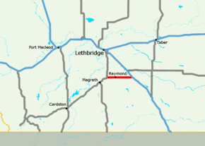
Alberta Provincial Highway No. 52, commonly referred to as Highway 52, is an east–west highway in southern Alberta, Canada, south of Lethbridge that connets Highway 4 to Highway 5 via Raymond.[1][2][3]
Major intersections
From west to east:
| Rural/specialized municipality | Location | km | mi | Destinations | Notes |
|---|---|---|---|---|---|
| Cardston County | Welling | 0 | 0.0 | 49°27′53.27″N 112°47′08.19″W / 49.4647972°N 112.7856083°W | |
| County of Warner No. 5 | | 6 | 3.7 | 49°27′52.76″N 112°42′19.21″W / 49.4646556°N 112.7053361°W | |
| Raymond | 9 | 5.6 | 49°27′54.82″N 112°39′44.19″W / 49.4652278°N 112.6622750°W | ||
| | 20 | 12 | 49°27′54.1″N 112°30′59.8″W / 49.465028°N 112.516611°W | ||
| | 25 | 16 | 49°27′49.94″N 112°29′03.26″W / 49.4638722°N 112.4842389°W | ||
| 1.000 mi = 1.609 km; 1.000 km = 0.621 mi | |||||
References
- 1 2 "2015 Provincial Highway 1-216 Progress Chart" (PDF). Alberta Transportation. March 2015. Archived (PDF) from the original on April 10, 2016. Retrieved October 31, 2016.
- ↑ Provincial Highways Designation Order, Alberta Transportation, p. 8
- ↑ Google (October 31, 2016). "Highway 52 in southern Alberta" (Map). Google Maps. Google. Retrieved October 31, 2016.
This article is issued from
Wikipedia.
The text is licensed under Creative Commons - Attribution - Sharealike.
Additional terms may apply for the media files.