Al Jemailiya
| Al Jemailiya لجميلية | |
|---|---|
| Town | |
|
Neighborhood in Al Jumaliyah | |
 Al Jemailiya | |
| Coordinates: 25°37′15″N 51°4′55″E / 25.62083°N 51.08194°ECoordinates: 25°37′15″N 51°4′55″E / 25.62083°N 51.08194°E | |
| Country | Qatar |
| Municipality | Al-Shahaniya |
| Area | |
| • Total | 623.3 km2 (240.7 sq mi) |
| Population (2015) | |
| • Total | 1,685 |
| • Density | 2.7/km2 (7.0/sq mi) |
%2C_village_centre.JPG)
%2C_park.JPG)
Al Jemailiya (Arabic: لجميلية) is a town in Qatar, located in the municipality of Al-Shahaniya.[1] It used to be the seat of Al Jemailiya Municipality before it was incorporated into Al Rayyan Municipality.[2] In 2014, the town was incorporated into the newly-created Al-Shahaniya Municipality.[3]
Etymology
Alternative spellings of Al Jemailiya's name are Al Jumaliyah, Al Gummayalah, Al Gummaylah and Al Jumaylīyah.[4]
The name derives from the Arabic word 'jamila', which means 'beauty'. It was so named because of its relative abundance of vegetation.[5]
History
Al Jemailiya was incorporated in Al-Shahaniya Municipality after the municipality was formed from parts of Al Rayyan Municipality in 2014.[3]
Al Jemailiya Municipality
In the 2004 census, when Al Jemailiya was a municipality, it was recorded as having administered Al Utouriya, Al Jemailiya (city), Umm Bab, Al Nasraniya, and Dukhan.[2]
When it was a municipality, it bordered the following municipalities:
- Al Ghuwariyah - north
- Al Khawr - northeast
- Umm Salal - east
- Ar Rayyan - southeast
- Jariyan al Batnah - south
In 2004, Al Jemailiya Municipality was merged with Al Rayyan Municipality.[4]
Municipality demographics
The following table shows the population of Al Jumaliyah Municipality.
| March 2004 | March 1997 | March 1986 |
|---|---|---|
| 10,303[2] | 9,836[6] | 7,217[7] |
In 2004 census, out of a municipal population of 10,303, the number of Muslims amounted to 6,782, Christians amounted to 965, and the remaining 2,566 inhabitants identified as following other religions.[8]
The following table shows the registered live births by nationality and sex for this municipality.[9] Place of births is based on home municipality of mother at birth.
| Year | Qatari male | Qatari female | Total Qatari | Non Qatari male | Non Qatari memale | Total non-Qatari | Total male | Total female | Grand total |
|---|---|---|---|---|---|---|---|---|---|
| 2001 | | | | | | | | | |
| 2002 | | | | | | | | | |
| 2003 | | | | | | | | | |
| 2004 | | | | | | | | | |
| 2005 | | | | | | | | | |
| 2006 | | | | | | | | | |
| 2007 | | | | | | | | | |
Geography
%2C_road.JPG)
%2C_closed_shops.JPG)
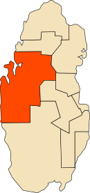
Al Jemailiya is situated in north-west Qatar. The villages of Lijmailiyah Al Shahwan and Al Qaaiyah are nearby.[10]
Demographics
As of the 2010 census, the town comprised 429 housing units[11] and 190 establishments.[12] There were 1,706 people living in the town, of which 60% were male and 40% were female. Out of the 1,706 inhabitants, 71% were 20 years of age or older and 29% were under the age of 20. The literacy rate stood at 91.5%.[13]
Employed persons made up 59% of the total population. Females accounted for 27% of the working population, while males accounted for 73% of the working population.[13]
| Year | Population |
|---|---|
| 1986[7] | 1,636 |
| 1997[6] | 1,303 |
| 2004[2] | 1,367 |
| 2010[14] | 1,706 |
| 2015[1] | 1,685 |
Visitor attractions
Mosques
%2C_mosque.JPG)
There are a number of mosques dating to the mid-20th century in the town. As a result of mass migration to the capital Doha over the years, most mosques were deserted.[15]
Bin Duham Mosque, erected in 1942, is one of the few dilapidated mosques in Al Jemailiyah. It has two entrances on the north and south side, respectively. The minaret, situated in the north-east section, lies on a thin base and is barrel-shaped. An outdoor prayer area is accessible through four pathways in the courtyard, while the prayer hall has three entrances leading from the outdoor area. The roof covering the prayer areas was constructed using plaited reed mats overlain with a mixture of mud and straw.[15]
Another old mosque in the village is Al Suwaheet Mosque, which was constructed in 1940. It has two entrances in the east and south, respectively. Its minaret extends 7.3 high and is separated into three segments of nearly equal size. The outdoor prayer area can be accessed through five rectangular pathways in the courtyard. There is also an indoor prayer hall.[16]
The oldest and smallest mosque is Al Amiri Mosque. Opened in 1939, it continued to remain in operation after the abandonment of the other mosques. It has a southern and northern entrance. The minaret is small and has a narrow base with no ornamental markings. There are outer and inner prayer areas. The mosque has undergone a number of renovations in its history, resulting in its roof being overlain with corrugated metal and concrete block pathways being created for the open prayer area.[17]
Education
The follows schools are located in Al Jemailiya:
| Name of School | Curriculum | Grade | Genders | Official Website | Ref |
|---|---|---|---|---|---|
| Al Jumailiya Girls Schools | Independent | Primary – Secondary | Female-only | N/A | [18] |
| Al Jumailiya Boys Schools | Independent | Primary – Secondary | Male-only | N/A | [18] |
References
- 1 2 "2015 Population census" (PDF). Ministry of Development Planning and Statistics. April 2015. Retrieved 8 August 2017.
- 1 2 3 4 "2004 population census". Qatar Statistics Authority. Retrieved 1 July 2015.
- 1 2 Hisham Yassin (16 January 2014). "بلدية الشحانية تضم %35 من مساحة الريان الحالية" (in Arabic). Al Arab. Retrieved 7 August 2017.
- 1 2 "Municipalities of Qatar". Statoids. Retrieved 11 August 2017.
- ↑ "GIS Portal". Ministry of Municipality and Environment. Retrieved 11 August 2017.
- 1 2 "1997 population census" (PDF). Qatar Statistics Authority. Archived from the original (PDF) on 29 May 2015. Retrieved 2 July 2015.
- 1 2 "1986 population census" (PDF). Qatar Statistics Authority. Archived from the original (PDF) on 3 July 2015. Retrieved 2 July 2015.
- ↑ "Population By Religion, Gender And Municipality March 2004". Municipality of Development Planning and Statistics. March 2004. Retrieved 11 August 2017.
- ↑ "Home page". Ministry of Development Planning and Statistics. Retrieved 11 August 2017.
- ↑ "Qatar Socio-Economic Atlas". Ministry of Development Planning and Statistics. Retrieved 8 August 2017.
- ↑ "Housing units, by type of unit and zone (April 2010)" (PDF). Qatar Statistics Authority. Retrieved 7 August 2015.
- ↑ "Establishments by status of establishment and zone (April 2010)" (PDF). Qatar Statistics Authority. Retrieved 7 August 2015.
- 1 2 "Geo Statistics Application". Ministry of Development Planning and Statistics. Retrieved 7 August 2015.
- ↑ "2010 population census" (PDF). Qatar Statistics Authority. Retrieved 29 June 2015.
- 1 2 Jaidah, Ibrahim; Bourennane, Malika (2010). The History of Qatari Architecture 1800-1950. Skira. p. 252. ISBN 978-8861307933.
- ↑ Jaidah, Ibrahim; Bourennane, Malika (2010). The History of Qatari Architecture 1800-1950. Skira. p. 256. ISBN 978-8861307933.
- ↑ Jaidah, Ibrahim; Bourennane, Malika (2010). The History of Qatari Architecture 1800-1950. Skira. p. 262. ISBN 978-8861307933.
- 1 2 "Qatari Schools". Supreme Education Council. Retrieved 18 July 2015.
Census designated areas
| |
Unincorporated and abandoned areas
|