Akabira, Hokkaido
| Akabira 赤平市 | |||
|---|---|---|---|
| City | |||
| |||
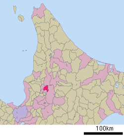 Location of Akabira in Hokkaido (Sorachi Subprefecture) | |||
 Akabira Location in Japan | |||
| Coordinates: 43°33′N 142°3′E / 43.550°N 142.050°ECoordinates: 43°33′N 142°3′E / 43.550°N 142.050°E | |||
| Country | Japan | ||
| Region | Hokkaido | ||
| Prefecture | Hokkaido (Sorachi Subprefecture) | ||
| Government | |||
| • Mayor | Yoshitaka Kikushima | ||
| Area | |||
| • Total | 129.88 km2 (50.15 sq mi) | ||
| Population (April 30, 2017) | |||
| • Total | 10,686 | ||
| • Density | 82/km2 (210/sq mi) | ||
| Symbols | |||
| • Tree | Maple | ||
| • Flower | Lily | ||
| • Bird | Varied tit | ||
| Time zone | Japan Standard Time (UTC+9) | ||
| City hall address |
4-1 Izumimachi, Akabira-shi, Hokkaidō 079-1192 | ||
| Website |
www | ||


Akabira (赤平市 Akabira-shi) is a city located in central Sorachi Subprefecture, Hokkaido, Japan. The name is Ainu for "mountain ridge".
As of April 30, 2017, the city has an estimated population of 10,686, and the density of 82 persons per km2.[1] The total area is 129.88 km2. The city was once a prosperous coal-mining city, its population reaching 59,430 in 1960. The population has been gradually declining.
History
- 1891 - Settlement begins.
- 1918 - Moshiri Coal Mine opens.
- 1922 - Second-class municipality Akabira Village split off of first-class municipality Utashinai.
- 1929 - Akabira becomes a First-Class municipality.
- 1937 - Shōwa Denkō Toyosato Mine opened.
- 1938 - Sumitomo Coal Mine, Hokkaido Coal Mine Railroad and Akama Coal Mine opened.
- 1943 - Akabira Village becomes Akabira Town.
- July 1, 1954 - Akabira Town becomes Akabira City.
- 1967 - Shōwa Denkō Toyosato Mine closesd.
- 1969 - Moshiri Coal Mine closed.
- 1973 - Akama Coal Mine closed.
- 1994 - Sumitomo Coal Mine closed.
- 2003 - Mid-Sorachi Merger Committee established.
- 2007 - A major elementary school in Akabira closed down. It once had about 5000 students but has dropped rapidly after the closure of the coal mines.
Transportation
Nemuro Main Line: Akabira - Moshiri - Hiragishi
Friendship cities
 Kaga, Ishikawa, Japan (since 1995)[2]
 Samcheok, Gangwon, South Korea (since 1997)
 Miluo City, Hunan, China (since 1999)
References
- ↑ "Official website of Akabira City" (in Japanese). Japan: Akabira City. Retrieved 16 May 2017.
- ↑ Friendship cities of Akabira
External links
| Wikimedia Commons has media related to Akabira, Hokkaidō. |
- Official website (in Japanese)
This article is issued from
Wikipedia.
The text is licensed under Creative Commons - Attribution - Sharealike.
Additional terms may apply for the media files.