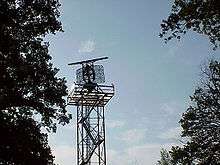
Airport surveillance radar

An airport surveillance radar (ASR) is a radar system used at airports to detect and display the presence and position of aircraft in the terminal area, the airspace around airports. It is the main air traffic control system for the airspace around airports. At large airports it typically controls traffic within a radius of 60 miles (96 km) of the airport. The sophisticated systems at large airports consist of two different radar systems, the primary and secondary surveillance radar.[1] The primary radar typically consists of a large rotating parabolic antenna dish that sweeps a vertical fan-shaped beam of microwaves around the airspace surrounding the airport. It detects the position and range of aircraft by microwaves reflected back to the antenna from the aircraft's surface. In the US the primary radar operates at a frequency of 2.7 - 2.9 GHz in the S band with a peak radiated power of 25 kW and an average power of 2.1 kW. The secondary surveillance radar consists of a second rotating antenna, often mounted on the primary antenna, which interrogates the transponders of aircraft, which transmits a radio signal back containing the aircraft's identification, barometric altitude, and an emergency status code, which is displayed on the radar screen next to the return from the primary radar.[1] It operates at a frequency of 1.03 - 1.09 GHz in the L band with peak power of 160 - 1500 W.
The positions of the aircraft are displayed on a screen; at large airports on multiple screens in an operations room at the airport called in the US the Terminal Radar Approach Control (TRACON), monitored by air traffic controllers who direct the traffic by communicating with the aircraft pilots by radio. They are responsible for maintaining a safe and orderly flow of traffic and adequate aircraft separation to prevent midair collisions.

Digital Airport Surveillance Radar (DASR)
The Digital Airport Surveillance Radar (DASR) is a new terminal air traffic control radar system that replaces current analog systems with new digital technology. The United States Air Force Electronics Systems Center, the US Federal Aviation Administration, US Army and the US Navy are in the process of procuring DASR systems to upgrade existing radar facilities for US Department of Defense (DoD) and civilian airfields. The DASR system detects aircraft position and weather conditions in the vicinity of civilian and military airfields. The civilian nomenclature for this radar is ASR-11. The ASR-11 will replace existing ASR-7 and ASR-8. The ASR-9 model is still in use and will continue to provide coverage until at least 2025. The military nomenclature for the radar is AN/GPN-30. The older radars, some up to 20 years old, are being replaced to improve reliability, provide additional weather data, reduce maintenance cost, improve performance, and provide digital data to new digital automation systems for presentation on air traffic control displays.[2] The Iraqi Air Force has received the DASR system.[3]

Display systems
ASR data is displayed on Automated Radar Terminal System (ARTS), Common Automated Radar Terminal System (CARTS), and Standard Terminal Automation Replacement System (STARS) display consoles in control towers and Terminal Radar Approach Control (TRACON) rooms, usually located at airports. CARTS will be replaced with STARS at all TRACONs during TAMR Phase 3 - Segment 1 as announced by the Federal Aviation Administration (FAA) in the Spring of 2011. All remaining ARTS (IIE) sites will be replaced with STARS during TAMR Phase 3 Segment 2 as announced by the FAA in the Spring of 2013.
The Standard Terminal Automation Replacement System (STARS) is a joint Federal Aviation Administration (FAA) and Department of Defense (DoD) program to replace Automated Radar Terminal Systems (ARTS) and other capacity-constrained, older technology systems at 172 FAA and up to 199 DoD terminal radar approach control facilities and associated towers.
STARS will be used by controllers, at facilities who already have it installed, to provide air traffic control (ATC) services to aircraft in terminal areas. Typical terminal area ATC services are defined as the area around airports where departing and arriving traffic are served. Functions include aircraft separation, weather advisories, and lower level control of air traffic. The system is designed to accommodate air traffic growth and the introduction of new automation functions which will improve the safety and efficiency of the US National Airspace System (NAS) as the legacy systems are replaced.[4]
Airport Surveillance Radar is beginning to be supplemented by ADS-B Automatic dependent surveillance-broadcast in the US and other parts of the world. As of Spring 2011, ADS-B is currently operational and in use at the Philadelphia, PA TRACON and Louisville, KY TRACON. ADS-B is a GPS based technology that allows aircraft to transmit their GPS determined position to display systems as often as once per second, as opposed to once every 4 seconds for a short range radar, or once every 13 seconds for a slower rotating long range radar. The FAA is mandating that ADS-B be fully operational and available to the NAS by the year 2020. This will make possible the decommissioning of older radars in order to increase safety and cut costs. As of 2011, there is no definitive list of radars that will be decommissioned as a result of ADS-B implementation.
See also
- Acronyms and abbreviations in avionics
- Air traffic control radar beacon system
- Air traffic control#Radar coverage
References
- 1 2 "Airport Surveillance Radar". Technology. US Federal Aviation Administration (FAA) website. 2014. Retrieved April 23, 2017.
- ↑ FAA ASR-11 Website
- ↑ Advanced Radar Improves Iraqi Air Surveillance American Forces Press Service (Oct. 30, 2009).
- ↑ FAA STARS website