British Columbia Highway 9
| ||||
|---|---|---|---|---|
| Agassiz-Rosedale Highway, Harrison Hot Springs Road, Haig Highway | ||||
|
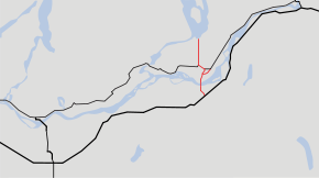
Highway 9 highlighted in red. | ||||
| Route information | ||||
| Length: | 15.6 km[1] (9.7 mi) | |||
| Existed: | 1953 – present | |||
| Major junctions | ||||
| South end: |
| |||
|
| ||||
| North end: | Harrison Hot Springs | |||
| Highway system | ||||
|
British Columbia provincial highways
| ||||

Highway 9, the Agassiz-Rosedale Highway, is a north-south route in the eastern part of the Fraser Valley. It acts as the last connection between the Trans Canada Highway (Highway 1) and the Lougheed Highway (Highway 7) eastbound before Hope, and is the main access to the resort village of Harrison Hot Springs. The highway first opened in 1953, originally going between Yale Road in Rosedale and Highway 7, with a ferry across the Fraser River. A bridge for Highway 9 across the Fraser opened in 1956. When the section of Highway 1 east of Chilliwack opened in 1961, Highway 9 was extended south to a junction with the new Highway 1 alignment, which replaced Yale Road as the main route between Chilliwack and Hope.
Route details
Highway 9 is 16 km (10 mi) long. In the south, the Highway starts at an interchange on Highway 1 between Rosedale and the Bridal Falls area. Highway 9 travels north for 2.8 km (1.7 mi) to its 1.9-kilometre-long (1.2 mi) bridge over the Fraser River. After crossing the Fraser, Highway 9 travels north for 2.5 km (1.6 mi) to the centre of Agassiz. On the north side of Agassiz, Highway 9 meets Highway 7, and the two highways share a common alignment for 1.6 km (1.0 mi). Highway 9 then travels 6.4 km (4.0 mi) north to terminate at Harrison Hot Springs.
Major intersections
From south to north. The entire route is in the Fraser Valley Regional District.
| Location | km[1] | mi | Destinations | Notes | |
|---|---|---|---|---|---|
| | 0.00 | 0.00 | Interchange (BC 1 Exit 135); BC 9 southern terminus | ||
| 0.54 | 0.34 | Yale Road – Chilliwack | Roundabout; former BC 1A west | ||
| 2.81– 4.67 | 1.75– 2.90 | Agassiz-Rosedale Bridge crosses the Fraser River | |||
| Kent | 5.44 | 3.38 | BC 9 branches west, then turns north and becomes Park Street | ||
| 7.17 | 4.46 | Cheam Avenue, Park Street | BC 9 branches west onto Cheam Avenue; passes through central Agassiz | ||
| 7.48 | 4.65 | Evergreen Drive, Cheam Avenue | BC 9 branches north onto Evergreen Drive | ||
| 7.67 | 4.77 | BC 9 branches west; east end of BC 7 concurrency | |||
| 9.26 | 5.75 | BC 9 branches north; west end of BC 7 concurrency | |||
| Harrison Hot Springs | 15.65 | 9.72 | Esplande Road | BC 9 northern terminus | |
1.000 mi = 1.609 km; 1.000 km = 0.621 mi
| |||||
References
- 1 2 Landmark Kilometre Inventory (PDF). British Columbia Ministry of Transportation and Infrastructure (Report). Cypher Consulting. July 2016. pp. 209–211.