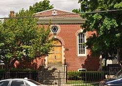
Adams Street Shul
|
Agudas Achim Anshei Sfard Synagogue | |
 The Adams Street Shul | |
| Location | 168 Adams Street, Village of Nonantum, Newton, Massachusetts |
|---|---|
| Area | less than one acre |
| Built | 1912 |
| Website | www.adamsstreet.org |
| NRHP Reference # | 90000035[1] |
| Added to NRHP | March 14, 1990 |
Congregation Agudas Achim Anshei Sfard, more commonly known as The Adams Street Shul, is an Orthodox Jewish synagogue located at 168 Adams Street in the village of Nonantum in Newton, Massachusetts. Built in 1912 for a congregation established in 1911, it is home to Newton's oldest Jewish congregation, and one of the oldest in the region still occupying its original synagogue. Its Romanesque Revival building was listed on the National Register of Historic Places on March 16, 1990.[1]
Architecture and history
The Adams Street Shul is located on the north side of Adams Street a short way east of Watertown Street (Massachusetts Route 16), the main road through Nonantum Village. It is a single-story brick structure, three bays wide, with a pair of round-arch windows flanking the main entrance, which is also set in a round-arch opening. Above the entrance is an oculus window with a Star of David.[2]
The synagogue was built in 1912 by a Jewish congregation established in 1911. It was Newton's only synagogue until 1937, when Temple Emanuel was completed on Ward Street. It was built with significant contribution of labor by the congregation, which included skilled craftsmen. The Torah ark and bihim were added in 1924, the work of a Jewish-Ukrainian craftsman. The interior has seen only modest alterations since its construction.[2] The congregation has remained small but steady, with many families having multiple generations of membership.
See also
References
- 1 2 National Park Service (2007-01-23). "National Register Information System". National Register of Historic Places. National Park Service.
- 1 2 "NRHP nomination for Agudas Achim Anshei Sfard Synagogue". Commonwealth of Massachusetts. Retrieved 2014-04-08.
External links
Coordinates: 42°21′32.50″N 71°12′3.85″W / 42.3590278°N 71.2010694°W
