2006 European blackout
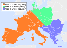
The 2006 European blackout was a major blackout which occurred on Saturday, November 4, 2006. More than 15 million clients of the European Network of Transmission System Operators for Electricity did not have access to electricity during about two hours on this date. The immediate action taken by the Transmission System Operators (TSO) prevented the disturbance from turning into a Europe-wide blackout.
The cause of this major blackout was a planned routine disconnection of the Ems powerline crossing in Northwest Germany to allow a ship to pass beneath the overhead cables. In September, the shipyard had requested the lines, called Conneforde–Diele red and white, to be shut off starting at 01:00 on 5 November. This change was communicated to the neighboring TSOs and they did simulations to ensure stability. As a result, the planned power flow between TSOs was decreased for 00:00 to 06:00 5 November. On 3 November, the shipyard requested the shut-off to be advanced to 2200 on 4 November. E.ON Netz thought that this would be more favorable and approved the request. However, this change was not communicated to the neighboring TSOs until very late so a full analysis was not done. Also, the transfer capacity had already been sold and it was not possible to change it except for force majeure.
Once the second circuit was turned off, this caused alarms due to high power flow. Also the Landesbergen–Wehrendorf line was very close to its limit. Over the next half-hour, the power first went down but then it crept back up. E.ON Netz thought that closing a bus tie would decrease this a bit; in fact, it had the opposite effect and once this was performed the line tripped out.

Twenty eight seconds later, an electrical blackout had cascaded across Europe extending from Poland in the north-east, to the Benelux countries and France in the west, through to Portugal, Spain and Morocco in the south-west, and across to Greece and the Balkans in the south-east.
References
See also
Coordinates: 53°8′55″N 7°22′28″E / 53.14861°N 7.37444°E