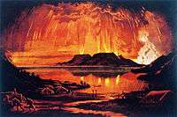
1886 eruption of Mount Tarawera
| Eruption of Mount Tarawera | |
|---|---|
|
Mount Tarawera in Eruption by Charles Blomfield | |
| Volcano | Mount Tarawera |
| Date | June 10, 1886 |
| Time | 2 a.m. |
| Type | Plinian, Peléan |
| Location |
North Island, New Zealand 38°13′0″S 176°31′0″E / 38.21667°S 176.51667°E |
| VEI | 5 |
| Impact | 120-150 people killed, Pink and White Terraces destroyed |
.jpg)
The most recent eruption of Mount Tarawera occurred in the early hours of June 10 1886 in the North Island, New Zealand. It is the deadliest eruption in New Zealand since the arrival of Europeans. Up to 150 people, mostly Māori, were killed, and many settlements were destroyed or buried.[1]
Eruption
Shortly after midnight on Thursday, June 10, 1886, a series of increasingly violent earthquakes struck North Island, New Zealand.[2] Beginning at 2 a.m., the three peaks of Mount Tarawera erupted, spewing molten rock, and columns of smoke and ash up to 10 kilometres (6.2 mi) into the air. The eruption was heard as far as Blenheim. Earthquakes and lightning occurred at the same time.[3]
Effects
The eruption split the mountain and created the Waimangu Volcanic Rift Valley, which lies at the south-western end of the 17 kilometres (11 mi) rift created on June 10, 1886. The famed Pink and White Terraces, natural wonders of New Zealand, were until 2017 thought destroyed. Recent research using a forgotten 1859 survey has revealed the locations of the Pink and White Terraces.[4][5]
The land was covered with millions of tonnes of volcanic ash, mud and debris on average 20 metres (66 ft) thick.[6]
The Māori settlements of Moura, Te Koutu, Kokotaia, Piripai, Pukekiore, Otuapane, Te Tapahoro, Te Wairoa, Totarariki, and Waingongogo were buried or destroyed. The official death toll was reported as 150, and many more were displaced, making the eruption the most deadly in New Zealand history.[7]
Te Wairoa is now a tourist attraction called "The Buried Village". Many people survived by sheltering in Te Wairoa's stronger buildings.[1]
See also
References
- 1 2 "Eruption of Mt Tarawera". Ministry for Culture and Heritage. Retrieved 6 July 2015.
- ↑ "On this day: Tarawera volcanic eruption in 1886". New Zealand Earthquake Commission. Retrieved 6 July 2015.
- ↑ "Mt Tarawera eruption 125th anniversary". Department of Conservation, Government of New Zealand.
- ↑ Bunn, Rex; Nolden, Sascha (2017-06-07). "Forensic cartography with Hochstetter’s 1859 Pink and White Terraces survey: Te Otukapuarangi and Te Tarata". Journal of the Royal Society of New Zealand. 0 (0): 1–18. ISSN 0303-6758. doi:10.1080/03036758.2017.1329748.
- ↑ Bunn and Nolden, Rex and Sascha (December 2016). "Te Tarata and Te Otukapuarangi: Reverse engineering Hochstetter’s Lake Rotomahana Survey to map the Pink and White Terrace locations". Journal of New Zealand Studies. NS23: 37–53.
- ↑ "Waimangu: Geology". GNS Science. Retrieved 6 July 2015.
- ↑ "Okataina Volcanic Centre". New Zealand GeoNet. Retrieved 6 July 2015.
