Zemun Polje
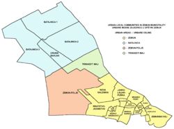
Zemun Polje (Serbian Cyrillic: Земун Поље) is an urban neighborhood of Belgrade, the capital of Serbia. It is located in Belgrade's municipality of Zemun.
Location
Zemun Polje is located on both railway and highway Belgrade-Novi Sad, halfway between the western section of urban Zemun (Nova Galenika) and Batajnica. For decades completely outside the urban section of Belgrade, since the late 1990s it made urban connection with the extended industrial zone of Nova Galenika on the east (through the neighborhood of Kamendin and the fast developing neighborhood of Plavi Horizonti on the south.
Characteristics
Despite even originally being built outside the urban zone of Belgrade (in the 1970s, even the name, Zemun Polje, means Zemun field) it was intended as a neighborhood of Belgrade, not as a separate settlement. The neighborhood of Kamendin was built in the late 1990s, directly adjoining the western section of Zemun Polje.
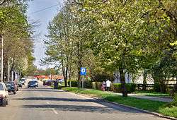
The geometrically shaped neighborhood is mostly residential, with its own railway station in the south. The Corn Institute Zemun Polje has a worldwide reputation in creating corn hybrids.
Sub-neigborhoods of Zemun Polje include Kamendin and Školsko Dobro.
Population
The local community (mesna zajedinca, municipal sub-administrative unit) had a population of 12,901 in 2002[1] and 17,391 in 2011.[2]
Školsko Dobro
Školsko Dobro is the oldest section of Zemun Polje located in its south-west extension. It consists of pavillions with some estimated 500 inhabitants in 2013. The settlement developed in 1953 for the employees of the Corn Institute. It was only in the early 2000’s that some of the communal infrastructure was introduced, like the pavement, street lights and sewage.[3] The name litterally means “School Property” in Serbian.
References
- ↑ Popis stanovništva po mesnim zajednicama, Saopštenje 40/2002, page 4. Zavod za informatiku i statistiku grada Beograda. 26 July 2002.
- ↑ Stanovništvo po opštinama i mesnim zajednicama, Popis 2011. Grad Beograd – Sektor statistike (xls file). 23 April 2015.
- ↑ Daliborka Mučibabić (15 July 2013), "Novi vidici za Plave Horizonte", Politika (in Serbian), p. 17
Coordinates: 44°52′N 20°19′E / 44.867°N 20.317°E
| Wikimedia Commons has media related to Zemun Polje. |