Čabradský Vrbovok
| Čabradský Vrbovok | ||
| Village | ||
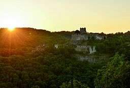
 Čabraď castle at sunset | ||
|
||
| Country | Slovakia | |
|---|---|---|
| Region | Banská Bystrica | |
| District | Krupina | |
| Tourism region | Hont | |
| River | Vrbovok | |
| Elevation | 305 m (1,001 ft) | |
| Coordinates | 48°15′27″N 19°04′29″E / 48.25750°N 19.07472°ECoordinates: 48°15′27″N 19°04′29″E / 48.25750°N 19.07472°E | |
| Area | 23.32 km2 (9 sq mi) | |
| Population | 254 (31. 12. 2015) | |
| Density | 11/km2 (28/sq mi) | |
| First mentioned | 1135 | |
| Mayor | Ján Sliacky[1] | |
| Timezone | CET (UTC+1) | |
| - summer (DST) | CEST (UTC+2) | |
| Postal code | 962 51 | |
| Phone prefix | 421-45 | |
| Car plate | KA | |
  Location of Čabradský Vrbovok in Slovakia | ||
  Location of Čabradský Vrbovok in the Banská Bystrica Region | ||
| Wikimedia Commons: Čabradský Vrbovok | ||
| Website: http://www.dcom.sk/web/cabradsky-vrbovok | ||
Čabradský Vrbovok (Hungarian: Csábrágvarbók) is a village and municipality in the Krupina District of the Banská Bystrica Region of Slovakia.
The village is best known for the ruins of Čabraď Castle.
History
The village was first mentioned in 1135 as Werbouch(later as 1262 Werbouk Inferior, 1285 Warabuk, 1342 Werbok). In 1256 King Bela IV moved colonists from Hontianske Nemce to the location of Čabradský Vrbovok. The village belonged to the Čabraď Castle and the Hunt family. In the 15th century the village became a royal property and in 1513 it belonged to the feudatory Tamas Bakóczy. Also in the 15th century it was besieged by the Bohemian Jiskra. Later on it belonged to the Erdődy and Pálffy families. Between 1547 and 1549 it passed to the noble man Melichar Balassa, in 1584 to the local family Illésházy and in 1622 to the yeoman Koháry. In 1817 it belonged to the Coburg family.
Genealogical resources
The records for genealogical research are available at the state archive "Statny Archiv in Banska Bystrica, Presov, Slovakia"
- Roman Catholic church records (births/marriages/deaths): 1749-1895 (parish A)
- Lutheran church records (births/marriages/deaths): 1728-1896 (parish B)
See also
References
- ↑ Template:Zoznam starostov a primátorov
External links
- http://www.statistics.sk/mosmis/eng/run.html
- http://www.e-obce.sk/obec/cabradskyvrbovok/cabradsky-vrbovok.html
- http://www.regionhont.sk
- http://www.tourist-channel.sk/hrady/indexen.php3
- Surnames of living people in Cabradsky Vrbovok


