Åresjön
| Åresjön | |
|---|---|
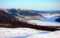
 Åresjön in winter | |
| Location | Jämtland County |
| Coordinates | 63°23′34″N 13°4′34″E / 63.39278°N 13.07611°ECoordinates: 63°23′34″N 13°4′34″E / 63.39278°N 13.07611°E |
| Primary inflows | Indalsälven |
| Primary outflows | Indalsälven |
| Basin countries | Sweden |
| Surface area | 6.4189 km2 (2.4784 sq mi) (1996)[1] |
| Average depth | 9.8 metres (32 ft) (1952)[2] |
| Max. depth | 19.2 metres (63 ft) (1952)[2] |
| Water volume | 61.275 km3 (14.701 cu mi) (1952)[2] |
| Surface elevation | 372.4 metres (1,222 ft) (1996)[1] |
| Frozen | December–May |
| Settlements | Åre |
| References | [1][2] |
Åresjön is a lake situated at 372.4 metres (1,222 ft) above mean sea level[1] in Åredalen, Jämtland County, Sweden, with primary inflow and outflow being Indalsälven. The lake is 6.4189 km2 (2.4784 sq mi) large,[1] it has 9.8 metres (32 ft) of average depth and reaches 19.2 metres (63 ft) at the deepest point.[2] The European route E14 and Mittbanan railway runs along the northern coastline through Åre and some minor settlements. Åre Ski Area lies on the northern bank of the lake; Åreskutan and Renfjället peaks are on each side of the valley. The lake is frozen from late November to early May, which makes it perfect for ice skating.
References
- 1 2 3 4 5 "Sjöareal och sjöhöjd" (PDF) (in Swedish). Swedish Meteorological and Hydrological Institute. 2009-11-25. Retrieved 2010-09-01.
- 1 2 3 4 5 "Sjödjup och sjövolym" (PDF) (in Swedish). Swedish Meteorological and Hydrological Institute. 2009-11-25. Retrieved 2010-09-01.
This article is issued from
Wikipedia.
The text is licensed under Creative Commons - Attribution - Sharealike.
Additional terms may apply for the media files.