Zamboanga del Norte
| Zamboanga del Norte | |||
|---|---|---|---|
| Province | |||
|
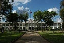
Provincial Capitol in Dipolog City | |||
| |||
 Location in the Philippines | |||
| Coordinates: 08°08′N 123°00′E / 8.133°N 123.000°ECoordinates: 08°08′N 123°00′E / 8.133°N 123.000°E | |||
| Country | Philippines | ||
| Region | Zamboanga Peninsula (Region IX) | ||
| Founded | June 23, 1635 and June 6, 1952 | ||
| Capital | Dipolog City | ||
| Government | |||
| • Type | Province of the Philippines | ||
| • Governor | Roberto Y. Uy (LP) | ||
| • Vice Governor | Senen O. Angeles (LP) | ||
| Area[1] | |||
| • Total | 7,301.00 km2 (2,818.93 sq mi) | ||
| Area rank | 9th out of 81 | ||
| Population (2010)[2] | |||
| • Total | 957,997 | ||
| • Rank | 24th out of 81 | ||
| • Density | 130/km2 (340/sq mi) | ||
| • Density rank | 60th out of 81 | ||
| Divisions | |||
| • Independent cities | 0 | ||
| • Component cities | 2 | ||
| • Municipalities | 25 | ||
| • Barangays | 691 | ||
| • Districts | 3 districts of Zamboanga del Norte | ||
| Time zone | PHT (UTC+8) | ||
| ZIP code | 7100 to 7124 | ||
| Dialing code | 65 | ||
| ISO 3166 code | PH-ZAN | ||
| Spoken languages | Cebuano, Subanen, Zamboangueño Chavacano, Tagalog, English | ||
| Website |
www | ||
Zamboanga del Norte, officially the Province of Zamboanga del Norte, (Filipino: Hilagang Samboanga; Subanen: Utara Sembwangan; Cebuano: Amihanang Zamboanga) is a province of the Philippines located in the Zamboanga Peninsula region in Mindanao. Its capital is Dipolog City and the province borders Zamboanga del Sur and Zamboanga Sibugay to the south and Misamis Occidental to the east. The Sulu Sea lies to the northwest of Zamboanga del Norte. Zamboanga del Norte is the largest province of Zamboanga Peninsula in terms of land area.
History
Prior to its creation as a separate province, Zamboanga del Norte formed the northern portion of the historical province of Zamboanga.
The early history of Zamboanga del Norte is shared with that of Zamboanga City, which had been the center of the entire Mindanao area, most notably during the American era. When Zamboanga City became a chartered city on October 12, 1936, it encompassed the southern tip of the Zamboanga Peninsula and the island of Basilan, making it the largest city in the world in terms of land area.
When Basilan was made into a separate Chartered City, and further, when Republic Act No. 711,[3] issued on June 6, 1952, created two more provinces out of Zamboanga City. One of these provinces was Zamboanga del Norte.
Geography
Zamboanga del Norte comprises the northern portion of the Zamboanga Peninsula. It is bounded on the north and west by the Sulu Sea, on the east by Misamis Occidental, and on the south by Zamboanga del Sur.

The province occupies a total land area of 730,100 hectares (1,804,000 acres).[1] It has an average elevation of 243.8 metres (800 ft), with Mount Dabiak in Katipunan as the highest peak at 2,600 metres (8,500 ft). Other parts, near the coastlines, are plains. The province's irregular coastline runs some 400 kilometres (250 mi) from north to south.
Climate
Zamboanga del Norte has a mild and moderate climate due to evenly distributed rainfall throughout the year. Its southern portion has a longer dry season.
Administrative divisions
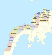
Zamboanga del Norte is subdivided into 25 municipalities and 2 cities. These are further subdivided into 691 barangays, and clustered into 3 congressional districts.[4]
Government
Demographics
| Population census of Zamboanga del Norte | ||
|---|---|---|
| Year | Pop. | ±% p.a. |
| 1990 | 676,862 | — |
| 1995 | 770,697 | +2.46% |
| 2000 | 823,130 | +1.42% |
| 2007 | 907,238 | +1.35% |
| 2010 | 957,997 | +2.00% |
| Source: National Statistics Office[2] | ||
Zamboanga del Norte has a population of 957,997 according to the 2010 census.[2] Its population density is 130/km². It is ranked 24th among the provinces in terms of population and 60th in terms of population density.
The main language spoken is Cebuano. Other languages include Suban-on, Tausug, Zamboangueño, Tagalog, Spanish, and English.
Religion
The predominant religion is Roman Catholicism with 80 percent adherence while Islam is a significant minority. There are also followers of other Christian religions such as Born-again Christians, Jehovah's Witnesses, Baptists, Iglesia Ni Cristo, Church of Christ of Latter Day Saints, Methodists and Seventh-day Adventist.
Economy
About half of the province's land area is devoted to agriculture. Corn, coconut, and rice are the major crops. The province being rich in marine and mineral sources, its fish production has accelerated through the development of fishponds. Commercial fishing has likewise steadily increased through the years, with the yellow fin tuna as the primary species.
In 2006, a study by National Statistics Coordination Board (NSCB), found Zamboanga del Norte Province to be the Philippines' poorest province with a poverty incidence rate of 64.6%, an increase from 47% in year 2000 statistical figures.[6]
Despite of its rich and sea and land resources, it is still the poorest province incident rate of 64.6%. Large foreign mining companies are in the causing adverse effect to the culture and traditions of the indigenous Subanon and other poor settlers.[7]
Media
- Mindanao Examiner
- Mindanao Observer
- Press Freedom
- ABS-CBN Dipolog
- OneTV Dipolog
- Positiv Channel (formerly iTV Prime Dipolog)
References
- 1 2 "List of Provinces". PSGC Interactive. Makati City, Philippines: National Statistical Coordination Board. Retrieved 8 August 2014.
- 1 2 3 "Population and Annual Growth Rates for The Philippines and Its Regions, Provinces, and Highly Urbanized Cities" (PDF). 2010 Census and Housing Population. National Statistics Office. Retrieved 27 October 2012.
- ↑ "Republic Act No. 711 - An Act to Create The Provinces of Zamboanga del Norte and Zamboanga del Sur". Chan Robles Virtual Law Library. Retrieved 28 September 2013.
- 1 2 3 4 5 "Province: Zamboanga del Norte". PSGC Interactive. Makati City, Philippines: Philippine Statistics Authority - National Statistical Coordination Board. Retrieved 13 January 2016.
- ↑ "Total Population by Province, City, Municipality and Barangay: as of May 1, 2010 (Zamboanga Peninsula)" (PDF). 2010 Census of Population and Housing. National Statistics Office. Retrieved 13 January 2016.
- ↑ "Ten poorest provinces in 2003". Press Release. Makati City, Philippines: National Statistical Coordination Board. 6 June 2006. Retrieved 27 October 2012.
- ↑ http://www.youtube.com/watch?v=ysPQSzMXpb8
External links
| Wikimedia Commons has media related to Zamboanga del Norte. |
 Geographic data related to Zamboanga del Norte at OpenStreetMap
- Old website of the Province of Zamboanga del Norte
- Daily Zamboanga Times
 |
Negros Oriental Sulu Sea |
 | ||
| Sulu Sea | |
Misamis Occidental | ||
| ||||
| | ||||
| Zamboanga City | Zamboanga Sibugay / Zamboanga del Sur |
| ||||||||||||||
| |||||||||||||||||||||||||||||||||
| ||||||||||||||||||||||||||||||||||
| |||||||||||||||||||||||||||||||||||||||||||||||||||||||||||||||||||||||||||||


