Yoshikawa, Saitama
| Yoshikawa 吉川市 | ||
|---|---|---|
| City | ||
| ||
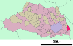 Location of Yoshikawa in Saitama Prefecture | ||
 Yoshikawa Location in Japan | ||
| Coordinates: 35°53′16″N 139°50′40″E / 35.88778°N 139.84444°ECoordinates: 35°53′16″N 139°50′40″E / 35.88778°N 139.84444°E | ||
| Country | Japan | |
| Region | Kantō | |
| Prefecture | Saitama Prefecture | |
| Government | ||
| • Mayor | Taneshige Tobari (since February 1999) | |
| Area | ||
| • Total | 31.62 km2 (12.21 sq mi) | |
| Population (May 1, 2011) | ||
| • Total | 66,773 | |
| • Density | 2,111.73/km2 (5,469.4/sq mi) | |
| Symbols | ||
| • Tree | Osmanthus | |
| • Flower | Azalea, Rhododendron | |
| Time zone | Japan Standard Time (UTC+9) | |
| City Hall Address |
2-1-1 Yoshikawa, Yoshikawa-shi, Saitama-ken 342-8501 | |
| Website |
www | |

Yoshikawa (吉川市 Yoshikawa-shi) is a city in Saitama Prefecture, Japan.
As of 1 May 2011, the city had an estimated population of 66,773, with 25,194 households and a population density of 2,111.73 persons per km². The total area is 31.62 km2 (12.21 sq mi).
The modern city of Yoshikawa was established on April 1, 1996. The area was previously Yoshikawa-machi, but population increase necessitated the change to 'shi' (city)
It is approximately 20 km (12 mi) north-west of Tokyo and bordered on both sides by two small rivers; Edogawa to the west and Nakagawa to the east. Due to this location, Yoshikawa is known for its high-quality river eel production. Its main industries are farming and retail.
Transportation
Yoshikawa is serviced by the JR East Musashino line, and the nearby Misato Junction provides access to the nation's expressways.
International relations
Twin towns and sister cities
Yoshikawa is twinned with:
-
 Lake Oswego, Oregon, United States (1996)
 -
 Ichinoseki Iwate, Japan (1997)
External links
| Wikimedia Commons has media related to Yoshikawa, Saitama. |
- Official website (Japanese)
| |||||||||||||||||||||||||
|