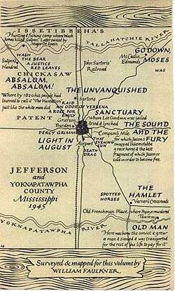
Yoknapatawpha County

Yoknapatawpha County is a fictional county created by the American author William Faulkner, based upon and inspired by Lafayette County, Mississippi, and its county seat of Oxford, Mississippi. Faulkner would often refer to Yoknapatawpha County as "my apocryphal county". From Sartoris onwards, Faulkner would set all but three of his novels in the county (Pylon, The Wild Palms and A Fable were set elsewhere).
Faulkner added a map of Yoknapatawpha County at the end of Absalom, Absalom![1] Contemporary scholars are attempting to map the locations of all Faulkner's fiction.[2]
The word Yoknapatawpha is pronounced [jɒknəpəˈtɔfə] ("Yok'na pa TAW pha"). It is derived from two Chickasaw words—Yocona and petopha, meaning "split land." Faulkner claimed to a University of Virginia audience that the compound means "water flows slow through flat land."[3] Yoknapatawpha was the original name for the actual Yocona River, a tributary of the Tallahatchie which runs through the southern part of Lafayette County,[4] of which Oxford is the seat.
The area was originally Chickasaw land. White settlement started around the year 1800. Prior to the Civil War, the county consisted of several large plantations: Louis Grenier's in the southeast, McCaslin's in the northeast, Sutpen's in the northwest, and Compson's and Sartoris's in the immediate vicinity of Jefferson. Later, the county became mostly small farms. By 1936, the population was 25,611, of which 6,298 were white and 19,313 were black.
References
- ↑ A Faulkner Glossary: Yoknapatawpha County Map.William Faukner on the Web
- ↑ Hagood, Taylor (January 22, 2014). "The Digital Yoknapatawpha Project". Southern Spaces. Retrieved February 18, 2015.
- ↑ Audio of Yoknapatawpha pronunciation and translation from Chickasaw by Faulkner
- ↑ Yocona River. The Geographic Names Information System (GNIS), U.S. Geological Service
| ||||||||||||||||||||||||||||||