Yamatokōriyama
| Yamatokōriyama 大和郡山市 | |
|---|---|
| City | |
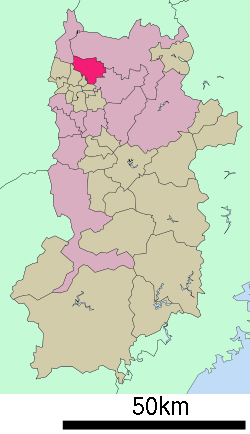
 Location of Yamatokōriyama in Nara Prefecture | |
 Yamatokōriyama Location in Japan | |
| Coordinates: 34°39′N 135°47′E / 34.650°N 135.783°ECoordinates: 34°39′N 135°47′E / 34.650°N 135.783°E | |
| Country | Japan |
| Region | Kansai |
| Prefecture | Nara Prefecture |
| Government | |
| • Mayor | Kiyoshi Ueda |
| Population (April 1, 2015) | |
| • Total | 86,771 |
| Symbols | |
| • Tree | Japanese Black Pine, Peking Willow |
| • Flower | Chrysanthemum, Prunus jamasakura |
| Time zone | Japan Standard Time (UTC+9) |
| City Hall Address |
248-4 Kitakōriyama-chō, Yamatokōriyama-shi, Nara-ken 639-1198 |
| Website |
www |
Yamatokōriyama (大和郡山市 Yamatokōriyama-shi) is a city in Nara Prefecture, Japan.
As of 1 April 2015, the city has an estimated population of 86,771 and 37,343 households.[1]
Geography
Located in the northern portion of the Nara Basin, the Saho River and the Tomio River flow through. The majority of the city is flat, although the portion west of the Tomio River is a little elevated. There are many ponds in the city, which were created for cultivating goldfish.
The settlement of Hieda, located east of the Saho River, is well known for its old fashioned buildings, which are surrounded by moats.
Neighboring municipalities

Town of Yamatokōriyama
Yamatokōriyama adjoins the following municipalities.
Notable locations

Dainagon-zuka
Shrines
- Himeta Shrine
- Yanagisawa Shrine
- Kasuga Shrine
- Koizumi Shrine
Temples
- Matsuo-dera
- Yata-dera
- Jikō-in
- Kyūshō-ji
- Kakuan-ji
Other
- Dainagon-zuka (grave of Toyotomi Hidenaga)
Education
High schools
- Nara Gakuen
- Koriyama High School
Transportation
Rail
Road
- Expressways
- Nishi-Meihan Expressway
- Keinawa Expressway (under construction)
 National Route 24
 National Route 25
 National Route 308
Sister cities
Yamatokōriyama has been twinned with Kofu, Yamanashi in Japan since 1992.[2]
References
- ↑ "市町村別推計人口・世帯数". Nara Prefecture. April 1, 2015. Retrieved May 5, 2015.
- ↑ Sister City Retrieved 7 November 2012.
External links
| Wikimedia Commons has media related to Yamatokoriyama, Nara. |
- Yamatokoriyama City official website (Japanese)
- Yamatokoriyama City official website (English)
| ||||||||||||||||||||||||||||||||||||
|
This article is issued from Wikipedia - version of the Friday, November 06, 2015. The text is available under the Creative Commons Attribution/Share Alike but additional terms may apply for the media files.